An airport is an aerodrome with facilities for flights to take off and land. Airports often have facilities to store and maintain aircraft, and a control tower. An airport consists of a landing area, which comprises an aerially accessible open space including at least one operationally active surface such as a runway for a plane to take off or a helipad, and often includes adjacent utility buildings such as control towers, hangars and terminals.

Ku-ring-gai Chase National Park is a national park on the northern side of Sydney in New South Wales, Australia. The 14,977-hectare (37,010-acre) park is 25 kilometres (16 mi) north of the Sydney central business district and generally comprises the land east of the M1 Pacific Motorway, south of the Hawkesbury River, west of Pittwater and north of Mona Vale Road. It includes Barrenjoey Headland on the eastern side of Pittwater.

Rose Bay is an affluent, harbourside, eastern suburb of Sydney, in the state of New South Wales, Australia. Rose Bay is located seven kilometres east of the Sydney central business district, in the local government areas of Municipality of Woollahra and Waverley Council.

Lord Howe Island is an irregularly crescent-shaped volcanic remnant in the Tasman Sea between Australia and New Zealand, part of the Australian state of New South Wales. It lies 600 km (320 nmi) directly east of mainland Port Macquarie, 780 km (420 nmi) northeast of Sydney, and about 900 km (490 nmi) southwest of Norfolk Island. It is about 10 km (6.2 mi) long and between 0.3 and 2.0 km wide with an area of 14.55 km2, though just 3.98 km2 of that comprise the low-lying developed part of the island. The island is named after Richard Howe, 1st Earl Howe.

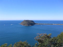
Palm Beach is a suburb in the Northern Beaches region of Greater Sydney, in the state of New South Wales, Australia. Palm Beach is located 41 kilometres (25 mi) north of the Sydney central business district, in the local government area of Northern Beaches Council. Palm Beach sits on a peninsula at the end of Barrenjoey Road near Pittwater and is the northernmost beach in the Greater Sydney Metropolitan area. The population of Palm Beach was 1,593 as at the 2016 census.

The Northern Beaches is a region within Northern Sydney, in the state of New South Wales, Australia, near the Pacific coast. This area extends south to the entrance of Port Jackson, west to Middle Harbour and north to the entrance of Broken Bay. The area was formerly inhabited by the Garigal or Caregal people in a region known as Guringai country.

Whale Beach is a northern beachside suburb of Sydney, in the state of New South Wales, Australia. Whale Beach is located 40 kilometres north of the Sydney central business district, in the local government area of Northern Beaches Council, in the Northern Beaches region.

Pittwater is a semi-mature tide dominated drowned valley estuary, located about 40 kilometres (25 mi) north of the Sydney central business district, New South Wales, Australia; being one of the bodies of water that separate greater Metropolitan Sydney from the Central Coast.

Burning Palms is an unbounded neighbourhood within the locality of Lilyvale and a beach in the Royal National Park, Wollongong, south of Sydney, New South Wales, Australia. It has a surf club and a local cabin community, and is a popular day-walk destination, along with the 'figure-8' rock pools on the rock shelf to the beach's south.

Transport in Sydney is provided by an extensive network of public transport operating modes including metro, train, bus, ferry and light rail, as well as an expansive network of roadways, cycleways and airports. According to the 2006 census, in terms of travel to work or study Sydney has the highest rate of public transport usage among the Australian capital cities of 26.3% with more than 80% of weekday trips to/from Central Sydney being made by public transport. According to the New South Wales State Plan, the state has Australia's largest public transport system. The public transport network is regulated by Transport for NSW.
Moruya Airport is an airport located 3.5 NM northeast of Moruya, New South Wales, Australia, at the mouth of the Moruya River. It is one of two airports with regular passenger flights in the state's South Coast region, but also caters to general aviation and tourism operators, as well as emergency services.

Great Mackerel Beach is a suburb about 43 kilometres north of the Sydney central business district, from 2016 in the local government area of Northern Beaches Council, Sydney, New South Wales, Australia, formerly part of Pittwater Council. It is on the western shores of Pittwater in Ku-ring-gai Chase National Park, beside Currawong Beach, and near Coasters Retreat and Palm Beach. The resident population was 50 at the 2021 census; the median age was 57, with an average of 0.3 children per family and an average of 1.7 people per household. The population was 36 at the 2016 census, 301 at the 2011 census, and 103 in 2006. As of 2021 there were 111 private dwellings, with many people not listed as residents occupying properties during school holidays and weekends. Great Mackerel Beach is frequently referred to as Mackerel Beach or [Great] Mackeral Beach, although the spelling "Mackerel" is becoming standard.
Palm Beach Airport may refer to:
Hyder Seaplane Base is a state owned, public use seaplane base located one nautical mile southeast of the central business district of Hyder, a community in the Prince of Wales-Hyder Census Area of the U.S. state of Alaska. It is included in the National Plan of Integrated Airport Systems for 2011–2015, which categorized it as a general aviation facility. It shares its airspace with the nearby Stewart Aerodrome and Stewart Water Aerodrome and its water runway in the Portland Canal exists on the Canada–United States border.
Port Protection Seaplane Base is a state owned, public use seaplane base located in Port Protection, a community in the Prince of Wales-Hyder Census Area of the U.S. state of Alaska. It is included in the National Plan of Integrated Airport Systems for 2011–2015, which categorized it as a general aviation facility.
Naukati Bay Seaplane Base, formerly known as Nichin Cove Seaplane Base, is a public use seaplane base located at Nichin Cove on the east side of Tuxekan Island, in the Prince of Wales-Hyder Census Area of the U.S. state of Alaska. It is owned by the Naukati Bay Community and located 2 nautical miles (4 km) southwest of Naukati Bay which is on Prince of Wales Island.

Rose Bay Water Airport,, also known as Sydney Water Airport, is a water airport located in the Sydney suburb of Rose Bay, New South Wales, Australia. It is eight kilometres from the city centre and is one of two water airports in Sydney, the other being Palm Beach Water Airport.

Sydney Seaplanes is a domestic and charter carrier in and around Sydney and is the largest seaplane operator in Australia, operating hundreds of flights a week during the peak tourist season. Founded in August 2006 with one aircraft, Sydney Seaplanes has grown in direct response to the growing incoming Asian tourist markets and the leisure VIP market.