
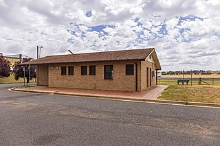
Narromine (/næroʊmaɪn/) is a rural Australian town located approximately 40 kilometres (25 mi) west of Dubbo in the Orana region of New South Wales. The town is at the centre of Narromine Shire. The 2016 census recorded a population of 3,528. Narromine holds strong historical ties to the Australian Military, as it was the location of RAAF No.19 Inland Aircraft Fuel Depot (IAFD) during World War II. The base contributed to the preparation of troops through a training organisation known as the Empire Air Training Scheme (EATS). The town was one of twelve locations for the No.5 Elementary Flying Training School RAAF in 1940.

Nyngan is a town in the centre of New South Wales, Australia, in the Bogan Shire local government area within the Orana Region of central New South Wales. At the 2016 census, Nyngan had a population of 1,988 people. Nyngan is situated on the Bogan River between Narromine and Bourke, on the junction of the Mitchell Highway and Barrier Highway, 656 km (408 mi) south of Charleville and 576 km (358 mi) north-west of Sydney by road. The Barrier Highway starts at Nyngan, and runs west to Cobar and on through Wilcannia and Broken Hill into South Australia.

Bankstown Airport is an airport and business park located in the City of Canterbury-Bankstown, approximately 26 km (16 mi) from the Sydney Central Business District (CBD), Australia and 17 km (11 mi) west of Sydney Airport. It is situated on 313 ha of land and has three parallel runways, several apron areas, a small passenger terminal and a business park, home to more than 160 businesses. The airport, is home to numerous fixed-wing and helicopter flying schools and also caters to charter and private business flights, freight, aeromedical services, recreational flights, aircraft maintenance businesses, private aircraft and emergency services. Bankstown Airport operates 24 hours a day, with limitations placed on night circuit training.

Narrandera Airport is a small regional airport in the local government area of Narrandera in the Riverina region of New South Wales, Australia. The airport is located 4 nautical miles northwest of Narrandera along Irrigation Way. The airport services the towns of Leeton and Narrandera as it is located between the two towns.

Wagga Wagga Airport is located adjacent to RAAF Base Wagga, and 5.8 nautical miles southeast of Wagga Wagga in New South Wales, Australia. The airfield is an operational base, but is leased by the Wagga Wagga City Council on a 30-year lease from the Australian Department of Defence, with RAAF Base Wagga being a ground training base. The airfield is still used by military aircraft, mostly transport aircraft transporting freight or passengers.

Narromine Shire is a local government area in the Orana region of New South Wales, Australia. The Shire is located adjacent to the Mitchell Highway and the Main Western railway line. It was formed on 1 January 1981 from the amalgamation of the Municipality of Narromine and Timbrebongie Shire resulting from the Local Government Areas Amalgamation Act 1980.
Mudgee Airport is an airport located 3 nautical miles north northeast of Mudgee, New South Wales, Australia. The airport is frequently used for technical training.

Trangie is a town in the Orana region of New South Wales, Australia. The town is on the Mitchell Highway 485 kilometres (301 mi) north west of the state capital Sydney. It is part of Narromine Shire local government area. At the 2016 census, Trangie had a population of 1,188. Trangie is on the Main Western railway line, New South Wales
Cootamundra Airport is a small airport in Cootamundra, New South Wales, Australia. The airport is also the venue for the annual GTR Challenge and Drag Battle motorsport event.
Deniliquin Airport is an airport located 2 nautical miles south of Deniliquin, a town in the Riverina region of New South Wales, Australia.

Temora Airport is a small airport located 2 nautical miles northwest of Temora, New South Wales, Australia. Currently no regularly scheduled passenger fights serve the airport. The current owner, the Temora Shire Council, do not charge landing fees for aircraft to use the facility, encouraging a wide variety of general aviation uses, including skydiving, gliding, flight training, kit aircraft assembly and aircraft maintenance. It is also the home of the Temora Aviation Museum, and hosts regularly flying displays and events.
Scone Memorial Airport, is a public airport in the Upper Hunter Valley, 4 km (2.5 mi) northwest of Scone, New South Wales, Australia. It was built to provide a public aerodrome replacing Nandowra aerodrome on located on "Nandowra", approx. 9 km south of Scone.
Cessnock Airport is a civil airport located 6 km (4 mi) North of Cessnock, New South Wales, Australia.
RAAF Station Narromine was a Royal Australian Air Force (RAAF) station located at Narromine, New South Wales, Australia. Narromine Airfield was requisitioned in July 1940 as part of the Empire Air Training Scheme during the Second World War.

Gundaroo Airport is a private airstrip located approximately 2 km (1.2 mi) south of the village of Gundaroo in the Southern Tablelands region of New South Wales, Australia. The airport is on the grounds of "Bowylie Homestead", once the home of American actress Maud Jeffries and now the country estate of high-profile Australian aviator and entrepreneur Dick Smith. The airfield is home to the Bowylie Flying Club, a museum collection of aviation memorabilia and amateur radio equipment. The airside facilities are linked to the private homestead by a miniature railway which intersects the taxiway, requiring aircraft to give way to trains. The airfield may be available to the public by prior arrangement and has been a destination for aero clubs. The airfield has hosted a bi-annual rally for large scale model aircraft. This event attracts participants from clubs across Australia.
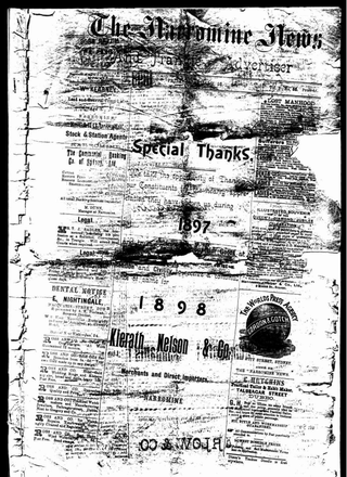
The Narromine News was a newspaper published bi-weekly in Narromine, New South Wales, Australia. It was published as the Narromine News and Trangie Advocate from 1896 to 1979 when its name was changed to the Narromine News.
Timbrebongie Shire was a local government area in the Orana region of New South Wales, Australia.

