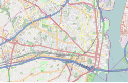
Arlington County, or simply Arlington, is a county in the U.S. state of Virginia. The county is located in Northern Virginia on the southwestern bank of the Potomac River directly across from Washington, D.C., the national capital.

Shirlington is an unincorporated urban area, officially called an "urban village", in the southern part of Arlington County, Virginia, United States, adjacent to the Fairlington area. The word "Shirlington" is a combination of "Shirley" and "Arlington".

Park La Brea is an apartment community in the Miracle Mile District of Los Angeles, California. With 4,255 units located in eighteen 13-story towers and thirty-one two-story buildings, it is among the largest apartment complexes in the continental United States. It sits on 160 acres (0.65 km2) of land.

The Henry G. Shirley Memorial Highway, often shortened to Shirley Highway, consists of a 17.3-mile (27.8 km) portion of Interstates 95 and 395 in the U.S. Commonwealth of Virginia. Shirley Highway was the first limited-access freeway in Virginia. Begun in 1941, the road was completed from U.S. Route 1 in Colchester, Virginia, just north of Woodbridge, to the 14th Street Bridge over the Potomac River between Virginia and Washington, D.C. in 1952.

Parkchester is a planned community and neighborhood originally developed by the Metropolitan Life Insurance Company and located in the central Bronx, New York City. The immediate surrounding area also takes its name from the complex. Its boundaries, starting from the north and moving clockwise, are East Tremont Avenue to the north, Castle Hill Avenue to the east, Westchester Avenue to the south, East 177th Street/Cross Bronx Expressway to the southwest, and White Plains Road to the west. Metropolitan Avenue, Unionport Road, and White Plains Road are the primary thoroughfares through Parkchester.

Fairlington is an unincorporated neighborhood in Arlington County, Virginia, located adjacent to Shirlington in the southernmost part of the county on the boundary with the City of Alexandria. The main thoroughfares are Interstate 395, which divides the neighborhood into North and South Fairlington, State Route 7 and State Route 402.

Parkmerced is a neighborhood in San Francisco, California. It was designed by architects Leonard Schultze and Thomas Dolliver Church in the early 1940s. Parkmerced is the second-largest single-owner neighborhood of apartment blocks west of the Mississippi River after Park La Brea in Los Angeles. It was a planned neighborhood of high-rise apartment towers and low-rise garden apartments in southwestern San Francisco for middle-income tenants.
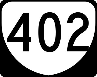
State Route 402 is a primary state highway in the U.S. state of Virginia. Known as Quaker Lane, the state highway runs 1.65 miles (2.66 km) from SR 420 north to Interstate 395 at Shirlington Circle within the independent city of Alexandria.
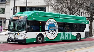
Arlington Transit (ART) is a bus transit system that operates in Arlington County, Virginia, and is managed by the county government. The bus system provides service within Arlington County, and connects to Metrobus, nearby Metrorail stations, Virginia Railway Express, and other local bus systems. Most ART routes serve to connect county neighborhoods to local Metrorail stations, as well as the Shirlington Bus Station. It includes part of the Pike Ride service along Columbia Pike, which is shared with WMATA. In 2023, the system had a ridership of 2,258,200, or about 8,200 per weekday as of the first quarter of 2024.

The Riverton Houses is a large residential development in Harlem, Manhattan, New York City.
Penrose is a neighborhood in Arlington County, Virginia, USA, located roughly three miles from Washington, D.C. It is bordered by Joint Base Myer-Henderson Hall to the east, Columbia Pike to the south, S. Walter Reed Drive and S. Fillmore St. to the west and U.S. Route 50 to the north. The Naval Support Facility Arlington is located within the neighborhood boundaries.

The Village at Shirlington opened as Shirlington Shopping Center in 1944, and was the first large shopping center to open in the Washington, D.C. suburbs and one of the earliest in the United States. It is located along Campbell Avenue at the intersection of Shirley Highway and Quaker Lane / Shirlington Road in Arlington, Virginia. The center has been known since the mid-1980s as The Village at Shirlington.

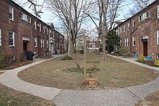
The Arlington Village Historic District is a national historic district located at Arlington County, Virginia. It contains 657 contributing buildings in a residential neighborhood in South Arlington. The area was constructed in 1939, and is a planned garden apartment community that incorporates recreational areas, open spaces, a swimming pool and courtyards within five superblocks. It also includes a shopping center consisting of six stores. The garden apartments are presented as two-story, brick rowhouses with Colonial Revival detailing. There are three building types distinguished by the roof form: flat, gambrel, or gable. Arlington Village was the first large-scale rental project in Arlington County and the first Federal Housing Administration-insured garden apartment development. It was listed on the National Register of Historic Places in 2008.

Colonial Village is a historic garden apartment complex located at Arlington County, Virginia, United States. It contains 226 contributing buildings built in four stages between 1935 and 1940. The buildings hold approximately 1,055 apartments. The brick Colonial Revival-style buildings are situated around courtyards with clusters of five and seven buildings to larger groupings of up to thirteen. Colonial Village was the first Federal Housing Administration-insured, large-scale, rental housing project erected in the United States. The complex has been converted to condominiums split into three phases and two apartment complexes: Colonial Village Apartments and Colonial Village West.
Parkway Village is a garden apartment complex with 675 residential units, located on 35 acres (14 ha) in the Briarwood section of Queens in New York City. It was completed in 1947 to house United Nations employees and delegates, many of whom had faced racial discrimination when they sought housing in other areas.
Alexandria, Virginia is an independent city in the Commonwealth of Virginia, located along the western bank of the Potomac River. The city of approximately 151,000 is about six miles south of downtown Washington, D.C.
Nauck is a neighborhood in the southern part of Arlington County, Virginia, known locally as Green Valley. It is bordered by Four Mile Run and Shirlington to the south, Douglas Park to the west, I-395 to the east, and Columbia Heights and the Army-Navy Country Club to the north. The southeastern corner of the neighborhood borders the City of Alexandria.

The Barcroft–South Fairlington Line, designated as Route 22A, Route 22C, or Route 22F, is a daily bus route operated by the Washington Metropolitan Area Transit Authority between Ballston–MU station of the Orange and Silver lines of the Washington Metro or Skyline City (22F) and Pentagon station of the Yellow and Blue lines of the Washington Metro.
The Hunting Point–Ballston Line, designated as Route 10B, is a daily bus route operated by the Washington Metropolitan Area Transit Authority between Hunting Point and Ballston–MU station of the Orange and Silver lines of the Washington Metro. This line provides service within the neighborhoods in Fairfax County, Alexandria, and Arlington County. Alongside the neighborhoods, it also brings service through the marketplace, businesses, and offices within the counties.