Patriot, Indiana | |
---|---|
Coordinates: 38°50′07″N84°49′48″W / 38.83528°N 84.83000°W | |
Country | United States |
State | Indiana |
County | Switzerland |
Township | Posey |
Area | |
• Total | 0.32 sq mi (0.84 km2) |
• Land | 0.28 sq mi (0.73 km2) |
• Water | 0.04 sq mi (0.10 km2) |
Elevation | 463 ft (141 m) |
Population (2020) | |
• Total | 201 |
• Density | 710.25/sq mi (274.67/km2) |
Time zone | UTC-5 (Eastern (EST)) |
• Summer (DST) | UTC-4 (EDT) |
ZIP code | 47038 |
Area code | 812 |
FIPS code | 18-58392 [3] |
GNIS feature ID | 2396851 [2] |
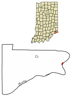
Patriot is a town in Posey Township, Switzerland County, in the U.S. state of Indiana, along the Ohio River. The population was 209 at the 2010 census.
Patriot is the easternmost settlement in Indiana.
According to the 2010 census, Patriot has a total area of 0.26 square miles (0.67 km2), of which 0.22 square miles (0.57 km2) (or 84.62%) is land and 0.04 square miles (0.10 km2) (or 15.38%) is water. [4]
Patriot was originally called Troy, and under the latter name was platted in 1812. [5] The Patriot post office has been in operation since 1827. [6]
Patriot has suffered several calamities in its history. A 1924 fire destroyed a large portion of its downtown. The town was again devastated in the Ohio River flood of 1937. [7]
Census | Pop. | Note | %± |
---|---|---|---|
1880 | 467 | — | |
1890 | 434 | −7.1% | |
1900 | 408 | −6.0% | |
1910 | 340 | −16.7% | |
1920 | 289 | −15.0% | |
1930 | 288 | −0.3% | |
1940 | 257 | −10.8% | |
1950 | 315 | 22.6% | |
1960 | 277 | −12.1% | |
1970 | 216 | −22.0% | |
1980 | 265 | 22.7% | |
1990 | 190 | −28.3% | |
2000 | 202 | 6.3% | |
2010 | 209 | 3.5% | |
2020 | 201 | −3.8% | |
U.S. Decennial Census [8] |
As of the census [9] of 2010, there were 209 people, 76 households, and 59 families residing in the town. The population density was 950.0 inhabitants per square mile (366.8/km2). There were 93 housing units at an average density of 422.7 per square mile (163.2/km2). The racial makeup of the town was 98.1% White, 0.5% Native American, 0.5% Asian, 0.5% from other races, and 0.5% from two or more races. Hispanic or Latino of any race were 1.4% of the population.
There were 76 households, of which 27.6% had children under the age of 18 living with them, 57.9% were married couples living together, 11.8% had a female householder with no husband present, 7.9% had a male householder with no wife present, and 22.4% were non-families. 17.1% of all households were made up of individuals, and 2.6% had someone living alone who was 65 years of age or older. The average household size was 2.75 and the average family size was 2.97.
The median age in the town was 42.1 years. 23% of residents were under the age of 18; 5.1% were between the ages of 18 and 24; 26.3% were from 25 to 44; 34% were from 45 to 64; and 11.5% were 65 years of age or older. The gender makeup of the town was 54.1% male and 45.9% female.
As of the census [3] of 2000, there were 202 people, 73 households, and 60 families residing in the town. The population density was 906.7 inhabitants per square mile (350.1/km2). There were 108 housing units at an average density of 484.8 per square mile (187.2/km2). The racial makeup of the town was 98.02% White, 0.50% African American, 0.50% Native American, and 0.99% from two or more races. Hispanic of any race were 0.99% of the population.
There were 73 households, out of which 38.4% had children under the age of 18 living with them, 63.0% were married couples living together, 13.7% had a female householder with no husband present, and 17.8% were non-families. 13.7% of all households were made up of individuals, and 2.7% had someone living alone who was 65 years of age or older. The average household size was 2.77 and the average family size was 3.00.
In the town, the population was spread out, with 27.2% under the age of 18, 8.9% from 18 to 24, 29.7% from 25 to 44, 26.2% from 45 to 64, and 7.9% who were 65 years of age or older. The median age was 36 years. For every 100 females, there were 114.9 males. For every 100 females age 18 and over, there were 113.0 males.
The median income for a household in the town was $37,500, and the median income for a family was $38,438. Males had a median income of $29,135 versus $26,071 for females. The per capita income for the town was $16,866. About 6.0% of families and 10.4% of the population were below the poverty line, including 17.6% of those under the age of eighteen and none of those 65 or over.
Ulen is a town in Center Township, Boone County, in the U.S. state of Indiana. The population was 117 at the 2010 census. The town is surrounded by the city of Lebanon.
Alton is a town in Boone Township, Crawford County, Indiana, United States. The population was 29 at the 2020 census.
Millhousen is a town in Marion Township, Decatur County, Indiana, United States. The population was 149 at the 2020 census.
St. Paul or Saint Paul is a small town on the border of Decatur and Shelby counties in the U.S. state of Indiana. The population was 1,031 at the 2010 census.
Albany is a town in Delaware and Randolph counties in the U.S. state of Indiana, along the Mississinewa River. The population was 2,295 at the 2020 census. It is part of the Muncie, IN Metropolitan Statistical Area.
Worthington is a town in Jefferson Township, Greene County, Indiana, United States. The population was 1,463 at the 2010 United States Census. It is part of the Bloomington, Indiana, Metropolitan Statistical Area.
Wilkinson is a town in Brown Township, Hancock County, Indiana, United States. The population was 449 at the 2010 census.
Stilesville is a town in Franklin Township, Hendricks County, Indiana, United States. The population was 316 at the 2010 Census.
Straughn is a town in Dudley Township, Henry County, Indiana, United States. The population was 222 at the 2010 census.
Salamonia is a town in Madison Township, Jay County, Indiana, United States. The population was 157 at the 2010 census. The town is situated along the Salamonie River, near its headwaters in Northern Indiana.
Bargersville is a town in White River and Union townships, Johnson County, Indiana, United States. The population was 9,560 at the 2020 census.
New Whiteland is a town in Pleasant Township, Johnson County, Indiana, United States. The population was 5,550 at the 2020 census.
Sidney is a town in Jackson Township, Kosciusko County, in the U.S. state of Indiana. The population was 83 at the 2010 census.
Topeka is a town in Clearspring and Eden townships, LaGrange County, Indiana, United States. The population was 1,153 at the 2010 census. Topeka is located approximately eleven miles south of Shipshewana, Indiana.
Marshall is a town in Washington Township, Parke County, in the U.S. state of Indiana. As of the 2010 census, the population was 324.
Clear Lake is a town located in the northeast corner of Steuben County, Indiana, in Clear Lake Township. As such, is the northeasternmost community in the State of Indiana. The population was 339 at the 2010 census.
Hudson is a town in Salem and Steuben townships, Steuben County, in the U.S. state of Indiana. The population was 518 at the 2010 census.
Boston is a town in Boston Township, Wayne County, Indiana, United States. The population was 138 at the 2010 census.
Mount Auburn is a town in Jackson Township, Wayne County, in the U.S. state of Indiana. The population was 117 at the 2010 census. The town is sandwiched between Dublin and Cambridge City.
Spring Hill is a town in Marion County, Indiana, United States. The population was 95 at the 2020 census. It has existed as an "included town" since 1970, when it was incorporated into Indianapolis as part of Unigov. It is part of Indianapolis, but retains town governmental powers under IC 36-3-1-11.