
Pattadakal (Pattadakallu), also called Raktapura, is a complex of 7th and 8th century CE Hindu and Jain temples in northern Karnataka, India. Located on the west bank of the Malaprabha River in Bagalkot district, this UNESCO World Heritage Site is 23 kilometres (14 mi) from Badami and about 9.7 kilometres (6 mi) from Aihole, both of which are historically significant centres of Chalukya monuments. The monument is a protected site under Indian law and is managed by the Archaeological Survey of India (ASI).
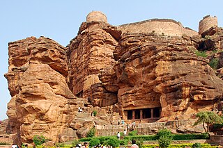
Badami, formerly known as Vātāpi, is a town and headquarters of a taluk by the same name, in the Bagalkot district of Karnataka, India. It was the regal capital of the Badami Chalukyas from 540 to 757. It is famous for its rock cut monuments such as the Badami cave temples, as well as the structural temples such as the Bhutanatha temples, Badami Shivalaya and Jambulingesvara Temple. It is located in a ravine at the foot of a rugged, red sandstone outcrop that surrounds Agastya lake.

Bagalkot district, is an administrative district in the Indian state of Karnataka. The district headquarters is located in the town of Bagalkot. The district is located in northern Karnataka and borders Belgaum, Gadag, Koppal, Raichur and Bijapur. The new Bagalkot district was carved out of Vijayapura in 1997 via Government of Karnataka directive Notification RD 42 LRD 87 Part III. The bifurcated Bagalkot district consists of ten taluks — Badami, Bagalkot, Bilagi, Guledgudda, Rabkavi Banhatti, Hunagund, Ilkal, Jamakhandi and Mudhol, Teradal.

Aihole (ಐಹೊಳೆ), also referred to as Aivalli, Ahivolal or Aryapura, is a historic site of ancient and medieval era Buddhist, Hindu and Jain monuments in Karnataka, India that dates from the sixth century through the twelfth century CE. Most of the surviving monuments at the site date from the 7th to 10th centuries. Located around an eponymous small village surrounded by farmlands and sandstone hills, Aihole is a major archaeological site, featuring over 120 stone and cave temples spread along the Malaprabha river valley, in Bagalakote district.

North Karnataka is a geographical region in Deccan plateau from 300 to 730 metres elevation that constitutes the region of the Karnataka state in India and the region consists of 14 districts. It is drained by the Krishna River and its tributaries the Bhima, Ghataprabha, Malaprabha, and Tungabhadra. North Karnataka lies within the Deccan thorn scrub forests ecoregion, which extends north into eastern Maharashtra.
Ron is a taluka headquarters in Gadag district, Karnataka in India.
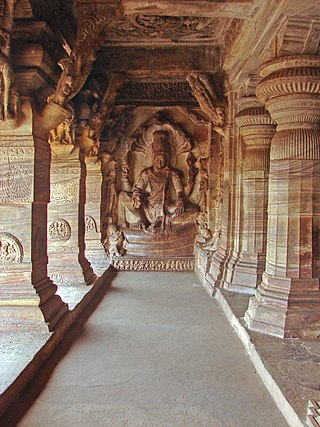
The Badami cave temples are a complex of Buddhist, Hindu and Jain cave temples located in Badami, a town in the Bagalkot district in northern part of Karnataka, India. The caves are important examples of Indian rock-cut architecture, especially Badami Chalukya architecture, and the earliest date from the 6th century. Badami is a modern name and was previously known as "Vataapi", the capital of the early Chalukya dynasty, which ruled much of Karnataka from the 6th to the 8th century. Badami is situated on the west bank of a man-made lake ringed by an earthen wall with stone steps; it is surrounded on the north and south by forts built during Early Chalukya and in later times.

Badami Chalukya architecture is a style in Hindu temple architecture that evolved in the 5th – 8th centuries CE in the Malaprabha river basin, in the present-day Bagalkot district of Karnataka state of India, under the Chalukya dynasty; later it spread more widely. This style is sometimes called the Vesara style and Chalukya style, a term that also includes the much later Western Chalukya architecture of the 11th and 12th centuries. Early Chalukya architecture, used by George Michell and others, equates to Badami Chalukya.

Dravidian architecture, or the Southern Indian temple style, is an architectural idiom in Hindu temple architecture that emerged from Southern India, reaching its final form by the sixteenth century.

Karnataka, the sixth largest state in India, was ranked as the third most popular state in the country for tourism in 2014. It is home to 507 of the 3600 centrally protected monuments in India, second only to Uttar Pradesh. The State Directorate of Archaeology and Museums protects an additional 752 monuments and another 25,000 monuments are yet to receive protection.
Mahakuta Pillar, also known as Makuta pillar, Magada stambha or Mangalesa Dharma Jayastambha, is a deep red sandstone pillar with an early 7th-century inscription of Early Western Chalukya era. It was found near Mahakuta group of Hindu temples near Badami, Karnataka, India. Inscribed with 16 lines of Sanskrit in Old Kannada script by king Mangalesha, it is an important and partly disputed source of historic information about the times of Badami Chalukya, the dynasty, and his influential father Pulakeshin I.

Karnataka, a state in South India has a long association with Jainism, a religion which enjoyed patronage of major historic kingdoms in the state such as the Rastrakuta Dynasty, Western Ganga, Kadamba and Chalukya dynasties and the Hoysala Empire. Today the state is home to a number of Jain monuments, such as temples, Gommata statues and stambhas.

The Mahakuta group of temples is located in Mahakuta, a village in the Bagalkot district of Karnataka state, India. It is an important place of worship for Hindus and the location of a well-known Shaiva monastery. The temples are dated to the 6th or 7th century CE and were constructed by the early kings of the Chalukya dynasty of Badami. The dating of the temples is based on the style of architecture which is similar to that of the temples in nearby Aihole and the information in two notable inscriptions in the complex: the Mahakuta Pillar inscription dated between 595–602 CE ; and an inscription of Vinapoti, a concubine of king Vijayaditya, dated between 696–733 CE and written in the Kannada language and script.

Temples of North Karnataka

Jainism in North Karnataka flourished under the Chalukyas, Kadamba, Rashtrakutas, and Vijayanagara Empire. Imbued with religious feeling, patronage was extended towards the building of Jain temple and it garnered high repute among the people, particularly the ruling classes and the mercantile community; effectively getting treated as the state religion.

The Bhutanatha group of temples are 7th to 12th century Hindu temples to the east of Agastya lake in Badami, Karnataka state, India. It consists of two subgroups – one called the East Bhutanatha group or Bhutanatha main group from 7th to 8th century mostly in the Dravida architecture style; the other called the North Bhutanatha group or Mallikarjuna group from 11th to 12th century mostly in the Nagara architecture. The former illustrates the Badami Chalukya architects, the latter along with the nearby Yellamma temple the Kalyani Chalukya architects.
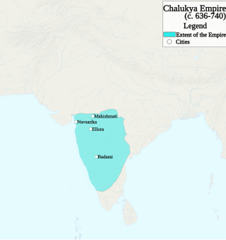
The Chalukya dynasty was a Classical Indian dynasty that ruled large parts of southern and central India between the 6th and the 12th centuries. During this period, they ruled as three related yet individual dynasties. The earliest dynasty, known as the "Badami Chalukyas", ruled from Vatapi from the middle of the 6th century. The Badami Chalukyas began to assert their independence at the decline of the Kadamba kingdom of Banavasi and rapidly rose to prominence during the reign of Pulakeshin II. After the death of Pulakeshin II, the Eastern Chalukyas became an independent kingdom in the eastern Deccan. They ruled from Vengi until about the 11th century. In the western Deccan, the rise of the Rashtrakutas in the middle of the 8th century eclipsed the Chalukyas of Badami before being revived by their descendants, the Western Chalukyas, in the late 10th century. These Western Chalukyas ruled from Kalyani until the end of the 12th century.

The Durga temple is an early 8th-century Hindu temple located in Aihole, Karnataka, India. Originally dedicated to Surya, it has the most embellished and largest relief panels in Aihole depicting artwork of Shaivism, Vaishnavism, Shaktism and Vedic deities. Apart from its fine carvings, it is notable for its apsidal plan – a rare example among early Chalukyan Hindu temple architecture.

Alampuram Navabrahma Temples are a group of nine early Badami Chalukyan Hindu temples dated between the 7th and 9th centuries that are located at Alampuram (Hemalapuram) in Telangana, India, near the meeting point of Tungabhadra River and Krishna River at the border of Andhra Pradesh. They are called Nava-Brahma temples though they are dedicated to Shiva. They exemplify early North Indian Nagara style architecture with cut rock as the building block. The temples of Alampur resemble the style of Pattadakal, Aihole style as they were Karnata Dravida, Vesara style native to Karnataka.

Badami Shivalaya refers to one of three 6th to 8th-century CE Hindu temples in Badami, Bagalkot district of Karnataka, India. They illustrate the early Chalukya style, and are among the better preserved illustrations of Dravida Hindu architecture. They are close to the Badami cave temples and other structural temples near Agasthya lake, but the Badami Shivalyas are located near or on top of different hillocks. These include the Upper Shivalaya, Lower Shivalaya and the better preserved Mallegitti Sivalaya found to the north of the Badami town. These temples include Shiva, Vishnu and Devi-related artwork, as well as depict legends from the Ramayana and Mahabharata.

