
Courtland is an incorporated town in Southampton County, Virginia, United States. It is the county seat of Southampton County.
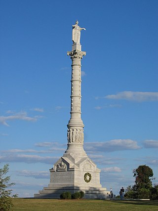
Colonial National Historical Park is a large national historical park located in the Hampton Roads region of Virginia operated by the National Park Service. It protects and interprets several sites relating to the Colony of Virginia and the history of the United States more broadly. These range from the site of the first English settlement at Jamestown, to the battlefields of Yorktown where the British Army was defeated in the American Revolutionary War. Over 3 million people visit the park each year.
Blandford Cemetery is a historic cemetery located in Petersburg, Virginia. Although in recent years it has attained some notoriety for its large collection of more than 30,000 Confederate graves, it contains remains of people of all classes and races as well as veterans of every American war. It holds the largest mass grave of 30,000 Confederates killed in the Siege of Petersburg (1864–65) and other battles during the American Civil War. Although only 3,700 names of the interred are known, it was listed on the National Register of Historic Places in 1992, in part through the efforts of Charlotte Irving, first president of the Historic Blandford Cemetery Foundation. In addition to this cemetery's historic African American section discussed below, it is located adjacent to the People's Memorial Cemetery, a historic African-American cemetery, and small cemeteries containing additional dead from the lengthy Siege of Petersburg and Battle of the Crater in 1864.
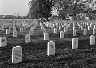
Hampton National Cemetery is a United States National Cemetery in the city of Hampton, Virginia. It encompasses 27.1 acres (11.0 ha), and as of 2014, had over 30,000 interments. There are two separate parts to this facility. The original cemetery is called the "Hampton Section" and is located on Cemetery Road in Hampton, VA. It is on the western side of I-64. The new section which is called the "Phoebus Addition" or the "Phoebus Section" West County Street in Hampton, VA east of I-64. It is less than a mile from the original cemetery. Both sections of the Hampton National Cemetery are closed to new interments.

Winchester National Cemetery is a United States National Cemetery located in the city of Winchester in Frederick County, Virginia. Administered by the United States Department of Veterans Affairs, it encompasses 4.9 acres (2.0 ha), and as of the end of 2005, it had 5,561 interments. It is closed to new interments.

Staunton National Cemetery is a United States National Cemetery located in the Shenandoah Valley, in Staunton, Virginia. Administered by the United States Department of Veterans Affairs, it encompasses just over a single acre, and as of the end of 2005 had 994 interments. It is closed to new interments, and is maintained by the Culpeper National Cemetery.

The Old City Cemetery is a historic cemetery in Lynchburg, Virginia. It is the oldest municipal (city-owned) cemetery still in use today in the state of Virginia, and one of the oldest such burial grounds in the United States. Since the 1990s it has been operated as a history park and arboretum, in addition to being an active cemetery.
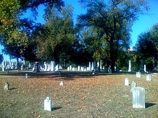
The Shockoe Hill Cemetery is a historic cemetery located on Shockoe Hill in Richmond, Virginia.

Hickory Hill is an estate in Hanover County, Virginia. The 3,300 acre former plantation is located approximately 20 miles (32 km) north of the independent city of Richmond and 5 miles (8.0 km) east of the incorporated town of Ashland. The property was listed in the National Register of Historic Places and the Virginia Landmarks Register in 1974.

Greenlawn Memorial Park, also known as Greenlawn Cemetery, is located at 2700 Parish Avenue, Newport News, Virginia. Greenlawn Memorial Park is a 50-acre (200,000 m2) cemetery located where two natural streams, Mill Dam Creek and Salters Creek, come together. The cemetery has been in continuous operation, serving the Newport News and Hampton, Virginia, since 1888. There are approximately 20,000 burials in the cemetery. Greenlawn Memorial Park is on the National Register of Historic Places.

Zion Evangelical Lutheran Church Cemetery is a historic Evangelical Lutheran cemetery and national historic district located near Speedwell, Wythe County, Virginia. The cemetery includes approximately 250–300 total gravestones. Forty two of the stones have dates ranging from the 1790s to 1840, but all were carved between about 1835 to 1840. It is likely that a skilled carver moved to the area in the mid-1830s and provided stones for many graves, which formerly had been marked with improvised stone or wooden markers, then completed his work by 1840. The thick sandstone markers are Germanic stones with surviving inscriptions.

The Contrabands and Freedmen Cemetery at 1001 S. Washington St. in Alexandria, Virginia was listed on the National Register of Historic Places on August 15, 2012. It was established in February 1864 by the Union military commander of the Alexandria District for use as a cemetery for the burial of African Americans who had escaped slavery, known as contrabands and freedmen. During early Reconstruction, it was operated by the Freedmen's Bureau. It was closed in late 1868, after Congress ended most operations of the Bureau. The last recorded burial was made in January 1869.
National Harmony Memorial Park is a private, secular cemetery located at 7101 Sheriff Road in Landover, Maryland, in the United States. Although racially integrated, most of the individuals interred there are African American. In 1960, the 37,000 graves of Columbian Harmony Cemetery in Washington, D.C., were transferred to National Harmony Memorial Park's Columbian Harmony section. In 1966, about 2,000 graves from Payne's Cemetery in D.C. were transferred to National Harmony Memorial Park as well.

Limestone, also known as Limestone Plantation and Limestone Farm, has two historic homes and a farm complex located near Keswick, Albemarle County, Virginia. The main dwelling at Limestone Farm consists of a long, narrow two-story central section flanked by two wings. the main section was built about 1840, and the wings appear to be two small late-18th-century dwellings that were incorporated into the larger building. It features a two-story porch. The house underwent another major renovation in the 1920s, when Colonial Revival-style detailing was added. The second dwelling is the Robert Sharp House, also known as the Monroe Law Office. It was built in 1794, and is a 2+1⁄2-story, brick and frame structure measuring 18 feet by 24 feet. Also on the property are a contributing shed (garage), corncrib, cemetery, a portion of a historic roadway, and a lime kiln known as "Jefferson's Limestone Kiln" (1760s). Limestone's owner in the late-18th century, Robert Sharp, was a neighbor and acquaintance of Thomas Jefferson. The property was purchased by James Monroe in 1816, after the death of Robert Sharp in 1808, and he put his brother Andrew Monroe in charge of its administration. The property was sold at auction in 1828.

Fairview Cemetery, also known as Citizens' Cemetery and Antioch Cemetery, is a historic cemetery located at Culpeper, Culpeper County, Virginia, United States.

The Cedar Hill Church and Cemeteries are located in historic Rockbridge County, Virginia. The small log church, which also served as a schoolhouse, was built in 1874 evoking the history of Rockbridge County's African American community. The land was given by a white farmer named John Replogle and transferred to” Trustees for the Colored Baptist Congregation” A cemetery was established behind the church, marked today by a scattering of field stone memorials. Because of the rocky ground, a new cemetery was laid out at a separate location around 1890 and is still in use. The Cedar Hill congregation was formed shortly after the Civil War. It consisted of African Americans that basically worked and lived on white-owned farms. The meetings were held in a log dwelling southwest of the present church. Later, the congregation met under a large oak tree that stood approximately one and a half miles west of the present church. Cedar Hill's oak tree meeting-place was similar to the brush arbor churches that many freedman congregations established in Virginia following the Civil war as temporary shelter. It is said that many members were buried near that oak tree that was called as the "Gospel Tree". The tree was destroyed by lightning around 1890, but the stump is still visible and a limb from it is kept at the present church as a historic memento.

West Point Cemetery, also known as Potter's Field and Calvary Cemetery, is a historic cemetery and national historic district located at Norfolk, Virginia. It encompasses three contributing sites, one contributing structure, and one contributing object in an African American graveyard in downtown Norfolk. The cemetery was established in 1873, and includes a grouping of headstones marking the remains of 58 black soldiers and sailors who served in the American Civil War, and a monument honoring these veterans stands over their graves. Other notable elements include the Potter's Field, O’Rourke Mausoleum, and the West Point Cemetery entry sign.
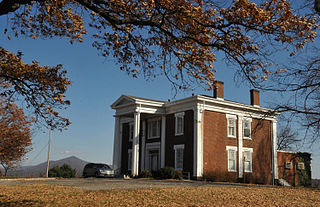
Buena Vista is a historic plantation house located in Roanoke, Virginia. It was built about 1840, and is a two-story, brick Greek Revival style dwelling with a shallow hipped roof and two-story, three-bay wing. The front facade features a massive two-story diastyle Greek Doric order portico. Buena Vista was built for George Plater Tayloe and his wife, Mary (Langhorne) Tayloe. George was the son of John Tayloe III and Anne Ogle Tayloe of the noted plantation Mount Airy in Richmond County and who built The Octagon House in Washington D.C. The property was acquired by the City of Roanoke in 1937, and was used as a city park and recreation center.
The Shockoe Hill African Burying Ground was established by the city of Richmond, Virginia, for the interment of free people of color, and the enslaved. The heart of this now invisible burying ground is located at 1305 N 5th St.

The Shockoe Hill Burying Ground Historic District, located in the city of Richmond, Virginia, is a significant example of a municipal almshouse-public hospital-cemetery complex of the sort that arose in the period of the New Republic following disestablishment of the Anglican Church. The District illustrates changing social and racial relationships in Richmond through the New Republic, Antebellum, Civil War, Reconstruction, and Jim Crow/Lost Cause eras of the nineteenth and twentieth centuries. The Shockoe Hill Burying Ground Historic District occupies 43 acres (17 ha) of land bounded to the south by E. Bates Street, to the north by the northern limit of the Virginia Passenger Rail Authority right-of-way at the southern margin of the Bacon's Quarter Branch valley, to the west by 2nd Street, and to the east by the historic edge of the City property at the former location of Shockoe Creek. The District encompasses most of a 28.5-acre (11.5 ha) tract acquired by the city of Richmond in 1799 to fulfill several municipal functions, along with later additions to this original tract.


