
Westerly is a town on the southwestern coastline of Washington County, Rhode Island, United States, first settled by English colonists in 1661, and incorporated as a municipality in 1669. Westerly is a beachfront community on the south shore of the state with a population of 23,359 as of the 2020 census.
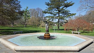
Wilcox Park is a park and arboretum located at 44 High Street, Westerly, Rhode Island. It is open to the public from dawn to 9 pm, without fee, and has been on the National Register of Historic Places since 1973 as Wilcox Park Historic District. The historic district includes 84 houses/buildings of the neighborhood surrounding the park covering a 50-acre (20 ha) area, including the main post office and library within the town of Westerly.
The Bellevue Avenue Historic District is located along and around Bellevue Avenue in Newport, Rhode Island, United States. Its property is almost exclusively residential, including many of the Gilded Age mansions built as summer retreats around the turn of the 20th century by the extremely wealthy, including the Vanderbilt and Astor families. Many of the homes represent pioneering work in the architectural styles of the time by major American architects.
The Newport Historic District is a historic district that covers 250 acres in the center of Newport in the U.S. state of Rhode Island. It was designated a National Historic Landmark (NHL) in 1968 due to its extensive and well-preserved assortment of intact colonial buildings dating from the early and mid-18th century. Six of those buildings are themselves NHLs in their own right, including the city's oldest house and the former meeting place of the colonial and state legislatures. Newer and modern buildings coexist with the historic structures.

The Ocean Drive Historic District is a historic district that covers the long street of the same name along the southern shore of Newport, Rhode Island, United States. It was designated a National Historic Landmark District in 1976, in recognition for its distinctive landscape and architecture, which is less formal and generally not as ostentatious as the grand summer properties of Bellevue Avenue.

The South Central Falls Historic District is a historic district in Central Falls, Rhode Island. It is a predominantly residential area, densely populated, which was developed most heavily in the late 19th century. It is bounded roughly by Broad Street to the east, the Pawtucket city line to the south, Dexter Street to the west, and Rand Street and Jenks Park to the north. It has 377 contributing buildings, most of which were built before 1920. The district was added to the National Register of Historic Places in 1991.
The Blackstone Boulevard Realty Plat Historic District is a historic district roughly bounded by Blackstone Blvd., Rochambeau Ave., Holly St. and Elmgrove Ave. in Providence, Rhode Island.

The Wayland Historic District is a predominantly residential historic district on the east side of Providence, Rhode Island. It is a large area, covering about 122 acres (49 ha), bounded roughly on the north by Everett and Laurel Avenues, on the east by Blackstone Boulevard and Butler Avenue, on the west by Arlington Avenue, and on the south by Angell and South Angell Streets. This area, which was in the 19th century part of the Moses Brown farm, was platted for development in 1891, with most of the construction taking place in the early decades of the 20th century. Most of the residential properties in the district are single-family houses, typically built in revival styles popular at the time. They are set on similarly sized lots with fairly uniform setbacks, and were typically built without garages. There are a number of two-family houses, and a small number of apartment buildings, most of which are found on the arterial roads of the area. There are several religious buildings, including several churches; the most architecturally distinctive religious building is the Jewish Temple Beth El, built 1951–54.
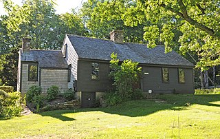
The Lewis–Card–Perry House is a historic house at 12 Margin Street in Westerly, Rhode Island.

The Commodore Oliver Perry Farm is an historic farm on United States Route 1 in South Kingstown, Rhode Island. The farm consists of 250 acres (100 ha) of rolling fields and woodlands on the west side of the road. The main farm complex includes a wood-frame house, barn, a caretaker's residence, and a number of other outbuildings, accessed via a winding private lane. The main house, a two-story gambrel-roofed structure, is of uncertain construction date, and is generally dated to either 1785 or 1815. It has been extensively altered, and been the subject of well-meaning but historically problematic restorations in the first half of the 20th century.
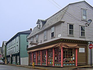
The Westerly Downtown Historic District, commonly called Downtown Westerly, is a historic district encompassing most of the commercial and civic district of Westerly, Rhode Island, United States. It extends from Broad and Union Streets eastward along High Street, and north along Canal Street to Railroad Avenue, where it extends to include the historic railroad station. The district contains a compact and cohesive collection of commercial and civic buildings built primarily during the last three decades of the 19th century and the first three decades of the 20th century, including the Old Town Hall (1872–74), the current Town Hall (1912), the Spanish Colonial railroad station (1912), and the Classical Revival post office (1914).
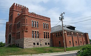
The Westerly Armory is an historic National Guard armory building located on Railroad Avenue, west of downtown Westerly, Rhode Island.

The South Washington Street Historic District is a historic district encompassing 200 years of residential architecture in North Attleborough, Massachusetts. It extends along South Washington Street in the central portion of the town, between Elm Street in the north, and Sutherland Street in the south and includes two properties on Hunking Street. The district was added to the National Register of Historic Places in 1995.

Midtown has an area of six square miles in Columbus, Georgia. It possesses residential neighbourhoods, eleven public schools, the Columbus Museum, the Columbus Public Library, the Muscogee County Public Education Center, the Columbus Aquatic Center and the international headquarters for Aflac. The population of Midtown is 22,000 residents living in 8500 households and is 10 kilometres north of Fort Benning on I-185.

The Harbor Lane–Eden Street Historic District encompasses a neighborhood of Bar Harbor, Maine, consisting of architect-designed summer estates that served as the summer of elite society families of the late 19th and early 20th centuries. Located northwest of the main village and fronting on Frenchman Bay, the district includes nine summer houses that survived a devastating 1947 fire which destroyed many other summer estates. The district was listed on the National Register of Historic Places in 2009.

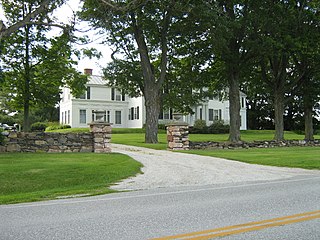
The Parker Homestead is a historic home and grounds in Little Silver, Monmouth County, New Jersey, United States, located at 235 Rumson Road near Sickles Park. The main house was originally built circa 1720, and includes materials from an earlier structure the early and late 19th century, and the 1910s and 1920s. It is one of the oldest extant buildings in the state. The farmstead which also includes three outlying barns were listed on the New Jersey Register of Historic Places and the National Register of Historic Places. in 2011.
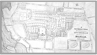
Residence Park is a historic community located in the city of New Rochelle, in Westchester County, New York. It is one of the first planned residential parks, and garden city communities, in the United States. It is located in the southern section of the city, bordered by Neptune Park on the west, Shore Road and Long Island Sound on the south, and Downtown New Rochelle on the north.
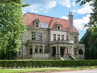
Ram Point is a historic summer estate property at 77 Watch Hill Road in Westerly, Rhode Island. It is located at the head of an eponymous geographic features, which projects into the Pawcatuck River between downtown Westerly and the Watch Hill area. The property includes a suite of buildings, the principal one being a large two story Colonial Revival wood-frame building. The house was built c. 1903 for Dr. John Whitridge Williams to a design most likely by Douglas Thomas, Jr. of Baltimore, Maryland. The property is believed to be one of only two Rhode Island works by Thomas; the other, also designed for a member of the Williams family, is located across Babcock Cove from Ram Point.
Rockledge is a historic summer estate house on Vermont Route 207 in Swanton, Vermont. Architect Charles Saxe in 1918 designed alterations to an early 19th-century farmhouse, that is the principal surviving element of an early 20th-century gentleman's farm. The property was listed on the National Register of Historic Places in 1994.

The Jefferson-Seymour District is a historic district encompassing a residential area on the south side of Hartford, Connecticut. Covering portions of Cedar, Wadsworth, Seymour and Jefferson Streets, it contains a well-preserved collection of late 19th and early 20th-century middle-class residential architecture, primarily executed in brick. It was listed on the National Register of Historic Places in 1979.


