
Calais is a city in Washington County, Maine, United States. As of the 2020 census, it had a population of 3,079, making Calais the largest municipality by population in Washington County, but the third least-populous city in Maine. The city has three Canada–US border crossings over the St. Croix River connecting to St. Stephen, New Brunswick, Canada.

Robbinston is a town in Washington County, Maine, United States. The population was 539 at the 2020 census.

The Granite Railway was one of the first railroads in the United States, built to carry granite from Quincy, Massachusetts, to a dock on the Neponset River in Milton. From there boats carried the heavy stone to Charlestown for construction of the Bunker Hill Monument. The Granite Railway is popularly termed the first commercial railroad in the United States, as it was the first chartered railway to evolve into a common carrier without an intervening closure. The last active quarry closed in 1963; in 1985, the Metropolitan District Commission purchased 22 acres (8.9 ha), including Granite Railway Quarry, as the Quincy Quarries Reservation.
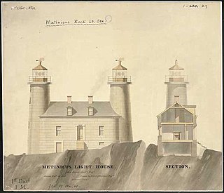
Matinicus Rock Light is a lighthouse on Matinicus Rock, a windswept rock 25 miles (40 km) off the coast of Maine. It is one of eleven seacoast lights off the coast of Maine. First established in 1827, the present surviving structures date to 1857. The lighthouse was added to the National Register of Historic Places as Matinicus Rock Light Station on March 14, 1988.
Rockingham is a historic house that was the home of John Berrien (1711–1772). It served as George Washington's final headquarters of the Revolutionary War. It is located at 84 Laurel Avenue, Franklin Township in Somerset County, New Jersey. It was listed on the National Register of Historic Places in 1970.

Ward Parkway is a boulevard in Kansas City, Missouri, United States. Ward Parkway begins at Brookside Boulevard on the eastern edge of the Country Club Plaza and travels west 2.8 miles along Brush Creek as U.S. Route 56 before turning south near Kansas-Missouri state line. It continues south for 4 miles, terminating at Wornall Road near Bannister Road. A short spur, Brush Creek Parkway, connects Ward Parkway to Shawnee Mission Parkway at State Line Road.

The boundary markers of the original District of Columbia are the 40 milestones that marked the four lines forming the boundaries between the states of Maryland and Virginia and the square of 100 square miles (259 km2) of federal territory that became the District of Columbia in 1801. Working under the supervision of three commissioners that President George Washington had appointed in 1790 in accordance with the federal Residence Act, a surveying team led by Major Andrew Ellicott placed these markers in 1791 and 1792. Among Ellicott's assistants were his brothers Joseph and Benjamin Ellicott, Isaac Roberdeau, George Fenwick, Isaac Briggs and an African American astronomer, Benjamin Banneker.

The 1767 Milestones are historic milestones located along the route of the Upper Boston Post Road between the cities of Boston and Springfield in Massachusetts. The 40 surviving milestones were added to the National Register of Historic Places in 1971. Massachusetts has a total of 129 surviving milestones including those along the upper Post Road. The stones are so named, despite having been placed in many different years, because of a 1767 directive of the Province of Massachusetts Bay that such stones be placed along major roadways. The state highway department was directed in 1960 to undertake their preservation. Many of them underwent a major restoration in 2018.
The town of Barnstable, Massachusetts has four surviving stone markers that were used in colonial days to mark the town's boundaries with its neighbors. All four are listed on the National Register of Historic Places, three of them individually, and one as part of the Old King's Highway Historic District. Barnstable was established in 1639.

This is a list of the National Register of Historic Places listings in Pike County, Pennsylvania.

This is a list of the National Register of Historic Places listings in St. Landry Parish, Louisiana.

This is a list of the National Register of Historic Places listings in Flathead County, Montana.

This is a list of the National Register of Historic Places listings in Pike County, Indiana.

Eastern Cemetery is a historic cemetery at the intersection of Washington Avenue and Congress Street in the Munjoy Hill neighborhood of Portland, Maine. Established in 1668, it is the city's oldest historic site. It has more than 4,000 marked graves with an estimated further 3,000 burials in unmarked plots. It was listed on the National Register of Historic Places in 1973.
Paythorne is a civil parish in Ribble Valley, Lancashire, England. It contains twelve listed buildings that are recorded in the National Heritage List for England. Of these, one is at Grade II*, the middle grade, and the others are at Grade II, the lowest grade. The parish contains the village of Paythorne, and is otherwise rural. Most of the listed buildings are houses, farmhouses, and farm buildings. The other listed buildings include two bridges, a church, a boundary stone, and a shelter for horses.

The Theodore Jellison House, also known locally as the Stone House, is a historic house on River Road in eastern Calais, Maine. Built in 1825, it is one of the oldest surviving residences in the town, and an impressive local example of granite construction. Theodore Jellison, its builder, was a local owner of granite quarries. The house was listed on the National Register of Historic Places in 1984.

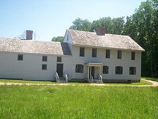
The Mansion House is a historic house on United States Route 1 in Robbinston, Maine. Built about 1785, it is a fine Federal period mansion, historically associated with John Brewer, a leading shipbuilder and militia leader during the War of 1812, and James Shepherd Pike, a journalist who also served during the American Civil War as United States Ambassador to the Netherlands. The house was listed on the National Register of Historic Places in 1973.

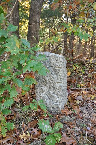
The Indian Stones are a pair of historic markers on Vermont Route 106 in Reading, Vermont. Erected in 1799 in commemoration of a 1754 Native American raid, they are the oldest commemorative markers in the state, and among the oldest in the United States. They were mounted in a single granite slab in 1918, and were listed on the National Register of Historic Places in 1974.


