Pinch District, Memphis

Last updated
View of the Pinch District and Pyramid Arena from the North Wolf-River-Harbor-Memphis.jpg
View of the Pinch District and Pyramid Arena from the North

The Pinch District is a historical district of downtown Memphis roughly bordered by the Wolf River lagoon on the west, Market Street on the south, Danny Thomas Boulevard on the east, and A.W. Willis Avenue on the north.

Contents

History

The area known as the Pinch District was part of the original plan of Memphis, and emerged as the city's first commercial area. It was originally located north of Market Street and south of the Bayou Gayoso, a stream that ran through (now under) downtown Memphis. The name "Pinch" was originally a derisive term, referring to emaciated Irish immigrants who fled the Great Famine in the 1840s. The area was known as Pinch-Gut, in reference to the starving look of many of its impoverished residents. It was home to the earliest immigrant communities in Memphis, mainly Irish, Italian, Russian, Greek, and Jewish. From the 1890s to the 1930s, it was the center of Memphis' Jewish community, with many synagogues and Jewish-owned businesses. After World War II many of the area's residents moved to the eastern suburbs, and businesses began closing. The area became predominantly African-American, and remains so today. During the 1970s, the Pinch was a target of slum clearance and urban renewal. The Barry Homes housing project was constructed in the Pinch in 1970, and the neighborhood was bisected by Interstate 40 as part of the construction of the Hernando de Soto Bridge in 1973. [1]

Growth

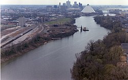
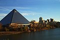
In 1991, the City of Memphis constructed the Pyramid Arena along the Wolf River lagoon. Initial prospects of turning the area into a new entertainment district diminished by the late 1990s. With the arrival of an NBA franchise, the Memphis Grizzlies, the fate of the Pyramid became grim as a new arena was constructed near Beale Street on the southern side of downtown. Both the Grizzlies and the University of Memphis moved their home games to the FedEx Forum in 2004, and the Pyramid closed as an arena. Several proposals for new development were devised in the mid-2000s, though many never materialized. Recent development has centered on MATA's North End Terminal, which operates as the city's main bus terminal. The Pyramid now has been converted into a Bass Pro Shops megastore opened in May 2015, a hint that gentrification may be returning to the struggling neighborhood. [2]

In 2016, conceptual plans for revitalizing the Pinch District were announced. [3] The design calls for a mixed-used district that would complement a $1 billion expansion of St. Jude. New research and office buildings will be located outside the existing St. Jude gates and will have public-facing retail and restaurant tenants at ground level. Additional mixed-use buildings would provide a mix of office, residential, and hotel space. A long-awaited pedestrian bridge to connect the Pyramid to the greater Pinch District is also planned.

See also

Related Research Articles

Memphis Pyramid Arena in Tennessee, United States

The Memphis Pyramid, formerly known as the Great American Pyramid and the Pyramid Arena, is a building located in downtown Memphis, Tennessee, United States, at the banks of the Mississippi River. Built in 1991 as a 20,142-seat arena, the facility was owned and operated jointly by the city of Memphis and Shelby County; Shelby County sold its share to Memphis in April 2009. Its structure plays on the city's namesake in Egypt, known for its ancient pyramids. It is 321 feet (98 m) tall and has base sides of 591 feet (180 m); it is by some measures the tenth-tallest pyramid in the world.

Midtown Memphis, Tennessee is a collection of neighborhoods to the east of Downtown.

Uptown Memphis is a neighborhood located near downtown Memphis, Tennessee. In 1999, the Uptown Partnership renamed the historic North Memphis Greenlaw neighborhood "Uptown" in concert with a public-private revitalization effort that defined Uptown as one hundred city blocks east of the Wolf River and North of A.W. Willis Avenue. The historic Greenlaw section of this neighborhood consists of the thirty city blocks closest to the Wolf River.

Harbor Town, Memphis

Harbor Town is a new urbanist-style neighborhood in Memphis, Tennessee. Harbor Town sits atop 132 acres on a sandbar known as Mud Island. The neighborhood emphasizes the human, not the automobile, and interaction between neighbors is encouraged. It was the collaborative effort of Memphis native and downtown developer Henry Turley, RTKL of Baltimore, Looney, Ricks and Kiss architectural firm from Memphis and consultant, Tony Bologna. They made a simple book that plainly told "do this and don't do that"- development guidelines that would grow Harbor Town into the kind of community now known as New Urbanism. Today, Harbor Town is dense and walkable, offering traditional row houses, contemporary homes, apartments, shops, restaurants, schools, parks, and a marina. It is much studied by city planners from all over the world.

Downtown Memphis, Tennessee

Downtown Memphis, Tennessee is the central business district of Memphis, Tennessee and is located along the Mississippi River between Interstate 40 to the north, Interstate 55 to the south and I-240 to the east, where it abuts Midtown Memphis.

Frayser, Memphis Neighborhood in Memphis, Tennessee, United States

Frayser is a neighborhood on the northside of Memphis, Tennessee, United States. It is named after Memphis physician Dr. J Frayser, who owned a summer home near the railroad. Frayser's boundaries are the Wolf River to the south, the Mississippi River to the west, the Loosahatchie River to the north, and ICRR tracks to the east. The population of Frayser is 45,000.

The Memphis Medical District is an area which was created to provide a central location for medical care, serving both Memphis and the Mid-South.

Swedish Hill Historic District United States historic place

The Swedish Hill Historic District is a former Swedish enclave that is now a residential area of downtown Austin, Texas. Often referred to as "Swede Hill."

Memphis Suspension Railway

The Memphis Suspension Railway or Mud Island Monorail is a suspended monorail that connects the city center of Memphis with the entertainment park on Mud Island. Celebrating its grand opening on July 3, 1982, it is located beneath a footbridge over the Wolf River Lagoon connecting to the southern tip of Mud Island.

Wolfchase is a neighborhood located adjacent to the Bartlett city limits in northeastern Memphis, Tennessee, United States, and is a part of the Memphis metropolitan area. Its name is derived from its proximity to the Wolf River.

Geography of Memphis, Tennessee

The City of Memphis is located on the eastern bank of the Mississippi River in the southwest corner of the U.S. state of Tennessee. It is the regional hub for a tri-state area of Arkansas, Mississippi and Tennessee.

History of Memphis, Tennessee Aspect of history

The history of Memphis, Tennessee and its area began many thousands of years ago with succeeding cultures of indigenous peoples. In the first millennium, it was settled by the Mississippian Culture. The Chickasaw Indian tribe emerged about the 17th century, or migrated into the area. The earliest European exploration may have encountered remnants of the Mississippian culture by Spanish explorer Hernando de Soto. Later French explorers led by René-Robert Cavelier, Sieur de La Salle likely encountered the Chickasaw. The European-American city of Memphis was not founded until 1819. The city was named after the ancient capital of Egypt on the Nile River in North Africa. It rapidly developed as a major trading center for cotton cultivated at the region's large plantations and dependent on the work of enslaved African Americans. In the 19th century, and especially 1878 and 1879, the city suffered severe yellow fever epidemics. In 1878 tens of thousands of residents fled and more than 5,000 died, with hundreds more dying in the next year's epidemic, causing the city to go bankrupt and give up its charter until 1893.

Culture of Memphis, Tennessee

Memphis, Tennessee has a long history of distinctive contributions to the culture of the American South and beyond. Although it is an important part of the culture of Tennessee, the history, arts, and cuisine of Memphis are more closely associated with the culture of the Deep South than the rest of the state. For example, the city's influence on 20th-century music has had worldwide impact. Memphians have had an important role in founding or establishing several important American music genres, including blues, gospel, rock and roll, and "sharecropper" country music.

Sports in Memphis, Tennessee

Sports in Memphis, Tennessee are supported in the city by Memphis Park Services, which offers a wide range of public facilities, including 17 swimming pools, 8 public golf courses, 48 athletic fields hosting a range of 510 youth and 269 adult teams, 130 basketball courts, 7 tennis centers and a soccer complex.

Columbus Square, St. Louis Neighborhood of St. Louis in Missouri, United States

Columbus Square is a neighborhood of St. Louis, Missouri. It is bounded by Cass Avenue to the north, I-70 to the east, Tucker & North 13th Streets to the west, and Cole Street to the south.

Marine Villa, St. Louis Neighborhood of St. Louis in Missouri, United States

Marine Villa is a neighborhood of St. Louis, Missouri. The neighborhood is located just south of the large and historic Anheuser-Busch Brewery complex along the bluffs of the Mississippi River. It is further defined by Cherokee Street's Antique Row on the north, Gasconade Street on the south, South Broadway and Jefferson Avenue on the west, and the Mississippi River on the east.

Baron Hirsch Synagogue United States historic place

The Baron Hirsch Synagogue, established in Memphis, Tennessee circa 1862–1864, is a flagship of American Orthodox Judaism. From modest beginnings, it underwent tremendous growth in the first half of the 20th century, emerging, in the 1950s, as the largest Orthodox congregation in North America, a position it still holds.

Sam Cooper Boulevard Urban freeway/parkway in Memphis, TN, United States

Sam Cooper Boulevard is an urban highway in Memphis, Tennessee, United States. The more recent western segment of the road follows a parkway design, the older eastern portion which was proposed and constructed as a segment of Interstate 40 (I-40) is built as a freeway, without at-grade intersections and traffic lights. The western terminus of Sam Cooper Boulevard is at East Parkway North. At the western termination point of the road there is a short concurrency of East Parkway North with U.S. Route 64, U.S. Route 70, and U.S. Route 79. From its western end, Sam Cooper Boulevard continues east for 5.8 miles (9.3 km) to reach its eastern terminus at the Interstate 40/Interstate 240 interchange.

Flytown was a neighborhood just northwest of downtown Columbus, Ohio, United States. Flytown encompassed portions of the present-day Arena District and western sections of the Victorian Village. In the 19th century, it was considered the center of the Irish-American community in the city after the arrival of immigrants fleeing the Great Famine, and Naghten Street, now Nationwide Boulevard, was nicknamed the "Irish Broadway".

Riverfront Loop Trolley line in Memphis, Tennessee

The Riverfront Loop is a line of the Memphis Area Transit Authority trolley system. It began operation in 1997, as the second line in the system. It runs for 4.1 mi (6.6 km) through downtown Memphis and along the Mississippi riverfront, with 18 stops along the way. It is the longest of the system's three lines, though it concurrent with the Main Street Line for about half of its length. Part of the line offers panoramic views of the Mississippi River from atop to the Chickasaw Bluffs.

References

  1. Laura Nickas. "Pinch District". Tennessee Encyclopedia.
  2. "Bass Pro store slated for 2013". WMC-TV.com. 17 August 2011.
  3. "Pinch District to Move in a New Direction: Up". Daily News. 24 June 2016.

Coordinates: 35°08′12″N90°00′53″W / 35.1366°N 90.0147°W / 35.1366; -90.0147