
Ashley County is a rural South Arkansas county with a culture, economy, and history based on timber and agriculture. Created as Arkansas's 52nd county on November 30, 1848, Ashley County has seven incorporated municipalities, including Hamburg, the county seat and Crossett, the most populous city. The county is also the site of numerous unincorporated communities and ghost towns. The county is named for Chester Ashley, a prominent lawyer in the Arkansas Territory and U.S. senator from the state from 1844 to 1848.
Scott is an unincorporated community and census-designated place (CDP) in Lonoke and Pulaski counties in the central part of the U.S. state of Arkansas. Per the 2020 census, the population was 97. It is part of the Little Rock–North Little Rock–Conway Metropolitan Statistical Area.

Central Arkansas, also known as the Little Rock metro, designated by the United States Office of Management and Budget as the Little Rock-North Little Rock-Conway Metropolitan Statistical Area, is the most populous metro area in the U.S. state of Arkansas. With an estimated 2020 population of 748,031, it is the most populated area in Arkansas. Located at the convergence of Arkansas's other geographic regions, the region's central location make Central Arkansas an important population, economic, education, and political center in Arkansas and the South. Little Rock is the state's capital and largest city, and the city is also home to two Fortune 500 companies, Arkansas Children's Hospital, and University of Arkansas for Medical Sciences (UAMS).

The Eaker site (3MS105) is an archaeological site on Eaker Air Force Base near Blytheville, Arkansas, that was declared a National Historic Landmark in 1996. The site is the largest and most intact Late Mississippian Nodena phase village site within the Central Mississippi Valley, with archaeological evidence indicating a palisaded village some 50 acres (20 ha) in size, with hundreds of structures. The site's major period of occupation was 1350–1450 CE, although evidence of occupation dates back to 600 CE. The site is also hypothesized to have been occupied by the Quapaw prior to a migration further south, after which they made contact with Europeans in the late 17th century.
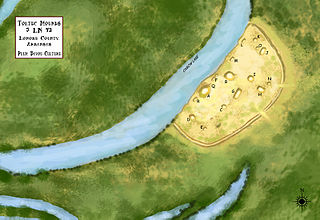
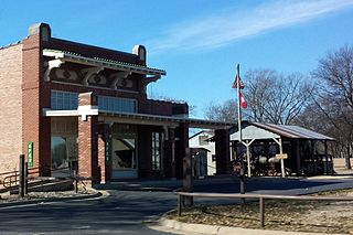
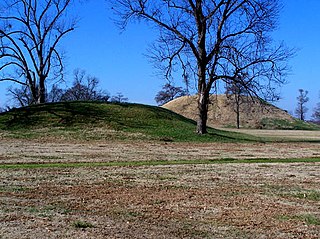
Plum Bayou Mounds Archeological State Park, formerly known as "Toltec Mounds Archeological State Park", also known as Knapp Mounds, Toltec Mounds or Toltec Mounds site, is an archaeological site from the Late Woodland period in Arkansas that protects an 18-mound complex with the tallest surviving prehistoric mounds in Arkansas. The site is on the banks of Mound Lake, an oxbow lake of the Arkansas River. It was occupied by its original inhabitants from the 7th to the 11th century. The site is designated as a National Historic Landmark.

Arkansas Highway 14 is a designation for two state highways in Arkansas. One segment of 208.12 miles (334.94 km) begins east of Table Rock Lake and runs east to Interstate 555 (I-555) at Payneway. A second segment of 19.23 miles (30.95 km) runs from Highway 140 in Lepanto east to Mississippi CR S449 at Golden Lake. Segments of the highway are part of two Arkansas Scenic Byways: Sylamore Scenic Byway in the Ozark National Forest and the Crowley's Ridge Parkway atop Crowley's Ridge.
Wright is an unincorporated community in Jefferson County, Arkansas, United States. Wright is located on Arkansas Highway 256, 7.5 miles (12.1 km) west-northwest of Sherrill. Wright has a post office with ZIP code 72182.
Plum Bayou culture is a Pre-Columbian Native American culture that lived in what is now east-central Arkansas from 650–1050 CE, a time known as the Late Woodland Period. Archaeologists defined the culture based on the Toltec Mounds site and named it for a local waterway.
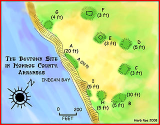
The Baytown Site is a Pre-Columbian Native American archaeological site located on the White River at Indian Bay, in Monroe County, Arkansas. It was first inhabited by peoples of the Baytown culture and later briefly by peoples of the Plum Bayou culture, in a time known as the Late Woodland period. It is considered the type site of the Baytown culture.

The Coy Site is an archaeological site located next to Indian-Bakers Bayou in Lonoke County, Arkansas. It was inhabited by peoples of the Plum Bayou culture, in a time known as the Late Woodland period. The site was occupied between 700 and 1000 CE. It was listed on the National Register of Historic Places in 1995.
The Roland Site is an archaeological site located on Dry Lake, an extinct channel of the White River in Arkansas County, Arkansas. It was inhabited intermittently from the beginning of the common era to late prehistoric times, but its most intensive inhabitation was by peoples of the Plum Bayou culture, in a time known as the Late Woodland period.
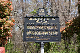
Chalk Bluff was an unincorporated community in Clay County, Arkansas, United States, approximately two miles (3 km) northwest of St. Francis. The town was formed in the 1820s at the point where the St. Francis River cuts through Crowley's Ridge from west to east. The name of the community was derived from the white clay bluff created by this crossing. The founder of the community was Abraham Seitz, who established and operated a ferry crossing and general store in the area from the 1830 until it was destroyed during the Civil War. The community occupied a strategic location and was often referred to in the reports of Union and Confederate forces vying for control of Northeast Arkansas during the war. Several skirmishes occurred near the ferry crossing, one of which was significant it enough to become known as the Battle of Chalk Bluff, which took place in early May 1863. The town was abandoned following the Civil War and most residents moved to the new railroad town, St. Francis, Arkansas. The location was listed on the National Register of Historic Places in 1974.
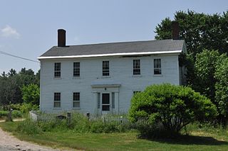
The Plummer Homestead is a historic house museum at 1273 White Mountain Highway in Milton, New Hampshire. Built in the 1810s and repeatedly extended, it dates to the early settlement period of Milton, and is, along with the adjacent Plumer-Jones Farm, one of the oldest farm properties in the state. Both are now part of the New Hampshire Farm Museum. The house was listed on the National Register of Historic Places in 2002.

The Frog Bayou Bridge is a historic bridge in Crawford County, Arkansas, just south of Mountainburg. It is a single-span steel Parker through truss, which formerly carried Arkansas Highway 282 across Frog Bayou, a tributary of the Arkansas River. The bridge is now closed to traffic, and is located at the southern end of Silver Bridge Road. The bridge has a span of 150 feet (46 m) and a total structure length of 209 feet (64 m), and rests on abutments of stone and concrete. The northern approach to the bridge also includes a stone and concrete pier. The bridge was built in 1942.

The Bayou Meto Battlefield, also known as Reed's Bridge Battlefield Heritage Park, is an American Civil War battlefield in Jacksonville, Arkansas. It is the location of the August 27, 1863, Battle of Bayou Meto, in which Confederate forces successfully prevented Union forces from crossing the Bayou Meto River during their advance to capture Little Rock.

The Jim Wright Farmstead Historic District encompasses a well-preserved early 20th-century farmstead in rural White County, Arkansas. The property is located on the south side of Arkansas Highway 258, east of its junction with Arkansas Highway 323, northwest of Bald Knob. It includes a Craftsman style single-story wood-frame farmhouse, with a wraparound porch supported by simple Doric columns, a simple wood-frame garage, and a single-story wood-frame house for tenant workers. It also includes remnants of the farmstead's first house and barn, silo, and a cattle dipping vat. This land was homesteaded in 1860 by the parents of Jim Wright, who is credited with construction of most of the farmstead's surviving features, which were built between 1924 and 1940.
The Palarm Bayou Pioneer Cemetery is a historic cemetery in a rural-suburban area of northern Pulaski County, Arkansas. It is located northwest of Maumelle, between the Arkansas River Trail and Palarm Creek, on a rise that is now part of the gated Mountain Crest residential subdivision. The small cemetery, with just ten marked graves, stands at the top of a rise north of Mt. Pilgrim Baptist Church. Nine of the graves are surrounded by a low stone wall, while one is set outside that enclosure, surrounded by a wrought iron fence. The oldest of the marked graves is that of Daniel Wilson, who died in 1837. The cemetery is probably one of the county's oldest.
Altheimer Unified School District No. 22, previously the Altheimer-Sherrill School District, was a school district headquartered in Altheimer, Arkansas. It served Altheimer, Sherrill, Wabbaseka, and other portions of Jefferson County, including the unincorporated areas of Lake Dick, New Gascony, Pastoria, Plum Bayou, Sweden, Tucker, and Wright. The district in the 1993–2006 period had 333 square miles (860 km2) of territory.
Wabbaseka-Tucker School District, previously the Wabbaseka School District No. 7, was a school district in Jefferson County, Arkansas, serving Wabbaseka, Tucker, and Plum Bayou.
Pastoria, also known as Pastoria Township, in an unincorporated community in Jefferson County, Arkansas. It lost population to Sherrill, Arkansas after a rail line bypassed it in the 19th century.


