
Mount Jackson is a town in Shenandoah County, Virginia, United States. The population was 1,994 at the 2010 census.
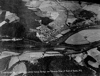
Point of Rocks is an unincorporated community and census-designated place (CDP) in Frederick County, Maryland. As of the 2010 census, it had a population of 1,466.
Fort Myer is the previous name used for a U.S. Army post next to Arlington National Cemetery in Arlington County, Virginia, and across the Potomac River from Washington, D.C. Founded during the American Civil War as Fort Cass and Fort Whipple, the post merged in 2005 with the neighboring Marine Corps installation, Henderson Hall, and is today named Joint Base Myer–Henderson Hall.

Fort Monroe is a former military installation in Hampton, Virginia, at Old Point Comfort, the southern tip of the Virginia Peninsula, United States. It is currently managed by partnership between the Fort Monroe Authority for the Commonwealth of Virginia, the National Park Service, and the city of Hampton as the Fort Monroe National Monument. Along with Fort Wool, Fort Monroe originally guarded the navigation channel between the Chesapeake Bay and Hampton Roads—the natural roadstead at the confluence of the Elizabeth, the Nansemond and the James rivers.

The Second White House of the Confederacy is a historic house located in the Court End neighborhood of Richmond, Virginia. Built in 1818, it served as the main executive residence of the sole President of the Confederate States of America, Jefferson Davis, from August 1861 until April 1865. It currently sits on the campus of Virginia Commonwealth University.

Appomattox Manor is a former plantation house in Hopewell, Virginia, United States. It is best known as the Union headquarters during the Siege of Petersburg in 1864–65.

Fort Pocahontas was an earthen fort on the north bank of the James River at Wilson's Wharf, in Charles City County, Virginia which served as a Union supply depot during the American Civil War. The fort was constructed by African-American soldiers of the United States Colored Troops under the command of Brig. Gen. Edward Augustus Wild.

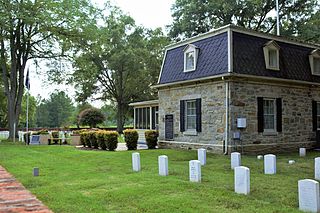
Alexandria National Cemetery is a United States National Cemetery, of approximately 5.5 acres (2.2 ha), located in the city of Alexandria, Virginia. Administered by the United States Department of Veterans Affairs, it is one of the original national cemeteries that were established in 1862. As of 2014, it was site to over 4,500 interments. The cemetery can accommodate the cremated remains of eligible individuals.

City Point National Cemetery is a United States National Cemetery in the community of City Point within the city of Hopewell, Virginia. Administered by the United States Department of Veterans Affairs, it encompasses 6.7 acres (2.7 ha), and as of the end of 2005, had 6,909 interments. It is managed by Hampton National Cemetery.
Fort Harrison National Cemetery is a United States National Cemetery located seven miles (11 km) south of the city of Richmond, in Henrico County, Virginia. Administered by the United States Department of Veterans Affairs, It encompasses 1.5 acres (0.61 ha), and as of the end of 2005, had 1,570 interments.

Winchester National Cemetery is a United States National Cemetery located in the city of Winchester in Frederick County, Virginia. Administered by the United States Department of Veterans Affairs, it encompasses 4.9 acres (2.0 ha), and as of the end of 2005, it had 5,561 interments. It is closed to new interments.

Leesylvania State Park is located in the southeastern part of Prince William County, Virginia. The land was donated in 1978 by businessman Daniel K. Ludwig, and the park was dedicated in 1985 and opened full-time in 1992.

The following outline is provided as an overview of and topical guide to the U.S. state of Virginia:

Bloomsbury Farm was an 18th-century timbered framed house, one of the oldest privately owned residences in Spotsylvania County, Virginia. The house was originally built by the Robinson family sometime between 1785 and 1790. It was architecturally significant for its eighteenth-century construction methods and decorative elements. The surrounding location is also significant as the site of the last engagement between Confederate and Union forces in the Battle of Spotsylvania Courthouse on May 19, 1864. Bloomsbury Farm was added to the National Register of Historic Places in May 2000. The house was demolished in December 2014 by Leonard Atkins, a nearby resident who purchased the property in November 2014 ostensibly to restore it. Atkins cited the building's supposedly poor condition and public safety as the reasons for the abrupt demolition, and he planned to replace the historic house with a new one commensurate in style and value with the modern houses in the surrounding development in which he lives. The farm was removed from the National Register in 2017.

Milford Battlefield is situated in Overall, Virginia in Warren County and Page County, Virginia. It was the site of a battle on September 22–24 during the Valley campaigns of 1864 in the American Civil War. The site is located on property now privately owned.

St. Thomas Chapel, also known as St. Thomas Episcopal Church or St. Thomas Protestant Episcopal Chapel, is a historic building located at 7854 Church Street in Middletown, Frederick County, Virginia, United States. Built in the 1830s, regular services were held at the Episcopal church for almost 100 years. The building has been restored twice, once after being heavily damaged during the Civil War, and again in the 1960s. The church was added to the Virginia Landmarks Register (VLR) and the National Register of Historic Places (NRHP) in 1973.
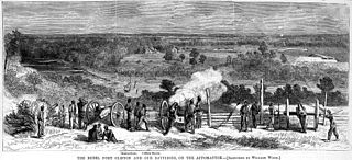
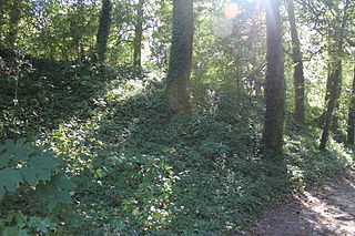
Fort Clifton Archeological Site is a historic American Civil War fort archaeological site located at Fort Clifton Park, Colonial Heights, Virginia. The park is the site of Fort Clifton on the Appomattox River where five Union ships sailed on Confederate troops on June 11, 1864. The Confederate Battery, with cannon emplacements, remained in Confederate hands as the cannons drove the Union attackers away. The park has earthworks that criss-cross the property. Fort Clifton Park has hiking trails and Civil War campaign signage on site.

The Almshouse, also known as the City Home is a historic almshouse and hospital complex located in Richmond, Virginia.
Fort Boykin is a historic site in Isle of Wight County, Virginia, located along the James River. The history of the site is believed to date back to 1623 when colonists were ordered to build a fort to protect them from attacking Native Americans or Spanish marauders. Today the remains of the fort, mostly from the American Civil War, are preserved in a public park.
The Second Battle of Newtonia Site is a battlefield listed on the National Register of Historic Places (NRHP) near Newtonia and Stark City in Missouri. In late 1864, Major General Sterling Price of the Confederate States Army began a raid into Missouri in hopes of diverting Union troops away from more important theaters of the American Civil War. After a defeat at the Battle of Westport on October 23, Price's Army of Missouri began retreating through Kansas, but suffered three consecutive defeats on October 25. By October 28, the retreating Confederates had reached Newtonia, where the Second Battle of Newtonia broke out when Union pursuers caught up with the Confederates. Confederate cavalry under Brigadier General Joseph O. Shelby was initially successful, but after Union reinforcements under Brigadier General John B. Sanborn counterattacked, the Confederates withdrew. The Union troops did not pursue, and Price's men escaped, eventually reaching Texas by December.


