Polk | |
---|---|
Coordinates: 40°56′42″N82°12′53″W / 40.94500°N 82.21472°W | |
Country | United States |
State | Ohio |
County | Ashland |
Area | |
• Total | 1.04 sq mi (2.68 km2) |
• Land | 1.01 sq mi (2.62 km2) |
• Water | 0.02 sq mi (0.06 km2) |
Elevation | 1,266 ft (386 m) |
Population (2020) | |
• Total | 310 |
• Density | 306.32/sq mi (118.25/km2) |
Time zone | UTC-5 (Eastern (EST)) |
• Summer (DST) | UTC-4 (EDT) |
ZIP code | 44866 |
Area code | 419 |
FIPS code | 39-63996 [3] |
GNIS feature ID | 2398993 [2] |
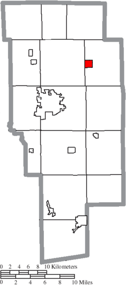
Polk is a village in Ashland County, Ohio, United States. [2] The population was 310 at the 2020 census.
Polk was laid out in 1849. [4] A post office called Polk has been in operation since 1846. [5]
According to the United States Census Bureau, the village has a total area of 1.03 square miles (2.67 km2), of which 1.01 square miles (2.62 km2) is land and 0.02 square miles (0.05 km2) is water. [6]
Census | Pop. | Note | %± |
---|---|---|---|
1880 | 335 | — | |
1890 | 264 | −21.2% | |
1900 | 232 | −12.1% | |
1910 | 250 | 7.8% | |
1920 | 263 | 5.2% | |
1930 | 274 | 4.2% | |
1940 | 275 | 0.4% | |
1950 | 332 | 20.7% | |
1960 | 358 | 7.8% | |
1970 | 435 | 21.5% | |
1980 | 351 | −19.3% | |
1990 | 355 | 1.1% | |
2000 | 357 | 0.6% | |
2010 | 336 | −5.9% | |
2020 | 310 | −7.7% | |
U.S. Decennial Census [7] |
As of the census [8] of 2010, there were 336 people, 129 households, and 87 families living in the village. The population density was 332.7 inhabitants per square mile (128.5/km2). There were 136 housing units at an average density of 134.7 per square mile (52.0/km2). The racial makeup of the village was 97.0% White, 0.3% African American, 0.9% from other races, and 1.8% from two or more races. Hispanic or Latino of any race were 2.4% of the population.
There were 129 households, of which 34.9% had children under the age of 18 living with them, 52.7% were married couples living together, 8.5% had a female householder with no husband present, 6.2% had a male householder with no wife present, and 32.6% were non-families. 27.9% of all households were made up of individuals, and 11.7% had someone living alone who was 65 years of age or older. The average household size was 2.60 and the average family size was 3.10.
The median age in the village was 39.3 years. 27.1% of residents were under the age of 18; 3.8% were between the ages of 18 and 24; 30.1% were from 25 to 44; 27.6% were from 45 to 64; and 11.3% were 65 years of age or older. The gender makeup of the village was 47.6% male and 52.4% female.
As of the census [3] of 2000, there were 357 people, 124 households, and 103 families living in the village. The population density was 354.1 inhabitants per square mile (136.7/km2). There were 127 housing units at an average density of 126.0 per square mile (48.6/km2). The racial makeup of the village was 98.60% White, 0.56% Native American, and 0.84% from two or more races.
There were 124 households, out of which 37.9% had children under the age of 18 living with them, 68.5% were married couples living together, 8.1% had a female householder with no husband present, and 16.9% were non-families. 13.7% of all households were made up of individuals, and 6.5% had someone living alone who was 65 years of age or older. The average household size was 2.88 and the average family size was 3.12.
In the village, the population was spread out, with 26.6% under the age of 18, 10.4% from 18 to 24, 30.3% from 25 to 44, 21.6% from 45 to 64, and 11.2% who were 65 years of age or older. The median age was 34 years. For every 100 females there were 87.9 males. For every 100 females age 18 and over, there were 91.2 males.
The median income for a household in the village was $41,875, and the median income for a family was $43,750. Males had a median income of $30,583 versus $21,250 for females. The per capita income for the village was $16,159. About 4.0% of families and 5.0% of the population were below the poverty line, including 10.5% of those under age 18 and 10.9% of those age 65 or over.
Ashland County is a county located in the northeastern portion of the U.S. state of Ohio. As of the 2020 census, the population was 52,447. Its county seat and largest city is Ashland. The county is named for "Ashland", the home of Senator Henry Clay near Lexington, Kentucky. It was formed in 1846 from parts of Huron, Lorain, Richland and Wayne Counties.
Ashland is a village in Cass County, Illinois, United States. The population was 1,218 at the 2020 census.
Ashland is a village in the northernmost portion of Natchitoches Parish, Louisiana, United States. A few residences and a convenience store to the north spill over into neighboring Bienville Parish. The population was 291 at the 2000 census but declined nine percent to 269 in 2010. The median age was 45.7 years. Ashland is part of the Natchitoches Micropolitan Statistical Area.
Ashland is a town in Aroostook County, Maine, United States. The population was 1,202 at the 2020 census.
McIntosh is a city in Polk County, Minnesota, United States. It is part of the Grand Forks, ND-MN Metropolitan Statistical Area. The population was 606 at the 2020 census.
Flemington is a village in Polk County, Missouri, United States. The population was 148 at the 2010 census. It is part of the Springfield, Missouri Metropolitan Statistical Area.
Polk is a village in Polk County, Nebraska, United States. The population was 322 at the 2010 census.
Ashland is a city in Saunders County, Nebraska, United States. The population was 3,086 at the 2020 census.
Ashland is an unincorporated community and census-designated place (CDP) located within Cherry Hill, in Camden County, in the U.S. state of New Jersey. As of the 2010 United States Census, the CDP's population was 8,302.
Bailey Lakes is a village in Clear Creek Township, Ashland County, Ohio, United States. The population was 349 at the 2020 census.
Hayesville is a village in Vermillion Township, Ashland County, Ohio, United States. The population was 447 at the 2020 census.
Mifflin is a village in Mifflin Township, Ashland County, Ohio, United States. The population was 158 at the 2020 census.
Savannah is a village in Ashland County, Ohio, United States. The population was 329 at the 2020 census.
Athalia is a village in Lawrence County, Ohio, United States, along the Ohio River. The population was 279 at the 2020 census.
Hanging Rock is a village in Lawrence County, Ohio, United States, along the Ohio River. The population was 204 at the 2020 census.
Centuria is a village in Polk County, Wisconsin, United States. The population was 891 at the 2020 census.
Frederic is a village in Polk County, Wisconsin, United States. The population was 1,137 at the 2010 census. It was established as a village in 1901.
Balsam Lake is a village in, and the county seat of Polk County, Wisconsin, United States. The population was 1,009 at the 2010 census. The village is located within the Town of Balsam Lake.
Clayton is a village in Polk County, Wisconsin, United States. The population was 571 at the 2010 census. The village is located within the Town of Clayton.
Milltown is a village in Polk County, Wisconsin, United States. The population was 917 at the 2010 census. The village is located within the Town of Milltown.