The Civilian Conservation Corps (CCC) was a voluntary government work relief program that ran from 1933 to 1942 in the United States for unemployed, unmarried men ages 18–25 and eventually expanded to ages 17–28. The CCC was a major part of President Franklin D. Roosevelt's New Deal that supplied manual labor jobs related to the conservation and development of natural resources in rural lands owned by federal, state, and local governments. The CCC was designed to supply jobs for young men and to relieve families who had difficulty finding jobs during the Great Depression in the United States.
The National Register of Historic Places (NRHP) is the United States federal government's official list of districts, sites, buildings, structures, and objects deemed worthy of preservation for their historical significance or "great artistic value". A property listed in the National Register, or located within a National Register Historic District, may qualify for tax incentives derived from the total value of expenses incurred in preserving the property.

Effigy Mounds National Monument preserves more than 200 prehistoric mounds built by pre-Columbian Mound Builder cultures, mostly in the first millennium CE, during the later part of the Woodland period of pre-Columbian North America. Numerous effigy mounds are shaped like animals, including bears and birds.
The Timbisha are a Native American tribe federally recognized as the Death Valley Timbisha Shoshone Band of California. They are known as the Timbisha Shoshone Tribe and are located in south central California, near the Nevada border. As of the 2010 Census the population of the Village was 124. The older members still speak the ancestral language, also called Timbisha.

Scenic State Park is a Minnesota state park near Bigfork in Itasca County. It encompasses 3,936 acres (1,593 ha) of virgin pine forests that surround Sandwick Lake and Coon Lake. It also includes portions of Lake of the Isles, Tell Lake, Cedar Lake, and Pine Lake. Established in 1921, the Ojibwe tribe had previously used the area for hunting. The park has places for camping, hiking, swimming, fishing, and canoeing.

Kooser State Park is a 250-acre (101 ha) Pennsylvania state park in Jefferson Township, Somerset County, Pennsylvania, in the United States. The park, which borders Forbes State Forest, was built in the 1930s by the Civilian Conservation Corps, who also built the 4-acre (1.6 ha) Kooser Lake by damming Kooser Run. Kooser State Park is on Pennsylvania Route 31 a one-hour drive from Pittsburgh. The park is surrounded by Forbes State Forest.

Fort Omaha, originally known as Sherman Barracks and then Omaha Barracks, is an Indian War-era United States Army supply installation. Located at 5730 North 30th Street, with the entrance at North 30th and Fort Streets in modern-day North Omaha, Nebraska, the facility is primarily occupied by the Metropolitan Community College. A Navy Operational Support Center and Marine Corps Reserve unit, along with an Army Reserve unit occupy the periphery of the 82.5 acres (33.4 ha) fort. The government deeded all but four parcels of the land to the Metropolitan Community College in 1974.
The Historic Preservation Fund (HPF) provides financial support for historic preservation projects throughout the United States. The fund is administered by the National Park Service (NPS), pursuant to the National Historic Preservation Act of 1966 (NHPA). The fund provides state historic preservation agencies with matching funds to implement the act.

The Ponca Tribe of Indians of Oklahoma, also known as the Ponca Nation, is one of two federally recognized tribes of Ponca people. The other is the Ponca Tribe of Nebraska. Traditionally, peoples of both tribes have spoken the Omaha-Ponca language, part of the Siouan language family. They share many common cultural norms and characteristics with the Omaha, Osage, Kaw, and Quapaw peoples.

Backbone State Park is Iowa's oldest state park, dedicated in 1919. Located in the valley of the Maquoketa River, it is approximately three miles (5 km) south of Strawberry Point in Delaware County. It is named for a narrow and steep ridge of bedrock carved by a loop of the Maquoketa River originally known as the Devil's Backbone. The initial 1,200 acres (490 ha) were donated by E.M. Carr of Lamont, Iowa. Backbone Lake Dam, a relatively low dam built by the Civilian Conservation Corps (CCC) in the 1930s, created Backbone Lake. The CCC constructed a majority of trails and buildings which make up the park.

Westmoreland State Park lies within Westmoreland County, Virginia. The park extends about one and a half miles along the Potomac River and covers 1,321 acres. The Horsehead Cliffs provide visitors with a panoramic view of the Potomac River, and lower levels feature fossils and beach access. The park offers hiking, camping, cabins, fishing, boating and swimming, although mechanical issues have kept the swimming pool closed since 2021. Located on the Northern Neck Peninsula, the park is close to historical sites featuring earlier eras: George Washington's birthplace and Stratford Hall, the birthplace of Robert E. Lee.

Creek National Capitol, also known as Creek Council House, is a building in downtown Okmulgee, Oklahoma, in the United States. It was capitol of the Muscogee (Creek) Nation from 1878 until 1907. They had established their capital at Okmulgee in 1867, after the American Civil War.
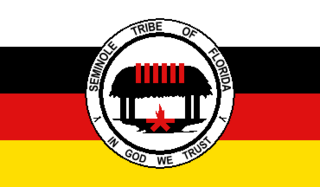
The Seminole Tribe of Florida is a federally recognized Seminole tribe based in the U.S. state of Florida. Together with the Seminole Nation of Oklahoma and the Miccosukee Tribe of Indians of Florida, it is one of three federally recognized Seminole entities. It received that status in 1957. Today, it has six Indian reservations in Florida.

Native American tribes in the U.S. state of Nebraska have been Plains Indians, descendants of succeeding cultures of indigenous peoples who have occupied the area for thousands of years. More than 15 historic tribes have been identified as having lived in, hunted in, or otherwise occupied territory within the current state boundaries.

CCC Camp NP-4, also known as the Horse Concessioner Dormitory and the Climbing Concession Office, at Jenny Lake in Grand Teton National Park was the largest Civilian Conservation Corps camp in Grand Teton. Located at the South end of Jenny Lake, the camp housed young men from 1934 to 1942, who worked on improvements to trails, campsites, employee housing, utilities and timber salvage at Jackson Lake. The surviving structures include a messhall and a bathhouse.
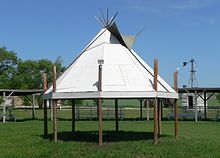
The Ponca Reservation of the Ponca Tribe of Nebraska is located in northeast Nebraska, with the seat of tribal government located in Niobrara, Knox County. The Indian reservation is also the location of the historic Ponca Fort called Nanza. The Ponca tribe does not actually have a reservation because the state of Nebraska will not allow them to have one. However, they do in fact have a 15-county service delivery area, including counties spread throughout Nebraska, South Dakota and Iowa.

This is a list of the National Register of Historic Places listings in Knox County, Nebraska.

The Pawnee Agency and Boarding School District lies east of the city of Pawnee in Pawnee County, Oklahoma. Other names are: Pawnee Indian Agency, Pawnee Indian School and Pawnee Indian Boarding School. The District occupies approximately 29 acres (12 ha) of the Pawnee Tribal Reserve, a 726 acres (294 ha) tract that is owned by the Pawnee tribe. Black Bear Creek divides the District from the town. The Pawnee Agency was established as a post office on May 4, 1876.

The Ponca Historic District is a historic district in Ponca, Nebraska that was listed on the National Register of Historic Places in 1979. It includes the commercial center of Ponca, including 38 contributing buildings.

Judi M. gaiashkibos is a Ponca-Santee administrator, who has been the executive director of the Nebraska Commission on Indian Affairs since 1995. According to journalist John Mabry, her surname "is pronounced 'gosh-key-bosh' and spelled without a capital in recognition "that the two-legged are not superior to the four". She is an enrolled member of the Ponca Tribe of Nebraska.