
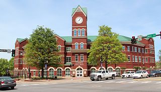
Canton is a city in and the county seat of Cherokee County, Georgia, United States. As of the 2010 census, the city had a population of 22,958, up from 7,709 in 2000.
Cumming is a city in Forsyth County, Georgia, United States, and the sole incorporated area in the county. It is a suburban city, and part of the Atlanta metropolitan area. In the 2020 census, the population is 7,318, up from 5,430 in 2010. Surrounding unincorporated areas with a Cumming mailing address have a population of approximately 100,000. Cumming is the county seat of Forsyth County.

The Chattahoochee River forms the southern half of the Alabama and Georgia border, as well as a portion of the Florida and Georgia border. It is a tributary of the Apalachicola River, a relatively short river formed by the confluence of the Chattahoochee and Flint rivers and emptying from Florida into Apalachicola Bay in the Gulf of Mexico. The Chattahoochee River is about 430 miles (690 km) long. The Chattahoochee, Flint, and Apalachicola rivers together make up the Apalachicola–Chattahoochee–Flint River Basin. The Chattahoochee makes up the largest part of the ACF's drainage basin.

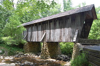
Watson Mill Bridge State Park is a 1,018-acre (4.12 km2) Georgia state park located near Comer and Carlton on the South Fork of the Broad River. The park is named for the Watson Mill Bridge the longest original-site covered bridge in Georgia, which spans 229 feet (70 m) across the South Fork of the Broad River. The site is listed on the National Register of Historic Places as the Watson Mill Covered Bridge and Mill Historic District. The bridge, built in 1885, is supported by a Town lattice truss system held together with wooden pegs also known as trunnels. Georgia once had over 200 covered bridges, but only 20 now remain. The park also offers a scenic nature trail and a new hiking/riding trail that winds through the thick forests and along the rivers edge.
Port Royal State Historic Park is a 26 acre historic area on the border of Montgomery and Robertson. The community of Port Royal is the namesake of the site. Port Royal existed as a town from 1797 to 1940, when the post office officially closed. The Red River runs through the center of the park. The park was established to preserve the former town and the elements of early Tennessee history, the history of the Red River Valley, as well as the heritage of the Trail of Tears and the Black Patch Tobacco Wars.
There were several historic mills around the metro Atlanta area, for which many of its current-day roads are still named. Most of the mills date back to the 1820s and 1830s, and were built along the area's many streams. The locations of many of these mills are shown on a map of 1875 showing U. S. military operations around Atlanta in 1864. This map is now located in the U. S. Library of Congress but can be seen on the webpage linked here.
Historic ferries operated on rivers around Atlanta, Georgia area, and became namesakes for numerous current-day roads in north Georgia. Most of the ferries date to the early years of European-American settlement in the 1820s and 1830s, when parts of the region were still occupied by cherokee and other Native American communities.

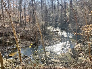
Sope Creek is an 11.6-mile-long (18.7 km) stream located in Cobb County, Georgia, United States. It is a significant tributary of the Chattahoochee River. It was known as Soap Creek during the 19th century. A section of Sope Creek runs through the Chattahoochee River National Recreation Area.

New Echota was the capital of the Cherokee Nation in the Southeastern United States from 1825 until their forced removal in the late 1830s. New Echota is located in present-day Gordon County, in northwest Georgia, north of Calhoun. It is south of Resaca, next to present day New Town, known to the Cherokee as Ꭴꮝꮤꮎꮅ, Ustanali. The site has been preserved as a state park and a historic site. It was designated in 1973 as a National Historic Landmark District.
Pisgah Covered Bridge is a wooden covered bridge that spans the west fork of the Little River in Randolph County, North Carolina. It is one of two remaining original historic covered bridges in the state, and is designated as both a local and federal historic landmark.

The Augusta Canal is a historic canal located in Augusta, Georgia, United States. The canal is fed by the Savannah River and passes through three levels in suburban and urban Augusta before the water returns to the river at various locations. It was devised to harness the water power at the fall line of the Savannah River to drive mills, to provide transportation of goods, and to provide a municipal water supply. It is the only canal in the US in continuous use for its original purposes of providing power, transport, and municipal water.
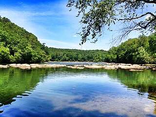
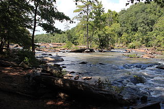
Chattahoochee River National Recreation Area (CRNRA) preserves a series of sites between Atlanta and Lake Sidney Lanier along the Chattahoochee River in Georgia, U.S. The 48-mile (77 km) stretch of the river affords public recreation opportunities and access to historic sites. The national recreation area, a National Park Service unit, was established on August 15, 1978, by President Jimmy Carter.

Johns Creek is a city in Fulton County, Georgia, United States. According to the 2020 census, the population was 82,453. The city is a northeastern suburb of Atlanta.
Sweetwater Creek State Park is a 2,549 acres (10.32 km2) Georgia state park in east Douglas County, 15 miles (24 km) from downtown Atlanta. The park is named after Sweetwater Creek which runs through it. Cherokee people were forcibly removed from the area and it eventually became home to the New Manchester Manufacturing Company and mill town of New Manchester. During the American Civil War the textile mill and general store were burned down by the Union Army and the women and children taken away and eventually sent to Louisville, Kentucky and Indiana as refugees.
There were several historic bridges around the metro Atlanta, Georgia area, for which many of its current-day roads are named. Many of them originated as ferries, dating back to the 1820s and 1830s, and carrying travelers across the Chattahoochee River and several other smaller rivers. Several were also covered bridges, very few of which remain as historic sites.
The Autrey Mill Nature Preserve & Heritage Center is located in Johns Creek, Georgia, United States.
The Arabia Mountain Path (AMP) is a paved biking and hiking trail connecting sites within the Arabia Mountain National Heritage Area, Georgia, United States, built by the PATH Foundation. The trail covers more than 30 linear miles and features hills, sections of boardwalk, a serpentine bridge, and access to 13 free trail head parking areas. The AMP connects a number of visitor destinations and recreational areas including Panola Mountain State Park, the Monastery of the Holy Spirit, Davidson-Arabia Mountain Nature Preserve, the Mall at Stonecrest, and historic Lithonia, Georgia.

The Cromer's Mill Covered Bridge, spanning Nails Creek near Carnesville, Georgia, was built in 1907. It was listed on the National Register of Historic Places in 1976.
Nickajack Creek is a stream in Cobb and Fulton counties in the U.S. state of Georgia. It is a tributary to the Chattahoochee River. Groundwater serves as the water source, with the creek beginning in Marietta, Georgia. The creek runs through the city of Smyrna and terminates at the Chattahoochee River in the town of Mableton.


