Berkley was an incorporated town in Norfolk County, Virginia. Chartered by an Act of Assembly in 1890, the Town of Berkley was located directly across the Eastern Branch Elizabeth River from the City of Norfolk in the South Hampton Roads area.

Colonial Place is a residential neighborhood in Norfolk, Virginia. It is a peninsula bordered by 38th Street on the south, and surrounded on three sides by the Lafayette River. It is a relatively racially mixed area that includes mostly single family homes and a few apartment buildings. Many large homes front the water and Mayflower Road arches around the shore of the river.

Park Place is a neighborhood in the western half of Norfolk, Virginia. Its boundaries are roughly Granby Street on the east, Colley Avenue on the west, 23rd Street on the south and up to 38th Street to the north. Within these boundaries Park Place is made up of 4 historic subdivisions; Virginia Place, East Kensington, Park Place, and East Old Dominion Place.

The Lower Basin Historic District is a national historic district located in Lynchburg, Virginia. The district defines a commercial and industrial warehouse area located between the downtown commercial area to the south and the James River waterfront to the north. The district contains a variety of mostly late 19th- and early 20th-century, multi-story, brick warehouses and factories, two-to-three-story brick commercial buildings, and a number of structures associated with the James River and Kanawha Canal and the Norfolk and Western and Chesapeake and Ohio Railways. The district is named for a wide basin of the canal that once extended between Ninth Street and Horseford Road, and contains 60 contributing buildings, two contributing structures, and one contributing object-a monument commemorating the site of 18th-century Lynch's Ferry.

The Port Republic Road Historic District is a national historic district in Waynesboro, Virginia. In 2002, it included 83 buildings deemed to contribute to the historic character of the area, plus one other contributing structure and one contributing site, a foundation. They include buildings such as houses, garages, sheds, commercial buildings, churches, and meeting halls, and structures such as carports and animal sheds. The historically African-American neighborhood developed after the American Civil War. Notable buildings include the Shiloh Baptist Church (1924), the early-20th century Elks and Abraham lodges, the Rosenwald School, which incorporates a 1938-39 auditorium/gymnasium, and Tarry's Hotel (1940).

Shenandoah Historic District is a national historic district located at Shenandoah, Page County, Virginia. The district includes 451 contributing buildings, 3 contributing sites, and 4 contributing structures in the town of Shenandoah. They include residential, commercial, and institutional buildings in a variety of popular late-19th century and early-20th century architectural styles. Notable buildings include the Eagle Hotel and annex, Norfolk and Western Railway YMCA, Shenandoah General Store, Fields United Methodist Church, Christ United Methodist Church, St. Peter's Lutheran Church, Norfolk and Western Railway Station, and Shenandoah High School. Located in the district is the separately listed Shenandoah Land and Improvement Company Office.

Centreville–Fentress Historic District is a national historic district located at Chesapeake, Virginia. The district encompasses 24 contributing buildings and 10 contributing structures in a rural farming community that developed a small commercial core. It was developed starting in the 1880s, with the addition of the Norfolk and Elizabeth City Railroad link to the Albemarle and Chesapeake Canal. Notable resources include the Fentress House, Colonial Revival style Centerville Baptist Church (1925), New Burfoot House (1925), Queen Anne style George Jackson House (1890), the Norfolk and Elizabeth City, NC Railroad Tracks, and a 1920 commercial building.
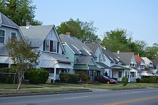
South Norfolk Historic District is a national historic district located at Chesapeake, Virginia. The district encompasses 668 contributing buildings and 1 contributing site in what started as a planned community of Norfolk County, Virginia and grew to become an independent city. South Norfolk was never part of Norfolk, Virginia. In fact, the two cities are separated by the Eastern Branch of the Elizabeth River. South Norfolk is a primarily residential district that was developed between 1890 and 1930. The dwellings include representative examples of the Colonial Revival, Stick Style, and Queen Anne styles. The district also includes several churches, a school, a park, and a small local business district.

Sunray Agricultural Historic District is a national historic district located at Chesapeake, Virginia. The district encompasses 188 contributing buildings, 90 contributing sites, 2 contributing structures, and 1 contributing object in the early 20th-century immigrant farming community of Sunray. It includes early 20th century vernacular farmhouses, agricultural buildings, Sunray School (1922), and St. Mary's Catholic Church (1915-1916). The district also includes a tidal ditch system, the abandoned Virginian Railway Tracks (1909), and agricultural fields laid out with the platting of 1908.

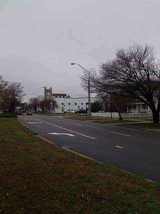
The Riverview Historic District is a national historic district located at Norfolk, Virginia. It encompasses 200 contributing buildings in a primarily residential section of Norfolk. It developed primarily during the first quarter of the 20th century, as a suburban community north of the growing downtown area of Norfolk. The neighborhood includes notable examples of a variety of Late Victorian and Late 19th And 20th Century Revival styles.

The West Freemason Street Area Historic District is a national historic district located at Norfolk, Virginia. It encompasses 48 contributing buildings in a primarily residential section on the western edge of the center city of Norfolk. It developed between the late-18th and early-20th centuries and includes notable examples of the Federal, Greek Revival, and Late Victorian styles. Notable buildings include Kenmure House Glisson House, Whittle House, McCullough Row, and the Camp-Hubard house. Located in the district is the separately listed Allmand-Archer House.

Fort Norfolk is a historic fort and national historic district located at Norfolk, Virginia. With the original buildings having been built between 1795 and 1809, the fort encloses 11 buildings: main gate, guardhouse, officers' quarters, powder magazine, and carpenter's shop. Fort Norfolk is the last remaining fortification of President George Washington's 18th century harbor defenses, later termed the first system of US fortifications. It has served as the district office for the U.S. Army Engineer District, Norfolk since 1923.
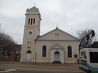
Trinity Episcopal Church is a historic Episcopal church located in Portsmouth, Virginia. It was built between 1828 and 1830, and is a stuccoed brick building. It has an attached bell tower. Also on the property is the contributing parish house, built in 1887. During the American Civil War, the church was used as a hospital.

Portsmouth Courthouse, also known as Norfolk County Courthouse, is a historic courthouse building located at Portsmouth, Virginia, United States. It was built in 1846, and is a one-story with basement, Greek Revival style brick building. It measures 78 feet wide by 57 feet deep. The building is topped by a paneled parapet with Doric order entablature supported by plain Greek Doric pilasters. The building remained in use as a courthouse until 1960, when the county government moved to Great Bridge.
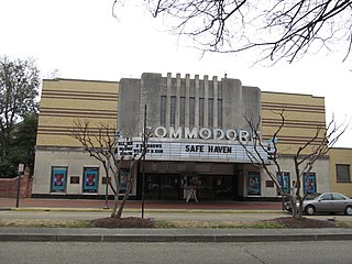
Commodore Theatre is an historic movie theater located at Portsmouth, Virginia. It was built in 1945 in the Streamline Art Deco style, and originally sat 1,000 people. The theater closed in 1975 and sat empty until a change in ownership and extensive renovation beginning in 1987. It reopened two years later, and as of 2023 was in operation displaying first-run films accompanied by a full kitchen.

Portsmouth Olde Towne Historic District, is a national historic district located at Portsmouth, Virginia. It encompasses 89 buildings. It is located in the primarily residential section of Portsmouth and includes a notable collection of Federal and Greek Revival style townhouses, known as "basement houses." Other notable buildings include the Watts House (1799), Grice-Neeley House, Ball-Nivison House (1752), Emanuel African Methodist Episcopal Church (1857), St. John's Episcopal Church (1898), Court Street Baptist Church (1901-1903), and Union Machinist Home. Located in the district is the separately listed Monumental Methodist Church.

Cradock Historic District is a national historic district located at Portsmouth, Virginia. It encompasses 759 contributing buildings and 1 contributing structure in a primarily residential section of Portsmouth. It was developed starting in 1918, as a planned community of Colonial Revival and Bungalow style single family residences. It was developed by the United States Housing Corporation as a result of the rapid influx of workers at the Norfolk Naval Shipyard during World War I.
Truxtun Historic District is a national historic district located at Portsmouth, Virginia. It encompasses 241 contributing buildings in a primarily residential section of Portsmouth. It was developed between 1918 and 1920 as a planned community of Colonial Revival style single family residences. It was developed by the United States Housing Corporation as a result of the rapid influx of workers at the Norfolk Naval Shipyard during World War I. It was the first wartime government housing project constructed exclusively for African-American residents. In 1921 the Federal Government sold it off.

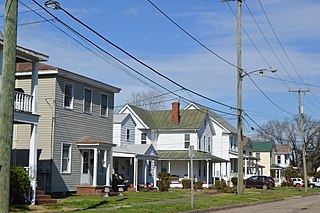
Park View Historic District is a national historic district located at Portsmouth, Virginia. It encompasses 295 contributing buildings in a primarily residential section of northeast Portsmouth. It was developed in the late-19th and early-20th centuries, and includes notable examples of Queen Anne, Colonial Revival, and American Foursquare style single family residences.

Downtown Portsmouth Historic District, also known as the High Street Corridor Historic District, is a national historic district located at Portsmouth, Virginia. It encompasses 229 contributing buildings, 1 contributing site, 4 contributing structures, and 1 contributing object in the central business district of Portsmouth. The district encompasses the original 1752 plan of the Town of Portsmouth and includes portions of expansions of the original boundaries dating to 1763 and 1909. It includes a variety of commercial, government, and institutional buildings, with most dating to the years around the turn of the 20th century. Notable buildings include the Captain Baird House, Vermillion Manor (1840), City Hall Building (1878), former United States Post Office (1907-1908), First Presbyterian Church (1877), First United Methodist Churches (1882), St. James Episcopal Church, Ebenezer Baptist Church, YMCA building, Tidewater Building, Southern Aid Building, Colony Theater, Lyric Theater, Blumberg's Department Store, Mutual Drug Company (1946), the New Kirn Building, and the Professional Building. Separately listed are the Commodore Theatre, Portsmouth Courthouse, Pythian Castle, St. Paul's Catholic Church, and Trinity Episcopal Church


