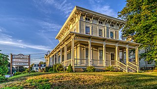
The Main Street Historic District encompasses the historic portion of the central business district of Willimantic, in Windham, Connecticut. The district encompasses the commercial business district of Willimantic and is roughly linear along Main Street and Riverside Drive between Church Street and Bridge Street. It was first listed on the National Register of Historic Places in 1982. Its area was increased in 1992 to include the Hall and Bill building on North Street, built in 1889 by one of Willimantic's leading printers.

Plainfield Street Historic District is a historic district in Plainfield, Connecticut that encompasses the historic area of Plainfield Village, the town center of Plainfield. The district is linear, being located along Route 12 between Railroad Avenue and Route 14A. It has been the center of the town's civic life since its settlement in the early 18th century, and includes two centuries of architectural styles. The district was listed on the National Register of Historic Places in 1991.
The Simsbury Center Historic District is a 75-acre (30 ha) historic district located in the town center area of Simsbury, Connecticut. It encompasses seven blocks of Hopmeadow Street, as well as the cluster of commercial, civic, and residential buildings along Railroad, Station, and Wilcox Streets, and Phelps Lane. Although its oldest element is the cemetery, most of its buildings were built in the late 19th and early 20th century. It was listed on the National Register of Historic Places in 1996.

The Huntington Center Historic District is a historic district in the city of Shelton, Connecticut. The district encompasses the original colonial settlement of Shelton, which was first known as Huntington. It is a linear district about 0.75 miles (1.21 km) in length, centered on the Huntington Green and Cemetery, and extending north along Church Street and south along Huntington Street. The district is predominantly residential, although it has two churches. The green was laid out in 1717, and many of the district's historic buildings were built over the next 150 years. The district's oldest building is a house with an estimated construction date of 1710. The district was listed on the National Register of Historic Places in 2000.
The Round Hill Historic District encompasses the village center of Round Hill, a formerly rural area in northwestern Greenwich, Connecticut. Centered on the junction of John Street and Round Hill Road, the district includes a church, cemetery, two houses, and a former district school, the latter dating to 1750. Established as a center for local farmers in the 18th century, it was transformed in the early 20th century into a center for suburban and summer estate residents. The district was listed on the National Register of Historic Places in 1996.

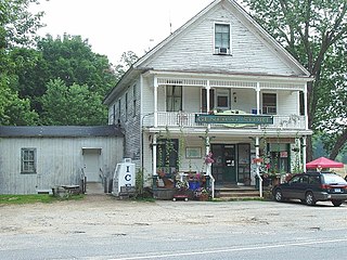
The Flanders Historic District is a historic district that encompasses a small cluster of late-18th to early-19th century residential structures north of the center of Kent, Connecticut, which was the original heart of the community when it was first settled. It is centered at the junction of United States Route 7 with Cobble Road and Studio Hill Road. The area was supplanted by the current town center in the 1840s. The district was listed on the National Register of Historic Places in 1979.

The Shrewsbury Historic District encompasses the historic early center of the town of Shrewsbury, Massachusetts. It consists of the town common, laid out in 1721 at what are now Main and Prospect Streets, and buildings adjacent or nearby. The district was declared locally in 1972, and was added to the National Register of Historic Places in 1976.

The Brimfield Center Historic District is a historic district encompassing the historic center of Brimfield, Massachusetts. The district is centered on the town common, and includes properties radiating out from that center on Main Street, Brookfled, Wales, Sturbridge and Warren Roads. Brimfield Center was first laid out in 1721 along a Native American trail that ran through the area, and developed over the years into what is now US Route 20, or Main Street. The district includes properties ranging from early colonial houses to the town hall, built in 1878. The center has retained some coherence because the Brimfield Fair, a major antiques market that takes place three times a year, takes up significant open space in the areas near the center. The district was listed on the National Register of Historic Places in 2006.

The Bedford Center Historic District encompasses the historic heart of the town of Bedford, Massachusetts. It extends along Great Road between Bacon and Concord Roads, and includes primarily residential areas on adjacent side streets. The area includes the town's main civic buildings, its first cemetery, and a diverse array of residential architecture spanning more than two centuries. The district was listed on the National Register of Historic Places in 1977; its boundaries were adjusted in 2014 and its period of significance extended.

The Brookline Town Green Historic District encompasses the historic colonial heart of the town of Brookline, Massachusetts. Centered on a stretch of Walnut Street between Warren and Chestnut Streets, this area is where the town's first colonial meeting house and cemetery were laid out, and was its center of civic life until the early 19th century. The district was listed on the National Register of Historic Places in 1980.

The Main Street Historic District encompasses the historic civic, commercial, and residential center of Durham, Connecticut. The district is primarily linear and runs along Main Street from between Higganum Road and Town House Road in the south to Talcott Lane in the north, and along Maple Avenue, which parallels Main Street. The district includes most of its colonial architecture, as well as many of its civic buildings. It was listed on the National Register of Historic Places in 1986.

The Torringford Street Historic District is a historic district on the east side of the city of Torrington, Connecticut. The district includes properties along Torringford Street, the main thoroughfare of the Torringford section of the city, between United States Route 202 and West Hill Road. The road is one of the oldest in Torrington, and this section is notable for containing a cross-section of well-preserved architecture from the 18th to the mid-20th centuries. The district was listed on the National Register of Historic Places in 1991.
The Mansfield Center Historic District encompasses the historic early village center of Mansfield, Connecticut. First settled about 1692, it is one of the oldest settlements in Tolland County, and retains a strong sense of 18th century colonial layout. It extends along Storrs Street extending from Chaffeeville Road in the north to Centre Street in the south, and was listed on the National Register of Historic Places in 1972.

The Hancock Village Historic District encompasses the town center of Hancock, New Hampshire. It extends the length of Hancock's Main Street, from Pine Ridge Cemetery and the common to the west, and the junction of Bennington, Norway Hill, and Forest roads to the east. It then extends a short way up Bennington Road. The common was laid out in 1785, and the village developed nearby over the next 100+ years. The district was listed on the National Register of Historic Places in 1988.

The Peacham Corner Historic District encompasses much of the historic village center of Peacham, Vermont. The village's period of greatest growth and importance between the town's founding as a hill town in the late 18th century, and 1860, when significant development effectively ended. As a result, the village lacks Victorian features often found in other rural communities. The district was listed on the National Register of Historic Places in 2003.

The Watertown Center Historic District encompasses the historic village center of Watertown, Connecticut. It exhibits architectural and historic changes from the early 1700s into the 20th century. It is roughly bounded by Main, Warren, North, Woodbury, Woodruff, and Academy Hill Roads, and was listed on the National Register of Historic Places in 2001.

The Enfield Historic District encompasses a two-mile stretch of Enfield Street, the main north-south road of Enfield, Connecticut. Centered on the town common with its church and old town hall, it includes a diversity of residential architecture from the 18th to early 20th centuries. The district was listed on the National Register of Historic Places in 1979.

The Rocky Hill Center Historic District encompasses the traditional town center and surrounding residential area of Rocky Hill, Connecticut. It extends along Old Main Street from the Wethersfield line southward to a triangular area bounded by Old Main, Riverview Road, and Glastonbury Avenue. Included in a basically 19th-century streetscape are the town's principal civic and religious buildings, as well as a fine collection of mainly 18th and 19th-century residential architecture. The district was listed on the National Register of Historic Places in 2007.

The Palisado Avenue Historic District encompasses a predominantly residential streetscape in northeastern Windsor, Connecticut. Extending along Palisado Avenue between the Farmington River and Bissell Ferry Road, it is a basically 18th-century street view, populated mainly with houses from the 18th to the 20th centuries. The district was listed on the National Register of Historic Places in 1987.

The Westbrook Town Center Historic District encompasses the historic town center of Westbrook, Connecticut. Roughly linear in shape, the district extends along the Boston Post Road, with its focal center at the junction with Essex Road. The area has been a center of civic activity since the early 18th century, even though Westbrook was not incorporated until 1840, and has residential, commercial, civic, and religious architecture covering three centuries. The district was listed on the National Register of Historic Places in 2017.