
Prescott is a city and the county seat of Nevada County, Arkansas, United States. The community had a population of 3,296 at the 2010 census. Prescott is part of the Hope Micropolitan Statistical Area.

Crown Hill National Cemetery is a U.S. National Cemetery located in Indianapolis, Marion County, Indiana. It was established in 1866 on Section 10 within Crown Hill Cemetery, a privately owned cemetery on the city's northwest side. Administered by the United States Department of Veterans Affairs, the National Cemetery encompasses 1.4 acres (0.57 ha) and serves as a burial site for Union soldiers who fought in the American Civil War.

Toowong Cemetery is a heritage-listed cemetery on the corner of Frederick Street and Mt Coot-tha Road, Toowong, City of Brisbane, Queensland, Australia. It was established in 1866 and formally opened in 1875. It is Queensland's largest cemetery and is located on forty-four hectares of land at the corner of Frederick Street and Mount Coot-tha Road approximately four and a half kilometres west of Brisbane. It was previously known as Brisbane General Cemetery. It was added to the Queensland Heritage Register on 31 December 2002.

Magnolia Cemetery is a historic city cemetery located in Mobile, Alabama. Filled with many elaborate Victorian-era monuments, it spans more than 100 acres (40 ha). It served as Mobile's primary, and almost exclusive, burial place during the 19th century. It is the final resting place for many of Mobile's 19th- and early 20th-century citizens. The cemetery is roughly bounded by Frye Street to the north, Gayle Street to the east, and Ann Street to the west. Virginia Street originally formed the southern border before the cemetery was expanded and now cuts east–west through the center of the cemetery. Magnolia contains more than 80,000 burials and remains an active, though very limited, burial site today.

Hillside Cemetery is a historic cemetery on West Main Street between Brown Street and Charles Street in North Adams, Massachusetts, United States. Located on the western fringe of the city, the earliest portions of the cemetery date to 1798; it is the community's oldest public burying ground. The cemetery is divided by Route 2, with the older section to the north and the younger section to the south. The cemetery's location at the foot of Mount Greylock gives it excellent views of the surrounding area, and of the urban core of North Adams.
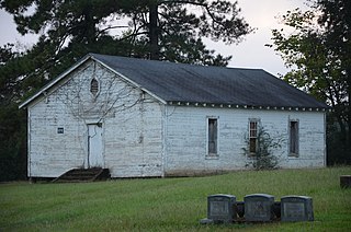
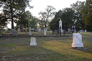
Moscow Methodist Church and Cemetery is a historic landmark built in 1864 and added to the National Register in 2006. The former community of Moscow is located just outside the current city limits of Prescott, Arkansas. The area is on or near the old "Moscow-Camden Road", or "Wire Road" which ran between Moscow and Camden, Arkansas. As of 2016, the location was known as the junction of Nevada County Roads 23 and 260.

Swampscott Cemetery is a historic cemetery at 400 Essex Street in Swampscott, Massachusetts. It is the town's only cemetery, and was established in 1852, not long after the town's incorporation. About 20 acres (8.1 ha) of the cemetery's 30 hectares have been listed on the National Register of Historic Places. Its historic portion is a representative of the rural cemetery movement that was popular in the 19th century, with meandering lanes and natural landscaping.

The Pioneer and Military Memorial Park is the official name given to seven historic cemeteries in Phoenix, Arizona. The cemeteries were founded in 1884 in what was known as "Block 32". On February 1, 2007, "Block 32" was renamed Pioneer and Military Memorial Park. The Pioneer and Military Memorial Park is listed in the National Register of Historic Places. The historic Smurthwaite House, which is also listed in the National Register of Historic Places, is located on the grounds of the Pioneer and Military Memorial Park and is used as the cemetery's main office. Pioneer and Military Memorial Park is the final resting place of various notable pioneers of Arizona.
The Mound Cemetery is a historic cemetery, located just outside Arkansas City, Arkansas in Desha County. The oldest portion of the cemetery, dating to the 1860s, is located on top of a Mississippian culture mound, one of the few places the early American settlers of the area found to be safe from periodic flooding by the Mississippi River. It is located off County Road 351, about one-half mile outside Arkansas City, and about 3 miles (4.8 km) from the river.
The Scotland Cemetery is a historic cemetery in Scotland, an unincorporated community in rural Union County, Arkansas. It is located about 3 miles (4.8 km) west of Junction City, off US Route 167 south of the Scotland Presbyterian Church. The cemetery was formally established in 1861, but had been used as a burying ground since the first settlers arrived in the area in the 1840s. It is the only tangible remnant of the community's early days; the nearby church is the third to stand on the site. The earliest grave with a known date is 1842; the cemetery has more than 30 unmarked graves, including some that are probable graves of slaves.

Oakland Cemetery is a historic cemetery in Camden, Arkansas, located on Maul Road between Pearl Street and Madison Avenue. Established in 1830, it is the city's oldest cemetery. It consists of just over 7 acres (2.8 ha) of land donated in that year by William L. Bradley, one of Camden's founders. It is the burial site of many of Camden's leading citizens. Among them is James Thomas Elliott (1823–1875), a former Confederate soldier who represented Arkansas's 2nd District as a Republican.
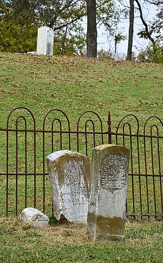
The Helena Confederate Cemetery is located in the southwest corner of the Maple Hill Cemetery on Holly Street in Helena, Arkansas. It is a small section of the larger cemetery, under one acre in size, and is marked by two significant memorials: the Confederate Memorial and the memorial to Confederate Army General Patrick Cleburne, whose burial here is the only known place associated with his life. The Cleburne memorial is a marble shaft 15 feet (4.6 m) in height, topped by an urn with flames coming from its top. The Confederate Memorial is a marble depiction of a soldier, mounted on a 30-foot (9.1 m) granite shaft, surrounded by pyramids of cannonballs and inverted cannons. The cemetery has more than 100 marked graves, 15 of which are unidentified Confederate dead, and 23 are of those killed in the 1863 Battle of Helena.

Fairview Cemetery, also known as the Van Buren Cemetery, is a historic cemetery on the east side of Arkansas Highway 59 in Van Buren, Arkansas. The 10-acre (4.0 ha) cemetery's oldest graves date to 1816, the period of the region's settlement, and include some of Van Buren's first settlers. First established as an informal private burial ground, it was given to the city by John Drennen in 1846.
Fredonia Cemetery, also known as Holly Grove Cemetery and Stevens Creek Cemetery, is a cemetery in rural White County, Arkansas, northwest of Bald Knob on Fredonia Road. The oldest portion of the cemetery houses marked graves with the oldest dating to 1870, and is estimated to contain at least 300 unmarked graves. The cemetery houses many of the area's early settlers.

The Hollywood Cemetery is the oldest cemetery in Hot Springs, Arkansas. The cemetery was established sometime prior to the American Civil War, with its oldest marked grave dating to 1856. It is located southeast of downtown Hot Springs, and is bounded by Hollywood Avenue, Mote Street, and Shady Grove Road. Its Confederate Section, located in the northeastern part of the cemetery, commemorates the city's Civil War Confederate Army soldiers, and contains 34 marked burials. At the center of that area is an 8-foot (2.4 m) granite monument in which is a marble marker inscribed "OUR CONFEDERATE DEAD". The Confederate section of the cemetery was listed on the National Register of Historic Places in 1996.

The Prairie Grove Cemetery is a historic cemetery on West Buchanan and Kate Smith Streets in Prairie Grove, Washington County, Arkansas. Located just west of downtown Prairie Grove, the cemetery is the burial ground for many of the area's early settlers, with the oldest known burial occurring in 1818. It has more than 3,000 interments, and continues in active use. It is owned and maintained by a private not-for-profit cemetery association.

Oak Grove Cemetery is the oldest cemetery of the city of Conway, Arkansas. It was established in 1880, five years after the town was incorporated and nine after its first settlement. The cemetery is in active use, with more than 3,000 burials. Among the interred are many of the city's earliest and most prominent citizens.

Brearley Cemetery, founded in 1847, is the oldest cemetery in the city of Dardanelle, Arkansas. It is located on the north side of Arkansas Highway 27, west of its junction with Arkansas Highway 22. The cemetery, still in active use, houses more than 2,000 burials, many of the descendants of the early Czech immigrants to the area. One marker, possibly a memorial marker, bears the date 1780, but its provenance and significance has not been established. A 15-acre (6.1 ha) section on the eastern side of the cemetery, where its oldest burials are located, was listed on the National Register of Historic Places in 2007.
The Martin Cemetery is a historic cemetery on the northern frontage road of Interstate 30 in the Mabelvale section of southwestern Little Rock, Arkansas. The cemetery is 6.5 acres (2.6 ha) in size, and had more than 1300 burials as of 2017. The cemetery's oldest burials date to 1833, and consist of members of the Martin family, early settlers and surveyors of the area. The oldest portion of the cemetery, a 2-acre (0.81 ha) rectangular area located in its southeast, was listed on the National Register of Historic Places in 2017, for its association with the region's early history.


