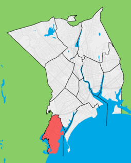
Black Rock is a neighborhood in the southwestern section of the city of Bridgeport, Connecticut. It borders Fairfield and the Ash Creek tidal estuary on the west, the West Side/West End of Bridgeport on the north and east, and Black Rock Harbor and Long Island Sound on the south. Black Rock comprises census tracts 701 and 702 and part of census tract 703. It includes two historic districts listed on the National Register of Historic Places. Residences comprise 86% of properties in Black Rock, 10% are commercial, and 4% are industrial or other property classes.

The Main Street Historic District in Danbury, Connecticut, United States, is the oldest section of that city, at its geographical center. It has long been the city's commercial core and downtown. Its 132 buildings, 97 of which are considered contributing properties, include government buildings, churches, commercial establishments and residences, all in a variety of architectural styles from the late 18th century to the early 20th. It is the only major industrial downtown of its size in Connecticut not to have developed around either port facilities or a water power site.

The Hotchkissville Historic District is a historic district in the town of Woodbury, Connecticut, that was listed on the National Register of Historic Places in 1995. The district encompasses most of the historic village of Hotchkissville, which is centered at the junction of Washington and Weekeepeemee roads. The village began as a dispersed rural agricultural community, but developed in the 19th century with the arrival of industry, primarily the manufacture of textiles. Despite this, the village has retained a significantly rural character, and includes a broad cross-section of 18th- and 19th-century architectural styles.

This is a list of the National Register of Historic Places listings in Detroit, Michigan.

The Winchester Repeating Arms Company Historic District is a historic district in New Haven, Connecticut that was listed on the National Register of Historic Places in 1988. It includes 867 properties, which "include 858 major structures and 131 notable outbuildings." Of these structures, 876 are buildings deemed to contribute to the historical and/or architectural significance of the area, and most of these are residential. However the center of the district is "dominated" by the 75-acre (30 ha) tract of the former Winchester Repeating Arms Company, which contains industrial buildings.

The Fort Street–Pleasant Street and Norfolk & Western Railroad Viaduct is a bridge carrying six lanes of Fort Street over both Pleasant Street and multiple tracks comprising the Norfolk Southern Railway Detroit District and Conrail Shared Assets Lincoln Secondary and Junction Yard Secondary lines on the border of the Boynton and Oakwood Heights neighborhoods in Detroit, Michigan, just west of the Rouge River. It was listed on the National Register of Historic Places in 2000. The bridge underwent massive repairs and other construction in late 2010 and throughout much of 2011, which included narrowing the Fort Street boulevard north of the viaduct into a six-lane undivided road with a left-turns-only lane.

The Junction Shop and Hermon Street District is a historic district comprising 28 industrial properties on Jackson, Hermon, and Beacon Streets on the south side of Worcester, Massachusetts. It is a remnant of a once larger 19th and early 20th century manufacturing district just west of the railway junction between the Boston and Maine Railroad and the New York, New Haven and Hartford Railroad. It was listed on the National Register of Historic Places in 1980.

The University-Cultural Center MRA is a pair of multiple property submissions to the National Register of Historic Places which were approved on April 29 and May 1, 1986. The structures included are all located in Midtown, near Woodward Avenue and Wayne State University in Detroit, Michigan. The two submissions are designated the University-Cultural Center MRA Phase I, containing five properties, and the University-Cultural Center MRA Phase II, containing three properties.

There are nine historic districts in Meridian, Mississippi. Each of these districts is listed on the National Register of Historic Places. One district, Meridian Downtown Historic District, is a combination of two older districts, Meridian Urban Center Historic District and Union Station Historic District. Many architectural styles are present in the districts, most from the late 19th century and early 20th century, including Queen Anne, Colonial Revival, Italianate, Art Deco, Late Victorian, and Bungalow.

Bridgeport is a historic seaport city in the U.S. state of Connecticut, and its largest city. With a population of 148,654 in 2020, it is also the fifth-most populous in New England. Located in Fairfield County at the mouth of the Pequonnock River on Long Island Sound, it is 60 miles (97 km) from Manhattan and 40 miles (64 km) from The Bronx. It is bordered by the towns of Trumbull to the north, Fairfield to the west, and Stratford to the east. Bridgeport and other settlements in Fairfield County make up the Bridgeport-Stamford-Norwalk-Danbury metropolitan statistical area, the second largest metropolitan area in Connecticut. The Bridgeport-Stamford-Norwalk-Danbury metropolis forms part of the New York megacity.

The West Side Historic District is a residential area of Saratoga Springs, New York, United States, located west of its downtown section. It is a 122-acre (49 ha) area extending from the blocks west of Broadway to extensions along Church and Washington streets. The former Franklin Square Historic District is included in its entirety.

Bassickville Historic District is a historic district encompassing a well-preserved late 19th-century residential development on the west side of Bridgeport, Connecticut. Located on Bassick, Howard, and Fairview Avenues, the area was developed as a residential subdivision of worker housing by Edmund Bassick. The development is characterized by nearly identical 1-1/2 story frame cottages exhibiting the Stick style of architecture. The district was listed on the National Register of Historic Places in 1987.
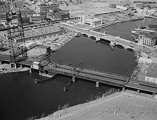
The Pequonnock River Railroad Bridge is a railroad drawbridge over the Pequonnock River in Bridgeport, Connecticut. Owned by the State of Connecticut and maintained and operated by both Amtrak and Metro-North Railroad, it is also referred to as Pequonnock River Bridge, PECK Bridge, and Undergrade Bridge 55.90. Currently the bridge is part of the Northeast Corridor line, carrying rail traffic of Amtrak and Metro-North, as well as freight trains operated by the Providence & Worcester Railroad.

The Broadway–Livingston Avenue Historic District is located at the junction of those two streets in Albany, New York, United States. It includes seven buildings remaining from an original 20, all contributing properties, and a Warren truss railroad bridge. In 1988 the area was recognized as a historic district and listed on the National Register of Historic Places.

The Bridgeport Downtown North Historic District encompasses a portion of the commercial downtown of Bridgeport, Connecticut. It isroughly bounded on the north by Congress Street, the east by Water and Middle Streets, the south by Fairfield Avenue, and the west by Lyon Terrace, roughly the northeastern quadrant of the downtown area. It is one of two large clusters of historically significant commercial and civic buildings encapsulating the city's growth as an urban industrial and regional government center. It was listed on the National Register of Historic Places in 1987.

The Division Street Historic District encompasses one of the best-preserved 19th-century residential areas of Bridgeport, Connecticut. Now separated from downtown Bridgeport by the Connecticut Route 25 highway, the area includes a cross-section of 19th-century architectural styles, as well as a diversity of sophistication, from working-class accommodations to high-style Victorian mansions. The district was listed on the National Register of Historic Places in 1982.

The East Bridgeport Historic District encompasses one of the best-preserved 19th-century neighborhoods of Bridgeport, Connecticut. Bounded by Arctic Street, East Main Street, the railroad tracks, and the Pequonnock River, this area was a planned development of Bridgeport promoter P.T. Barnum and landowner William H. Noble. Its development prompted the significant growth of industry and economic activity east of the Pequonnock River. The district was listed on the National Register of Historic Places in 1979.

The East Main Street Historic District encompasses a well-preserved late 19th-century commercial area on the east side of Bridgeport, Connecticut. Extending along East Main Street from Interstate 95 to Crescent Place, the district arose as part of a major development push orchestrated by P.T. Barnum in the 1850s, and contains one of Connecticut's finest assemblages of late Victorian commercial architecture. The district was listed on the National Register of Historic Places in 1985.

The Marina Park Historic District encompasses the finest collection of high-style late 19th-century residential architecture in the city of Bridgeport, Connecticut. Extending along Park Avenue between Seaside Park and Atlantic Avenue, this area was home to Bridgeport's industrial and civic leaders, and was developed by city booster P.T. Barnum. The district was listed on the National Register of Historic Places in 1982.
Riverside–11th Street Bridge is a district in the northeastern section of Wilmington, Delaware.
