Rattlesnake Creek (Kansas)

Last updated
Rattlesnake Creek
Salt Creek
Rattlesnake Creek at Zenith KS.jpg
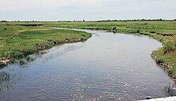
Rattlesnake Creek near Zenith, Kansas
Location
Country United States
State Kansas
Region High Plains
Physical characteristics
Source 
  locationNear Kiowa, High Plains, Kansas, United States
  coordinates 37°28′30″N099°46′35″W / 37.47500°N 99.77639°W / 37.47500; -99.77639 [1]
  elevation1,729 ft (527 m)
Mouth Arkansas River
  location
Near Sterling, Kansas, United States
  coordinates
38°12′59″N098°30′00″W / 38.21639°N 98.50000°W / 38.21639; -98.50000 [1]
  elevation
527 ft (161 m) [1]
Length95 mi (153 km), Northeast-Southwest [1]
Basin features
River system Arkansas River watershed

Rattlesnake Creek is an approximately 95 mile stream that is a tributary to the Arkansas River in central Kansas. [2] The head of the stream is in northern Kiowa County and it flows northeast through Edwards and Stafford Counties before converging with the Arkansas River in Rice County. The stream flows through Quivira National Wildlife Refuge dividing the refuge in half. The stream was officially named Rattlesnake Creek in 1971 by the Department of Interior; before 1971 it was called either Rattlesnake Creek, Salt Creek, or West Fork Rattlesnake Creek. [2]

See also

Related Research Articles

<span class="mw-page-title-main">Republican River</span> River in Colorado, United States

The Republican River is a river in the central Great Plains of North America, rising in the High Plains of eastern Colorado and flowing east 453 miles (729 km) through the U.S. states of Nebraska and Kansas.

<span class="mw-page-title-main">Honeoye Creek</span> River in New York, United States

Honeoye Creek is a tributary of the Genesee River in western New York in the United States. The name Honeoye is from the Seneca word ha-ne-a-yah, which translates to "lying finger", or "where the finger lies". The name refers to the local story of a Native American who had his finger bitten by a rattlesnake and therefore cut off his finger with a tomahawk.

<span class="mw-page-title-main">Marais des Cygnes River</span> River in Missouri, United States

The Marais des Cygnes River is a principal tributary of the Osage River, about 217 miles (349 km) long, in eastern Kansas and western Missouri in the United States. Via the Osage and Missouri rivers, it is part of the watershed of the Mississippi River.

<span class="mw-page-title-main">Whitewater River (Kansas)</span> River in Kansas, United States

The Whitewater River is a 62-mile-long (100 km) tributary of the Walnut River in southern Kansas in the United States. Via the Walnut and Arkansas Rivers, it is part of the watershed of the Mississippi River.

<span class="mw-page-title-main">Salt Fork Arkansas River</span> River in the United States

The Salt Fork of the Arkansas River is a 239-mile-long (385 km) tributary of the Arkansas River in southern Kansas and northern Oklahoma in the United States. Via the Arkansas River, it is part of the watershed of the Mississippi River.

<span class="mw-page-title-main">Chikaskia River</span> River in the United States

The Chikaskia River is a 159-mile-long (256 km) tributary of the Salt Fork of the Arkansas River in southern Kansas and northern Oklahoma in the United States. Via the Salt Fork and Arkansas rivers, it is part of the watershed of the Mississippi River.

<span class="mw-page-title-main">Medicine Lodge River</span> River in the United States

The Medicine Lodge River is a 130-mile-long (210 km) tributary of the Salt Fork of the Arkansas River in southern Kansas and northern Oklahoma in the United States. Via the Salt Fork and Arkansas rivers, it is part of the watershed of the Mississippi River.

Rattlesnake Creek is a tributary of Paint Creek, 42.3 miles (68.1 km) long, in south-central Ohio in the United States. Via Paint Creek and the Scioto and Ohio Rivers, it is part of the watershed of the Mississippi River, draining an area of 277 square miles (720 km2). According to the Geographic Names Information System, it has also been known historically as "Rattlesnake Fork."

<span class="mw-page-title-main">North Fork River (Missouri–Arkansas)</span> River in Arkansas and Missouri, United States

The North Fork River or the North Fork of White River is a 109-mile-long (175 km) tributary of the White River, into which it flows near Norfork, Arkansas.

<span class="mw-page-title-main">Redbank Creek (Pennsylvania)</span> River in Pennsylvania, United States

Redbank Creek is a tributary of the Allegheny River in Clarion, Armstrong, and Jefferson counties, Pennsylvania in the United States.

<span class="mw-page-title-main">Cow Creek (Kansas)</span> River in Kansas, United States

Cow Creek is a 112-mile-long (180 km) stream that flows through Rice and Reno Counties, Kansas. Cow Creek is a tributary of the Arkansas River; its confluence with the Arkansas is about ten miles southeast of Hutchinson, Kansas.

<span class="mw-page-title-main">Middle Fork Willamette River</span> River in Oregon, United States

The Middle Fork Willamette River is one of several forks that unite to form the Willamette River in the western part of the U.S. state of Oregon. It is approximately 115 miles (185 km) long, draining an area of the Cascade Range southeast of Eugene, which is at the southern end of the Willamette Valley.

<span class="mw-page-title-main">Little River (Red River tributary)</span> River in Oklahoma and Arkansas, United States

The Little River is a tributary of the Red River, with a total length of 217 miles (349 km), 130 miles (210 km) within the Choctaw Indian Reservation in southeastern Oklahoma and 87 miles (140 km) in southwestern Arkansas in the United States. Via the Red, it is part of the watershed of the Mississippi River. Six large reservoirs impound the Little River and its tributaries. The drainage basin of the river totals 4,204 square miles (10,890 km2), 2,204 square miles (5,710 km2) in Oklahoma and 2,036 square miles (5,270 km2) in Arkansas. The Little River and its upper tributaries are popular for recreational canoeing and kayaking.

<span class="mw-page-title-main">Cheyenne Bottoms</span>

Cheyenne Bottoms is a wetland in the central Great Plains of North America. Occupying approximately 41,000 acres in central Kansas, it is the largest wetland in the interior United States. The Bottoms is a critical stopping point on the Central Flyway for millions of birds which migrate through the region annually.

Coldwater Creek is an intermittently-flowing stream in northeastern New Mexico, and the panhandles of Oklahoma and Texas. As far back as 1907, the USGS reported that Coldwater Creek is a dry sand bed most of the year. One source says that Coldwater Creek is also known as Rabbit Ears Creek, because it rises near Rabbit Ears, a pair of mountain peaks in Union County, New Mexico. According to the United States Geological Survey (USGS), Coldwater Creek drains an area of 1,903 square miles (4,930 km2).

The Pawnee River or Pawnee Fork is a river in western Kansas in the United States, about 198 miles (319 km) long. It is a tributary of the Arkansas River, which in turn is a branch of the Mississippi River.

Bear Creek is a tributary of the Arkansas River and has its headwaters in Baca County, Colorado. It flows through Baca County into Kansas and through Stanton and Grant Counties and into Kearny County where it converges with the Arkansas River about 8 miles southwest of Lakin, Kansas.

<span class="mw-page-title-main">Prairie Dog Creek</span> River in Nebraska, United States

Prairie Dog Creek is a stream in the central Great Plains of North America. A tributary of the Republican River, it flows for 246 miles (396 km) through the American states of Kansas and Nebraska.

<span class="mw-page-title-main">Sappa Creek</span> River in Nebraska, United States

Sappa Creek is a stream in the central Great Plains of North America. A tributary of the Republican River, it flows for 150 miles (240 km) through the American states of Kansas and Nebraska.

References

  1. 1 2 3 4 "Rattlesnake Creek". Geographic Names Information System . United States Geological Survey, United States Department of the Interior. 1978-10-13. Retrieved 2013-08-16.
  2. 1 2 "U.S. Board on Geographic Names".