The Columbia River is the largest river in the Pacific Northwest region of North America. The river rises in the Rocky Mountains of British Columbia, Canada. It flows northwest and then south into the US state of Washington, then turns west to form most of the border between Washington and the state of Oregon before emptying into the Pacific Ocean. The river is 1,243 miles (2,000 km) long, and its largest tributary is the Snake River. Its drainage basin is roughly the size of France and extends into seven US states and a Canadian province. The fourth-largest river in the United States by volume, the Columbia has the greatest flow of any North American river entering the Pacific.

The Snake River is a major river of the greater Pacific Northwest region in the United States. At 1,078 miles (1,735 km) long, it is the largest tributary of the Columbia River, in turn the largest North American river that empties into the Pacific Ocean. The Snake River rises in western Wyoming, then flows through the Snake River Plain of southern Idaho, the rugged Hells Canyon on the Oregon–Idaho border and the rolling Palouse Hills of Washington, emptying into the Columbia River at the Tri-Cities, Washington.
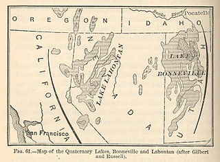
Lake Bonneville was a prehistoric pluvial lake that covered much of the eastern part of North America's Great Basin region. Most of the territory it covered was in present-day Utah, though parts of the lake extended into present-day Idaho and Nevada. Lake Bonneville existed until about 14,500 years ago, when a large portion of the lake was released through the Red Rock Pass in Idaho. Following the Bonneville flood, as the release is now known, the lake receded to a level called the Provo Level. Many of the unique geological characteristics of the Great Basin are due to the effects of the lake.
Lake breakout is the collapse of a lake, usually of high-altitude. High-altitude lakes tend to form in volcanic craters – where they are called crater lakes – or in valleys dammed as the result of earthquakes or glacial or volcanic deposition. Lake breakouts are most common a few weeks or months after a volcanic eruption as a river becomes blocked by volcanic debris.

Henrys Fork is a tributary river of the Snake River, approximately 127 miles (204 km) long, in southeastern Idaho in the United States. It is also referred to as the North Fork of the Snake River. Its drainage basin is 3,212 square miles (8,320 km2), including its main tributary, the Teton River. Its mean annual discharge, as measured at river mile 9.2 by the United States Geological Survey (USGS), is 2,096 cubic feet per second (59.4 m3/s), with a maximum daily recorded flow of 79,000 cubic feet per second (2,240 m3/s), and a minimum of 183 cubic feet per second (5.18 m3/s).
In geomorphology, an outburst flood — a type of megaflood — is a high-magnitude, low-frequency catastrophic flood involving the sudden release of a large quantity of water. During the last deglaciation, numerous glacial lake outburst floods were caused by the collapse of either ice sheets or glaciers that formed the dams of proglacial lakes. Examples of older outburst floods are known from the geological past of the Earth and inferred from geomorphological evidence on Mars. Landslides, lahars, and volcanic dams can also block rivers and create lakes, which trigger such floods when the rock or earthen barrier collapses or is eroded. Lakes also form behind glacial moraines, which can collapse and create outburst floods.
The Bear River is the largest tributary of the Great Salt Lake, draining a mountainous area and farming valleys northeast of the lake and southeast of the Snake River Plain. It flows through southwestern Wyoming, southeastern Idaho, and northern Utah, in the United States. Approximately 350 miles (560 km) long it is the longest river in North America that does not ultimately reach the sea.

The Portneuf River is a 124-mile-long (200 km) tributary of the Snake River in southeastern Idaho, United States. It drains a ranching and farming valley in the mountains southeast of the Snake River Plain. The city of Pocatello sits along the river near its emergence from the mountains onto the Snake River Plain.

The City of Rocks National Reserve, also known as the Silent City of Rocks, is a United States National Reserve and state park lying 2 miles (3.2 km) north of the south central Idaho border with Utah. It is widely known for its excellent rock climbing and rock formations.

A geologic hazard is one of several types of adverse geologic conditions capable of causing damage or loss of property and life. These hazards consist of sudden phenomena and slow phenomena:

The Palouse River is a tributary of the Snake River in Washington and Idaho, in the northwest United States. It flows for 167 miles (269 km) southwestwards, primarily through the Palouse region of southeastern Washington. It is part of the Columbia River Basin, as the Snake River is a tributary of the Columbia River.
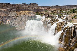
Shoshone Falls is a waterfall on the Snake River in southern Idaho, United States, approximately 3 miles (4.8 km) northeast of the city of Twin Falls. Sometimes called the "Niagara of the West," Shoshone Falls is 212 feet (65 m) high—45 feet (14 m) higher than Niagara Falls—and flows over a rim nearly 1,000 feet (300 m) wide.

The Morley Nelson Snake River Birds of Prey National Conservation Area has one of the densest populations of nesting raptors. The National Conservation Area (NCA) is located 35 miles (56 km) south of Boise, Idaho along 81 miles (130 km) of the Snake River, and is managed by the Bureau of Land Management. The NCA covers 484,873 acres (1,962.21 km2). In descending order of land area it is located in Ada, Elmore, Owyhee, and Canyon counties.

Wallula Gap is a large water gap of the Columbia River through the Horse Heaven Hills basalt anticlines in the Columbia River Basin in the U.S. state of Washington, just south of the confluence of the Walla Walla and Columbia rivers. It has been recognized as a National Natural Landmark by the National Park Service as a site that provides an important illustration of the geological history of the United States.

Hell's Half Acre Lava Field is a basaltic lava plain located on the Snake River Plain of Idaho in the United States. It is the easternmost of the basaltic lava fields on the Snake River Plain, located about 25 miles (40 km) west of Idaho Falls, Idaho and 30 miles (48 km) north of Pocatello, Idaho. In 1976, the National Park Service designated the northwestern portion of the site a National Natural Landmark. In 1986, the Bureau of Land Management recommended that 68,760 acres (27,830 ha) of the site, located just southeast of the National Natural Landmark, to be a wilderness study area.

Lake Lewis was a temporary lake in the Pacific Northwest region of North America, largely formed by the Missoula Floods in about the 14th millennium B.C.
Interstate 15 (I-15) is a part of the Interstate Highway System that runs from San Diego, California, to Sweetgrass, Montana. In Idaho, the Interstate Highway runs exactly 196 miles (315 km) from the Utah state line near Woodruff north to the Montana state line at Monida Pass. I-15 is the primary north–south highway of Eastern Idaho. The Interstate Highway connects Pocatello and Idaho Falls, the fourth and fifth largest cities in Idaho, and the smaller county seats of Malad City, Blackfoot, and Dubois. I-15 connects all of those cities with Salt Lake City to the south and Butte to the north. The Interstate has business loops through McCammon, Inkom, Pocatello, Blackfoot, and Idaho Falls.

The Northern Basin and Range ecoregion is a Level III ecoregion designated by the United States Environmental Protection Agency (EPA) in the U.S. states of Oregon, Idaho, Nevada, Utah, and California. It contains dissected lava plains, rolling hills, alluvial fans, valleys, and scattered mountain ranges in the northern part of the Great Basin. Although arid, the ecoregion is higher and cooler than the Snake River Plain to the north and has more available moisture and a cooler climate than the Central Basin and Range to the south. Its southern boundary is determined by the highest shoreline of Pleistocene Lake Bonneville, which once inundated the Central Basin and Range. The western part of the region is internally drained; its eastern stream network drains to the Snake River system.

Salmon Falls Creek is a tributary of the Snake River, flowing from northern Nevada into Idaho in the United States. Formed in high mountains at the northern edge of the Great Basin, Salmon Falls Creek flows northwards 121 miles (195 km), draining an arid and mountainous basin of 2,103 square miles (5,450 km2). The Salmon Falls Creek valley served as a trade route between the Native American groups of the Snake River Plain and Great Basin. Today, most of its water is used for irrigation.

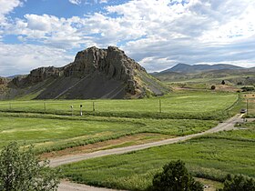
The Bonneville flood was a catastrophic flooding event in the last ice age, which involved massive amounts of water inundating parts of southern Idaho and eastern Washington along the course of the Snake River. Unlike the Missoula Floods, which also occurred during the same period in the Pacific Northwest, the Bonneville flood only happened once. The flood is believed to be the second largest in known geologic history.