Redding, Iowa

Last updated
Redding, Iowa
Redding, IA.jpg
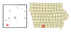
Ringgold County Iowa Incorporated and Unincorporated areas Redding Highlighted.svg
Location of Redding, Iowa
Coordinates: 40°36′18″N94°23′18″W / 40.60500°N 94.38833°W / 40.60500; -94.38833 Coordinates: 40°36′18″N94°23′18″W / 40.60500°N 94.38833°W / 40.60500; -94.38833
Country Flag of the United States.svg  United States
State Flag of Iowa.svg  Iowa
County Ringgold
Area
[1]
  Total1.00 sq mi (2.59 km2)
  Land0.99 sq mi (2.56 km2)
  Water0.01 sq mi (0.02 km2)
Elevation
[2]
1,145 ft (349 m)
Population
 (2020)
  Total63
  Density63.70/sq mi (24.58/km2)
Time zone UTC-6 (Central (CST))
  Summer (DST) UTC-5 (CDT)
ZIP code
50860
Area code 641
FIPS code 19-66000
GNIS feature ID0460563 [2]

Redding is a city in southwest Ringgold County, Iowa, United States. The population was 63 at the time of the 2020 census. [3]

Contents

Geography

Redding is located at 40°36′18″N94°23′18″W / 40.60500°N 94.38833°W / 40.60500; -94.38833 (40.605076, -94.388469). [4]

According to the United States Census Bureau, the city has a total area of 1.01 square miles (2.62 km2), of which 1.00 square mile (2.59 km2) is land and 0.01 square miles (0.03 km2) is water. [5]

Demographics

Historical populations
YearPop.±%
1880 85    
1890 214+151.8%
1900 311+45.3%
1910 269−13.5%
1920 289+7.4%
1930 272−5.9%
1940 246−9.6%
1950 200−18.7%
1960 129−35.5%
1970 111−14.0%
1980 91−18.0%
1990 119+30.8%
2000 78−34.5%
2010 82+5.1%
2020 63−23.2%
Source: "U.S. Census website". United States Census Bureau . Retrieved 2020-03-29. and Iowa Data Center
Source:
U.S. Decennial Census [6] [3]

2010 census

As of the census [7] of 2010, there were 82 people, 37 households, and 21 families living in the city. The population density was 82.0 inhabitants per square mile (31.7/km2). There were 42 housing units at an average density of 42.0 per square mile (16.2/km2). The racial makeup of the city was 100.0% White.

There were 37 households, of which 21.6% had children under the age of 18 living with them, 48.6% were married couples living together, 2.7% had a female householder with no husband present, 5.4% had a male householder with no wife present, and 43.2% were non-families. 35.1% of all households were made up of individuals, and 29.7% had someone living alone who was 65 years of age or older. The average household size was 2.22 and the average family size was 2.95.

The median age in the city was 51.5 years. 24.4% of residents were under the age of 18; 3.7% were between the ages of 18 and 24; 14.7% were from 25 to 44; 36.6% were from 45 to 64; and 20.7% were 65 years of age or older. The gender makeup of the city was 50.0% male and 50.0% female.

2000 census

As of the census [8] of 2000, there were 78 people, 35 households, and 24 families living in the city. The population density was 77.6 inhabitants per square mile (30.0/km2). There were 41 housing units at an average density of 40.8 per square mile (15.8/km2). The racial makeup of the city was 100.00% White.

There were 35 households, out of which 20.0% had children under the age of 18 living with them, 60.0% were married couples living together, 2.9% had a female householder with no husband present, and 31.4% were non-families. 25.7% of all households were made up of individuals, and 14.3% had someone living alone who was 65 years of age or older. The average household size was 2.23 and the average family size was 2.71.

In the city, the population was spread out, with 17.9% under the age of 18, 3.8% from 18 to 24, 24.4% from 25 to 44, 34.6% from 45 to 64, and 19.2% who were 65 years of age or older. The median age was 47 years. For every 100 females, there were 110.8 males. For every 100 females age 18 and over, there were 113.3 males.

The median income for a household in the city was $13,750, and the median income for a family was $36,250. Males had a median income of $24,375 versus $23,750 for females. The per capita income for the city was $10,144. There were 22.2% of families and 30.2% of the population living below the poverty line, including 15.8% of under eighteens and 40.0% of those over 64.

Education

Mount Ayr Community School District operates public schools serving the community. [9]

Related Research Articles

<span class="mw-page-title-main">Islandia, Florida</span> Unincorporated community in Florida, United States

Islandia is an unincorporated community and former city in Miami-Dade County, Florida, United States. It is located in the upper Florida Keys on the islands of Elliott Key and other nearby keys, such as Totten Key. It was the only municipality in the Florida Keys not located in neighboring Monroe County. The population was 18 at the 2010 Census. Most residents of the city were National Park Service employees.

<span class="mw-page-title-main">West Perrine, Florida</span> CDP in Florida, United States

West Perrine is a census-designated place (CDP) in Miami-Dade County, Florida, United States. Prior to the 2000 census it was part of Perrine. The other part of Perrine became the East Perrine CDP for the 2000 census and is now part of the incorporated Village of Palmetto Bay. West Perrine is still an unincorporated area, although some residents have discussed the possibility of incorporating Perrine. The population was 8,600 at the 2000 census. The name derives from a land grant issued to the heirs of Henry Perrine, an agriculturist.

<span class="mw-page-title-main">Irwin, Idaho</span> City in Idaho, United States

Irwin is a city in Bonneville County, Idaho, United States. It is part of the Idaho Falls, Idaho Metropolitan Statistical Area. The population was 219 at the 2010 census.

<span class="mw-page-title-main">Hopkins Park, Illinois</span> Village in Illinois, United States

Hopkins Park is a village in Kankakee County, Illinois, United States. The population was 603 at the 2010 census, down from 711 at the 2000 census. It is part of the Kankakee–Bradley Metropolitan Statistical Area.

<span class="mw-page-title-main">Plano, Iowa</span> City in Iowa, United States

Plano is a city in Appanoose County, Iowa, United States. The population was 59 at the time of the 2020 census.

<span class="mw-page-title-main">Maysville, Iowa</span> City in Iowa, USA

Maysville is a city in Scott County, Iowa, United States. The population was 156 at the time of the 2020 census.

<span class="mw-page-title-main">McCausland, Iowa</span> City in Iowa, USA

McCausland is a city in Butler Township, Scott County, Iowa, United States. The population was 313 at the time of the 2020 census.

<span class="mw-page-title-main">Ogema, Minnesota</span> City in Minnesota, United States

Ogema is a city in Becker County, Minnesota, United States. The population was 208 at the 2020 census.

<span class="mw-page-title-main">Leonidas, Minnesota</span> City in Minnesota, United States

Leonidas is a city in Saint Louis County, Minnesota, United States. The population was 52 at the 2010 census.

<span class="mw-page-title-main">Auburn, Nebraska</span> City in Nebraska, United States

Auburn is a city in Nemaha County, Nebraska, United States, and its county seat. The population was 3,470 at the 2020 census.

<span class="mw-page-title-main">Kathryn, North Dakota</span> City in North Dakota, United States

Kathryn is a city in Barnes County, North Dakota, United States. The population was 66 at the 2020 census. Kathryn was founded in 1900. It was named after the daughter of a railroad man.

<span class="mw-page-title-main">Stanley, North Dakota</span> City in North Dakota, United States

Stanley is a city in Mountrail County, North Dakota, United States. It is the county seat of Mountrail County. The population was 2,321 at the 2020 census, making it the 21st largest city in North Dakota. Stanley was founded in 1902. The town's economy is heavily connected to the nearby oil-rich Bakken Formation.

<span class="mw-page-title-main">Waite Hill, Ohio</span> Village in Ohio, United States

Waite Hill is a village in Lake County, Ohio, United States and an affluent rural suburb of Cleveland. The population was 471 at the 2010 census.

<span class="mw-page-title-main">Bearden, Oklahoma</span> Town in Oklahoma, United States

Bearden is a town in Okfuskee County, Oklahoma, United States. The population was 133 at the 2010 census.

<span class="mw-page-title-main">Morrison, Tennessee</span> Town in Tennessee, United States

Morrison is a town in Warren County, Tennessee, United States. The population was 684 at the 2000 census and 694 at the 2010 census.

<span class="mw-page-title-main">Soap Lake, Washington</span> City in Washington, United States

Soap Lake is a city in Grant County, Washington, on the shores of Soap Lake. The population was 1,691 at the 2020 census.

<span class="mw-page-title-main">Follansbee, West Virginia</span> City in West Virginia, United States

Follansbee is a city in Brooke County, West Virginia, United States, located along the Ohio River. It is a part of the Weirton–Steubenville metropolitan area. The population was 2,853 at the 2020 census, a decrease from 2,986 at the 2010 census.

<span class="mw-page-title-main">Auburn, West Virginia</span> Town in West Virginia, United States

Auburn is a town in Ritchie County, West Virginia, United States. The population was 80 at the 2020 census.

<span class="mw-page-title-main">Pennsboro, West Virginia</span> City in West Virginia, United States

Pennsboro is a city in Ritchie County, West Virginia, United States. The population was 1,050 at the 2020 census. The city is located at the junction of U.S. Route 50 and West Virginia Route 74; the North Bend Rail Trail also passes through the city.

<span class="mw-page-title-main">Sutherlin, Oregon</span> City in Oregon, United States

Sutherlin is a city in Douglas County, Oregon, United States. As of the 2010 Census, the population was 7,810, making it the second most populous city in Douglas County. Located off of I-5, nearby features include Cooper Creek Reservoir, Ford's pond, the Umpqua River, a golf course, and numerous vineyards.

References

  1. "2020 U.S. Gazetteer Files". United States Census Bureau. Retrieved March 16, 2022.
  2. 1 2 U.S. Geological Survey Geographic Names Information System: Redding, Iowa
  3. 1 2 "2020 Census State Redistricting Data". census.gov. United states Census Bureau. Retrieved 12 August 2021.
  4. "US Gazetteer files: 2010, 2000, and 1990". United States Census Bureau. 2011-02-12. Retrieved 2011-04-23.
  5. "US Gazetteer files 2010". United States Census Bureau. Archived from the original on 2012-01-25. Retrieved 2012-05-11.
  6. "Census of Population and Housing". Census.gov. Retrieved June 4, 2015.
  7. "U.S. Census website". United States Census Bureau . Retrieved 2012-05-11.
  8. "U.S. Census website". United States Census Bureau . Retrieved 2008-01-31.
  9. "Mount Ayr." Iowa Department of Education. Retrieved on June 21, 2018.