
Union Village or "Bank Village" is a village and historic district located in North Smithfield and Woonsocket, Rhode Island on Rhode Island Route 146A. Union Village developed because it was at the cross roads of old Great Road and Pound Hill Road.

Lime Rock (Limerock) is a village and historic district in Lincoln, Providence County, Rhode Island, United States, near Rhode Island Route 146. The village was named after the limestone quarries in the area, which started in the 17th century, and continue to the present where Conklin Limestone Company now operates. Because of the abundance of limestone in the area many houses had massive end chimneys and were called "stone enders," a distinctly Rhode Island style of architecture. The historic district includes 21 historically significant properties in an area extending from Wilbur Road, just west of its junction with Old Louisquisset Pike, eastward to Great Road, and then along Great Road as far as Simon Sayles Road. Among these properties are three quarries, and the ruins of three old lime kilns. It was listed on the National Register of Historic Places in 1974.
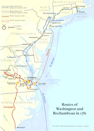
The Washington–Rochambeau Revolutionary Route is a 680-mile (1,090 km) series of roads used in 1781 by the Continental Army under the command of George Washington and the Expédition Particulière under the command of Jean-Baptiste de Rochambeau during their 14-week march from Newport, Rhode Island to Yorktown, Virginia. 4,000 French and 3,000 American soldiers began the march.

The Smithfield Road Historic District is a rural historic district in North Smithfield, Rhode Island, along Old Smithfield Road. It extends along Old Smithfield Road north from its junction with Sayles Hill Road, and is roughly bisected by Spring Brook. It includes eight historic houses or farmsteads, two 19th-century cemeteries, and a dam on Spring Brook just east of the road. The district encompasses a cross-section of the development of agricultural properties in North Smithfield over the 19th century, with properties dating from 1811 to 1932. The district covers 170 acres (69 ha), which includes lands currently and formerly in agricultural use.

Tiverton Four Corners Historic District encompasses the main village center of Tiverton, Rhode Island. The district extends along Main Road north and south from its junction with East Road and Puncatest Neck Road, or West Road. The 50-acre (20 ha) area consists of sixteen historic buildings, predominantly 18th and early 19th-century houses, as well as the 1868 Union Public Library, mill-related resources at the Mill Pond which was situated just southeast of the main intersection, and the A. P. White Store.

Arnold Mills Historic District is a historic district encompassing a modest 19th-century mill village in eastern Cumberland, Rhode Island. The district lies along the Nate Whipple Highway and Sneech Pond Road, south of the Arnold Mills Reservoir. Sneech Pond Road was formerly the major east-west highway through the area prior to the construction of the Nate Whipple Highway in the 1960s. The Arnold Mills village is in part bisected by Abbott Run, the stream which serves as the outlet of the reservoir; Sneech Pond Road crosses the run on an early 20th-century steel Pratt pony truss, now closed to vehicular traffic. The houses along this road generally date from the late 18th to mid-19th century, and mainly reflect Federal and Greek Revival styling. The most prominent structure in the district is the Arnold Mills United Methodist Church, located at the western end of the district on Nate Whipple Highway; it was built 1825-27 and remodeled in 1846.
Clayville Historic District is an 81-acre (33 ha) historic district in Foster and Scituate, Rhode Island. The district encompasses the heart of the village of Clayville, a small 19th-century mill village. It is centered on the junction of Plainfield Pike, Field Hill Road, and Victory Highway near the Clayville Mill pond, and is roughly bisected by the town line between Foster and Scituate. The mill pond is impounded by a c. 1847 dam, which powered mills whose ruins and waterways lie downstream. The village is mainly residential, with vernacular 19th-century construction predominating. Notable buildings include the Clayville Christian Union Church, built 1867–71 with Greek Revival styling, and the c. 1845 Clayville Schoolhouse.

The Lippitt Hill Historic District is a historic district in Cranston, Rhode Island along Hope Road between Laten Knight Road and Hope Road's junction with Burlingame Road and Lippitt Avenue. This area was settled by Moses Lippitt, who in 1735 built a Georgian farmhouse for his son Christopher. Christopher later (1805) built a Federal style house for his son William. These two farmhouses are the anchors of this rural district, which also includes a historical cemetery in which many generations of Lippitts are buried, and which features a unique heart-shaped planting of pine trees.
The Mount Vernon Tavern, also known as the Bank House Tavern, is an historic house in Foster, Rhode Island. It is located at 199 Plainfield Pike, about 3/10 of a mile east of its junction with Howard Hill Road. The main block of the house, a 2+1⁄2-story wood-frame structure with gable roof, was built c. 1760, and was originally attached to an even older structure which was demolished in the late 19th century. This main block, five bays wide with a central chimney, is attached to a 1+1⁄2-story gable-roofed ell to the west. The main entrance portico features unusually elaborate Federal styling for a rural location, and was probably added in 1814. The house has long been a landmark on the road, serving as a stagecoach stop on what was the main road between Providence and points in Connecticut.

The Hopkins Mill District is a historic district in Foster, Rhode Island. It encompasses a historic mill village that extends along Old Danielson Pike between its two junctions with Danielson Pike. The area has been the site of mills since the 18th century, and includes one of Foster's oldest houses, the c. 1720 Hopkins-Potter House at 21 Old Danielson Pike. Prominent public buildings in the district include the c. 1830 Curtis Hall at 18 Danielson Pike, which was long used as a tavern and social gathering place, and the 1869-71 Hopkins Falls Union Church.

The Wanskuck Historic District is a historic district in the city of Providence, Rhode Island encompassing a mill village with more than two hundred years of history. As early as the mid-18th century, mills stood on the West River in northern Providence, a development which continued with the rise of industrialization in the 19th century. The mill village of Wanskuck is organized around three thoroughfares: Branch Street, Veazie Street, and Woodward Road, and is roughly bounded on the east by Louisquisset Pike and to the northwest by the city line with North Providence. The West River runs through the district, with its banks lined by two late-19th-century mill complexes. The village area includes a variety of examples of mill worker housing, from duplexes to rowhouses, as well as two church complexes and a community hall built in 1884 by the Wanskuck Company.

The Hope Village Historic District is a historic rural mill settlement within Hope Village in Scituate, Rhode Island. Hope Village is located on a bend in the North Pawtuxet River in the southeastern corner of Scituate. Industrial activity has occurred in Hope Village since the mid-eighteenth century. Surviving industrial and residential buildings in the Historic District date back to the early 19th century. The village center sits at junction of Main Street and North Road. Hope Village radiates out from the center with houses on several smaller side streets in a compact configuration. Currently there is little commercial or industrial activity in Hope Village and none in the Historic District. The present stone mill building on the south side of Hope Village was built in 1844 by Brown & Ives of Providence, expanded in 1871 and modified in 1910. Approximately one quarter of the village's current housing stock was built as mill worker housing by various owners of Hope Mill.

Hopkinton City Historic District is a historic district encompassing the town center of Hopkinton, Rhode Island. The district is centered on the junction of Rhode Island Route 3 with Woodville Road, Clark Falls Road, Townhouse Road, and Old Rockville Road. It is a relatively modest town center, with twenty residences, two church buildings, the town hall, and post office. The most imposing house in the district is the Thurston-Wells House, a c. 1800 structure which was given a Victorian treatment in the mid-19th century; it stands opposite the 1836 Greek Revival First Baptist Church. The area was a major stop on the stagecoach route, and was eclipsed in the 20th century by the construction of Interstate 95, which passes nearby.
Lafayette Village is a historic district extending along Ten Rod Road in North Kingstown, Rhode Island. It encompasses a linear rural and industrial village, running from the Wickford Junction railroad crossing in the west to Angel Avenue in the east, and includes a number of residential properties on adjacent side streets. The centerpiece of the district is the Rodman Manufacturing Company complex, which operated here for a century beginning in the 1840s. The Robert Rodman Mansion, a Second Empire house with an elaborate porch, stands at 731 Ten Rod Road, and the Walter Rodman House, built in the 1870s, is even more elaborately decorated. Most of the residential stock in the district is mill-related housing built by the Rodmans for their workers.
The Isaac Bowen House is an historic house in Coventry, Rhode Island. The 2+1⁄2-story center-chimney wood-frame house, built c. 1750, stands on Maple Valley Road, near its junction with Rhode Island Route 102. The property, more than 3 acres (1.2 ha) extending to the road junction, is adjacent to the Audubon Society's George B. Parker Woodland Sanctuary, and is also owned by the society. The house was built by Isaac Bowen, a member of the locally prominent Bowen family, and is the only Bowen house to survive from that time. The house now serves as home to the Parker Sanctuary's caretaker.
The William Waterman House is a historic house in Coventry, Rhode Island. It is located on the west side of Rhode Island Route 102, a short way north of its junction with Bowen Hill Road. The 2+1⁄2-story wood-frame house was built, probably before 1793, by William Waterman, a descendant of one of Coventry's earliest European settlers. It is five bays wide, with a large central chimney. Its entry is the most elaborate part of the main facade, flanked by paired pilasters and sheltered by a barrel-vaulted portico with triangular pediment.
The Sterling Hill Historic District encompasses a well-preserved early 19th-century rural village center on western edge of the town of Sterling, Connecticut. Centered at the junction of Plainfield Pike and Sterling Hill Road, it consists of a cluster of 19th and early 19th-century houses, and a church. Unlike other period villages, it has largely been unaffected by later development. It was listed on the National Register of Historic Places in 1986.

March Route of Rochambeau's Army: Plainfield Pike is a 3.6 mile-long road segment in Plainfield and Sterling, Connecticut which forms a portion of the historic march route of Comte de Rochambeau's army in June 1781 on its way to Yorktown, Virginia, and again of the returning army in November 1782. It was listed on the National Register of Historic Places (NRHP) in 2003.

Hopkins Hollow Village is an historic district along Hopkins Hollow Road, Narrow Lane, and Perry Hill Road in Coventry, Rhode Island, United States, and West Greenwich, Rhode Island.

Anthony is a village along Route 117 within the town of Coventry, Rhode Island near the villages of Washington and Quidnick on the southwestern banks of the Pawtuxet River. The village comprises "Anthony, Arnold, Boston, Mapledale, Meeting, Taft, Washington and Laurel Avenue."


