
Central, commonly known as Central City, is a home rule municipality located in Gilpin and Clear Creek counties, Colorado, United States. Central City is the county seat and the most populous municipality of Gilpin County. The city population was 779, all in Gilpin County, at the 2020 United States census. The city is a historic mining settlement founded in 1859 during the Pike's Peak Gold Rush and came to be known as the "Richest Square Mile on Earth". Central City and the adjacent city of Black Hawk form the federally designated Central City/Black Hawk Historic District. The city is now a part of the Denver–Aurora–Lakewood, CO Metropolitan Statistical Area and the Front Range Urban Corridor.

Gilpin County is a county located in the U.S. state of Colorado, smallest in land area behind only the City and County of Broomfield. As of the 2020 census, the population was 5,808. The county seat is Central City. The county was formed in 1861, while Colorado was still a territory, and was named after Colonel William Gilpin, the first territorial governor.

City of Colorado Springs Municipal Airport, known as Colorado Springs Airport, is a city-owned public civil-military airport 6 miles (9.7 km) southeast of downtown Colorado Springs, in El Paso County, Colorado, United States. It is the second busiest commercial service airport in the state after Denver International Airport. Peterson Space Force Base, which is located on the north side of runway 13/31, is a tenant of the airport.

The Colorado State Capitol Building, located at 200 East Colfax Avenue in Denver, Colorado, United States, is the home of the Colorado General Assembly and the offices of the Governor of Colorado, Lieutenant Governor of Colorado, and the Colorado State Treasurer.

The National Register of Historic Places in the United States is a register including buildings, sites, structures, districts, and objects. The Register automatically includes all National Historic Landmarks as well as all historic areas administered by the U.S. National Park Service. Since its introduction in 1966, more than 90,000 separate listings have been added to the register.

There are more than 1,500 properties and historic districts in the U.S. State of Colorado listed on the National Register of Historic Places. They are distributed over 63 of Colorado's 64 counties; only the City and County of Broomfield currently has none.
Saco Rienk DeBoer was a Dutch landscape architect and city planner. He was born on September 7, 1883, in Ureterp, Opsterland, Friesland, Netherlands to architect Rienk Kornelius De Boer and avid gardener Antje Dictus Benedictus. He studied engineering and passed the Junior Engineer (surveyor) exam. He went on to study landscape architecture at The Royal Imperial School of Horticulture in Germany. He was diagnosed with tuberculosis, on the advice of doctors him to return home to Ureterp where he opened an office. His symptoms worsened in the summer of 1908, on doctor and family advice he emigrated to the United States in October 1908 be cured at the Dutch operated Bethesda Sanatarium in Maxwell, NM. In 1909 when Bethesda Sanitarium moved to Denver, he moved with it, planning the landscaping for the new building. He became the official Landscape Architect of Denver from 1910 to 1931. He also designed the planned community of Boulder City, Nevada. In 1919, he joined with another Dutchman, M. Walter Pesman, to form a partnership. Together their projects were many, among them the landscaping of both sides of Speer Boulevard in Denver, and two early and innovative Colorado subdivisions, Bonnie Brae in Denver and The Glens in Lakewood, both of which feature winding streets and multiple small "pocket parks."

City Park is an urban park and neighborhood in Denver, Colorado. The park is 330 acres (1.3 km2) and is located in east-central Denver. The park contains the Denver Zoo, the Denver Museum of Nature and Science, Ferril and Duck Lakes, and a boathouse. City Park is also the name of the neighborhood that contains the park, though the park is the vast majority of the neighborhood. To the immediate north of the park is the City Park Golf Course. City Park is the largest park in Denver.

There are 309 properties and districts listed on the National Register of Historic Places in the City and County of Denver, the capital of the U.S. State of Colorado.
This National Park Service list is complete through NPS recent listings posted August 4, 2023.

Jules Jacques Benois Benedict was one of the most prominent architects in Colorado history, whose works include a number of well-known landmarks and buildings listed on the National Register of Historic Places.

Cheesman Park is an urban park and neighborhood located in the City and County of Denver, Colorado, United States.
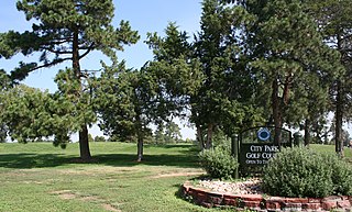
City Park Golf is a historic 18-hole regulation golf course located north of Denver's City Park. The area is bounded by E. Twenty-sixth Ave., Colorado Blvd., E. Twenty-third Ave., and York St.

South Marion Street Parkway is a historic parkway in Denver, Colorado. It was listed on the National Register of Historic Places in 1986 as part of a set of listings commemorating Denver's Park and Parkway System.

This is a list of the National Register of Historic Places listings in Northeast Denver, Colorado.
This is a list of the National Register of Historic Places listings in Downtown Denver, Colorado.

Bear Creek Canyon Drive, a linear district, includes two miles of scenic road, which is now part of State Highway 74. The drive is between the town of Morrison and the town of Idledale. The scenic drive connects to the west border of the Red Rocks Mountain Park District. The Denver Mountain Parks owns a 200 feet (61 m) strip of canyon on both sides of Bear Creek. The park was purchased in 1928, and the road ran along the stream and was subject to flooding. During the 1930s and early 1940s the Civilian Conservation Corp (CCC) moved parts of the road away from the stream and raised it above the flood plain. The road is maintained by the Colorado State Highway Department. It was constructed and first maintained by the State Department of Highways, Jefferson County, and the City of Denver Mountain Parks. The first section of the road had been a narrow stagecoach route and needed to be graded not to exceed grades more than six percent. Road improve began in 1914, with the construction of a road from Denver to Morrison. The entire route was completed by 1921.

State Highway 74 (SH 74) is a state highway in the U.S. state of Colorado. Running 18 miles (29 km) from Interstate 70 (I-70) in El Rancho to SH 8 in Morrison, the highway roughly follows a hook-shaped path running northwest–southeast. The section of the route north of the town of Evergreen is known as Evergreen Parkway and is a segment with a four- to six-lane roadway, with the section east of Evergreen mostly two lanes. The other section is known as the Bear Creek Canyon Scenic Mountain Drive, or just Bear Creek Road, and primarily parallels Bear Creek, passing through the towns of Kittredge and Idledale. The route, which is on the outskirts of Denver, passes through several of the city's mountain parks, including Bergen, Dedisse and Red Rocks parks.

Speer Boulevard, in Denver, Colorado, is a historic parkway. It runs from Irving St. in the West Highland neighborhood to Downing St. in the Country Club neighborhood, was built in 1906, and was listed on the National Register of Historic Places in 1986.

East Sixth Avenue Parkway is a parkway, part of the Denver Park and Parkway System, which was built in 1909. It was listed on the National Register of Historic Places in 1986.

Monaco Street Parkway, in Denver, Colorado, is a parkway, part of the Denver Park and Parkway System, which was designed by architect S.R. DeBoer and was built in 1907. It was listed on the National Register of Historic Places in 1986.


