River Lyde (Hampshire)

Last updated

Lyde
Lyde River - geograph.org.uk - 146721.jpg
The Lyde River, looking downstream from the A30 Bridge at Water End
Location
Country England
Counties Hampshire
Physical characteristics
Source 
  location Mapledurwell
  coordinates 51°15′21″N1°02′32″W / 51.2559°N 1.0421°W / 51.2559; -1.0421
Mouth River Loddon
  location
Sherfield on Loddon
  coordinates
51°18′46″N1°00′31″W / 51.3129°N 1.0087°W / 51.3129; -1.0087 Coordinates: 51°18′46″N1°00′31″W / 51.3129°N 1.0087°W / 51.3129; -1.0087
Length6.2 mi (10.0 km)
Lyde River
BSicon uexCONTg.svg
River Loddon
BSicon uexABZgl.svg
BSicon uexABZq+r.svg
BSicon uexSTR+r.svg
Lyde River
BSicon uexSTR.svg
BSicon uexSTR.svg
BSicon uxMILL.svg
Hartley Mill
BSicon uexSTR.svg
BSicon uexSTRl.svg
BSicon uxWEIRl.svg
BSicon uexCONTfaq.svg
BSicon uexSTRq.svg
BSicon uexSTR+l.svg
BSicon uexSTRr.svg
BSicon uexSTRq.svg
BSicon uexSTRr.svg
River Loddon
BSicon uexSKRZ-Yu.svg
Newnham Lane Bridge
BSicon uexSTR+l.svg
BSicon uexABZgr.svg
BSicon uexSTR.svg
BSicon uxMILL.svg
Lyde Mill
BSicon uexSTRl.svg
BSicon uxWEIRl.svg
BSicon CONTgq.svg
BSicon uxmKRZu.svg
BSicon CONTfq.svg
South West Main Line
BSicon uexSKRZ-Au.svg
A30 Water End bridge
BSicon uexSTR+l.svg
BSicon uexABZgr.svg
BSicon uexSTR.svg
BSicon uxMILL.svg
Andwell Mill
BSicon uexSTRl.svg
BSicon uxWEIRl.svg
BSicon uexSTR+l.svg
BSicon uexABZlr.svg
BSicon uexSTR+r.svg
BSicon uexABZgl.svg
BSicon uexKHSTeq.svg
BSicon uexSKRZ-Bu.svg
UK-Motorway-icon.svg M3 bridge
BSicon uexSKRZ-Yu.svg
Greywell Road
BSicon uexSKRZ-Bu.svg
BSicon uexSTR.svg
UK-Motorway-icon.svg M3 bridge
BSicon gCONTgq.svg
BSicon uxgKRZu.svg
BSicon gSTR+r.svg
BSicon uexSTR.svg
BSicon uexBHF.svg
BSicon gSTR.svg
BSicon uexBHF.svg
Watercress beds
BSicon uexSTR.svg
BSicon gSTRl.svg
BSicon uxgKRZu.svg
BSicon gCONTfq.svg
Basingstoke Canal (derelict)
BSicon uexSTR+l.svg
BSicon uexABZglr.svg
BSicon uexSTR+r.svg
BSicon uexKHSTe.svg
source at Mapledurwell
BSicon uexKHSTe.svg
BSicon uexKHSTe.svg
BSicon uexKHSTe.svg
sources at Huish

The River Lyde or Lyde River is a small river in the English county of Hampshire. It rises near Mapledurwell, where the water is used in watercress beds before entering the main channel. It flows in a generally northerly direction, and used to supply power to watermills along its route. Near Sherfield on Loddon it joins the River Loddon, which is a tributary of the River Thames.

Contents

Route

The Lyde River rises as a series of springs on the chalk aquifer to the west of Mapledurwell. Almost immediately, it runs through a number of watercress beds, which are part of Huish Farm. The main house was built in 1909 for the Westray family, in Domestic Revival style, with a red brick ground floor, timber framing on the first floor, and an attic above that. Most of the internal features are in original condition. It is a grade II listed structure, [1] as are the associated barn and granary. To the north of the farm, the river is crossed by the M3 motorway, but the bridge marks the location where the Basingstoke Canal once crossed, on its way to Basingstoke. The canal was never a commercial success, and the last boats to use this section did so in 1914. The section further east continued to be used until 1949, but when restoration began in the 1970s, progress was hampered by the partial collapse of the Greywall Tunnel, and the fact that the largest population of bats in Europe use it for hibernation in the winter. The construction of the M3 motorway sealed the fate of the western section. [2]

Beyond the motorway, there are a network of drains and springs, which swell the flow, before it turns to the east to reach Priory Farm at Andwell. This was the site of St Mary's Priory from around 1130 until 1391, when it was dissolved. It was an alien priory, under the control of the Tironensian Order in France. Parts of the priory have been incorporated into Priory Farmhouse, a grade I listed building, which was altered and extended in the 17th and 19th centuries. [3] The adjacent barn, stable and cartshed are also listed structures. The river passes around the southern edge of the site, and is joined by another stream, which rises by the grade II* listed church of St Mary, Mapledurwell, which dates from the 13th and 15th centuries, with 19th century restorations. [4] The spring is at 242 feet (74 m) above Ordnance datum, [5] from which the stream weaves its way northwards, on both sides of Frog Lane, and there are more watercress beds, either side of the former course of the canal, before it passes under Greywell Road and the motorway to reach the main waterway. [6]

The river then resumes its northward course, and there are a number of sluices and weirs, which were part of Andwell Mill. The mill building has survived, a massive structure dating from the 17th century, but heavily modernised around 1900. [7] Andwell Mill Trout Farm now operated a little further downstream. It produces smoked trout, some from locally-grown fish and some from imported fish. The business began in 1979, and in 1993 won a planning appeal to allow them to extend, which had been declined because so much of the fish was imported. However, the amount of locally sourced fish that could be produced was restricted by the volume of water that their abstraction licence allowed them to take from the river. [8] The name Andwell is derived from two words both meaning "well". "An" is from the Celtic language and "well" from Saxon. [5] At Water End the river is crossed by the A30 road, passes a large mobile home park, and then is crossed by the South West Main Line railway. Just before a bridge carrying Newnham Lane is the site of Lyde Mill. The mill house dates from the 17th and late 18th centuries, with some modern extensions. [9] The river then meanders across open countryside, passing very close to the Loddon, and then moving away to reach the early 19th century Hartley Mill. The mill itself had two storeys and an attic, with an attached two-storey mill house. Both parts have been adapted to form a single house, and although the water wheel has gone, a number of iron wheels from the original machinery have been retained as decoration. [10] Shortly after the mill, the river joins the Loddon. [6]

Milling

There is clear evidence of three water mills on the river, all of which were corn mills in 1873, [11] but during the 17th century there were five operational mills powered by the Lyde. [12] The present Andwell Mill building dates from the 17th century, it is Grade II listed. [7] Lyde Mill, another Grade II listed building, also dates from the 17th century, [9] although there is evidence for milling at Lyde from 1086. [12] It is located in the parish of Newnham, which was part of the parish of Mapledurwell until 1178, and so did not appear in the Domesday Book. Mapledurwell was noted as having two mills at that time, one of which was probably at the site of Lyde Mill. [13] Newnham has had two corn mills and a paper mill at various points in its history, as well as a foundry and two brickworks. It is unclear where the two mills were, as the eastern boundary of Newnham was once on the River Whitewater, which powered Hook corn mill, and so the two may have been one on each river. [14] The village church was served by monks from West Sherborne Priory, and this was facilitated by Henry de Port, who gave money to the priory. A charter that he made in 1130 in this context mentions tithes from two mills in the parish, [15] while in 1766, David Crimble of Lyde Mill was responsible for the upkeep of two panels of the churchyard fence. At the same time, Edward Chamberlain of Paper Mill was responsible for a further four panels, [16] but this was the paper mill on the Whitewater at Wolson Bridge, [17] now the Crooked Billet Bridge on the A30 road. Hartley Mill building dates from the 19th century and is a Grade II listed building. [10]

Ecology

The Lyde is a classic chalk stream, with clear water and an abundance of aquatic plants, including water-crowfoot, water starwort and water moss. In 2009 the water quality was rated class A, in the system used at the time, and the aquifer from which the water came was protected against further abstraction of groundwater. The river is populated by a number of fish species that form part of the Biodiversity action plan for the area, including wild brown trout, European bullhead and brook lamprey. It used to have a good population of white-clawed crayfish but this native breed has now been largely replaced by the invasive North American signal crayfish. [18]

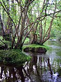
In 2009, the Wild Trout Trust carried out a survey of the 0.6-mile (1 km) section from the railway bridge downstream to near Lyde Mill, on behalf of the riparian owners who live at Manor Farm. They found that the channel near the mill appears to have been diverted, and the banks raised to increase the head of water for the mill. When this occurred is not known, since there has been a mill in this vicinity since 1086. The river has also been affected by post-war efforts to increase agricultural output, which resulted in drainage works and the dredging of the channel. This has resulted in the channel being larger than would be expected for the size of river, and of uniform shape, without the changes in water velocity that a more natural course normally creates. This results in the water moving slowly, with sediments smothering the bed and marginal plants such as bur reed and reed sweet-grass growing right across the channel. [12]

For trout to thrive, they need a variety of habitats, and there was only one 22-yard (20 m) section near the railway that was suitable for spawning. However, there were long sections above the railway where there were shallow riffles, with the water flowing over loose gravel and low scrub covering shallow margins, which is ideal for spawning and as habitat for juvenile trout. [19] The report concluded that the river could be significantly improved for trout if the hatches at Lyde Mill could be altered to lower the surface water level a little, and thus increase the water velocity. Creating areas of dappled shade by some felling of trees, particularly where they form dense cover of the river would also be beneficial, and the felled wood could be used as large woody debris, to narrow the channel and scour sediments from the bed. Large woody debris has been shown to significantly increase the range of habitats within a river. [20]

Water Quality

The Environment Agency measure water quality of the river systems in England. Each is given an overall ecological status, which may be one of five levels: high, good, moderate, poor and bad. There are several components that are used to determine this, including biological status, which looks at the quantity and varieties of invertebrates, angiosperms and fish, and chemical status, which compares the concentrations of various chemicals against known safe concentrations. Chemical status is rated good or fail. [21]

The water quality of the Lyde River was as follows in 2019.

SectionEcological
Status
Chemical
Status
Overall
Status
LengthCatchment
Lyde [22] Poor Fail Poor 6.2 miles (10.0 km)12.27 square miles (31.8 km2)

Reasons for the water quality being less than good are all to do with physical modification of the channel, particularly for land drainage and milling, which prevents free movement of fish along the river. The water quality was Good from 2009 to 2013, as the biological elements measured populations of invertebrates, but not fish. It has been poor since 2014, as fish migration was included in the biological elements from that date, and the barriers to movement of fish are severe.

Bibliography

Related Research Articles

River Blackwater (River Loddon) Tributary of the River Loddon in England

The River Blackwater is a tributary of the Loddon in England and sub-tributary of the Thames. It rises at two springs in Rowhill Nature Reserve between Aldershot, Hampshire and Farnham, Surrey. It curves a course north then west to join the Loddon in Swallowfield civil parish, central Berkshire. Part of the river splits Hampshire from Surrey; a smaller part does so as to Hampshire and Berkshire.

River Ryton River in Nottinghamshire, England

The River Ryton is a tributary of the River Idle. It rises close to the Chesterfield Canal near Kiveton Park, and is joined by a series of tributaries near Lindrick Common in the Metropolitan Borough of Rotherham, South Yorkshire, England. Most of its course is in Nottinghamshire, flowing through the town of Worksop. It meanders northwards to join the River Idle near the town of Bawtry on the South Yorkshire-Nottinghamshire border.

River Loddon River in southern England

The River Loddon is a tributary of the River Thames in southern England. It rises at Basingstoke in Hampshire and flows northwards for 28 miles (45 km) to meet the Thames at Wargrave in Berkshire. Together, the Loddon and its tributaries drain an area of 400 square miles (1,036 km2).

River Allen, Dorset River in Dorset, England

The River Allen is a river in the county of Dorset in South West England. It flows for 14 miles (23 km) and has its confluence with the River Stour in Wimborne Minster. It has two main tributaries, the Gussage Stream and the Crichel Stream.

Foudry Brook River in Hampshire and Berkshire, England

Foudry Brook is a small stream in southern England. It rises from a number of springs near the Hampshire village of Baughurst, and flows to the east and then the north, to join the River Kennet to the south of Reading. The upper section is called Silchester Brook, and beyond that, Bishop's Wood Stream. The underlying geology is chalk, covered by a layer of clay, and so it has the characteristics of a clay stream, experiencing rapid increases in level after heavy rain due to run-off from the surrounding land. It passes a number of listed buildings and scheduled monuments, including the site of the Roman town of Calleva Atrebatum or Silchester.

River Chess River in Buckinghamshire and Hertfordshire, England

The River Chess is a chalk stream that rises near Chesham in the Chiltern Hills, and flows for 11 miles (18 km) through Buckinghamshire and Hertfordshire to its confluence with the River Colne in Rickmansworth. The Chess, along with the Colne and Gade, gives rise to the name of the district of Three Rivers,.

Chalk stream Rivers that rise from springs in landscapes with chalk bedrock

Chalk streams are rivers that rise from springs in landscapes with chalk bedrock. Since chalk is permeable, water percolates easily through the ground to the water table and chalk streams therefore receive little surface runoff. As a result, the water in the streams contains little organic matter and sediment and is generally very clear. The beds of the rivers are generally composed of clean, compacted gravel and flints, which are good spawning areas for Salmonidae fish species.

River Alre River in Hampshire, England

The River Alre is a tributary of the River Itchen in Hampshire in the south of England. It rises in Bishop's Sutton and flows west for 6 km (3.7 mi) to meet the Itchen below New Alresford.

Andwell Human settlement in England

Andwell is a village in the Basingstoke and Deane district of Hampshire, England. Its former range was divided by the M3 motorway; it is also bounded to the north by the A30 road. Winchester College has owned land in the village since the 1390s.

River Whitewater River in Hampshire, England

The River Whitewater rises at springs near Bidden Grange Farm between Upton Grey and Greywell in Hampshire, England. It flows northeast and is a tributary of the River Blackwater near Swallowfield. Its headwaters flow over chalk and there is little pollution making the River Whitewater rich in wildlife. It was noted on Jansson's map of Hampshire of 1646.

Headbourne Worthy Human settlement in England

Headbourne Worthy is a village and former manor within the City of Winchester district of Hampshire, England. The parish also includes the former manor of Worthy Pauncefoot.

Warnford Human settlement in England

Warnford is a village and civil parish in the City of Winchester district of Hampshire, England. The parish covers 1283 hectares. The population in 2019 was estimated at 220.

Andwell Priory is an alien priory of Benedictine monks in Andwell, Hampshire, England.

Mapledurwell Human settlement in England

Mapledurwell is a village in Hampshire, England, that is located south east of Basingstoke. The name Mapledurwell means 'maple tree spring.'

Up Nately Human settlement in England

Up Nately is a small village in Hampshire, England, located to the south east of Basingstoke. Its nearest railway station is in Hook, three miles to the east of the village. The Basingstoke Canal runs through the village from the former Penny Bridge in the west, under Brick Kiln Bridge, Slades Bridge and Eastrop Bridge, and, to the east of the village, through the collapsed Greywell Tunnel.

Pamber Priory

Pamber Priory is a Church of England parish church and former priory, then known as West Sherborne Priory or Monk Sherborne Priory, at Monk Sherborne in the English county of Hampshire.

River Hart Tributary of the River Whitewater in north Hampshire, England

The River Hart is a tributary of the River Whitewater in north Hampshire, England. It rises at Ashley Head spring in Crondall and flows north to meet the Whitewater at Bramshill.

Oldcotes Dyke

Oldcotes Dyke is the name of the final section of a river system that drains parts of north Nottinghamshire and the Metropolitan Borough of Rotherham in South Yorkshire, England. Historically, it has supported milling, with seven water mills drawing their power from its water, and ran through the grounds of the Cistercian Roche Abbey. It is a tributary of the River Ryton.

Twyford Brook River in Berkshire, England

Twyford Brook is a small English river in the county of Berkshire. It drains a rural area to the east of Twyford, starting at the foot of the M4 motorway embankment, and is a tributary of the River Loddon. It was once part of a larger river system, draining the area now occupied by the new town of Bracknell. Because of issues with flooding, a new channel was cut to carry the water to the River Thames at Bray. The new channel and the river upstream from there is now known as The Cut, and the old channel became known as Twyford Brook.

Bow Brook, Hampshire River in Hampshire, England

Bow Brook is a small river in the English county of Hampshire, which is a tributary of the River Loddon. Contributary streams rise near Ramsdell and Sherborne St John, and after flowing through rural countryside, it joins the Loddon near Sherfield on Loddon. Historically is has powered at least two watermills.

References

  1. Historic England. "Huish House (1245367)". National Heritage List for England . Retrieved 30 June 2020.
  2. Cumberlidge 2009, pp. 71-72.
  3. Historic England. "Priory Farmhouse (1339548)". National Heritage List for England . Retrieved 30 June 2020.
  4. Historic England. "Church of St Mary (1092979)". National Heritage List for England . Retrieved 30 June 2020.
  5. 1 2 Shore 1890, p. 48.
  6. 1 2 Ordnance Survey, 1:2500 map
  7. 1 2 Historic England (17 October 1984). "Andwell Mill (Grade II) (1092939)". National Heritage List for England . Retrieved 30 June 2020.
  8. Rosson 1993, p. 2.
  9. 1 2 Historic England (17 October 1984). "Lyde Mill House (Grade II) (1092929)". National Heritage List for England . Retrieved 30 June 2020.
  10. 1 2 Historic England (17 October 1984). "Mill House (Grade II) (1178759)". National Heritage List for England . Retrieved 30 June 2020.
  11. Ordnance Survey, 1:2500 map, 1872-1873
  12. 1 2 3 Thomas 2009, p. 3.
  13. Bell 2004, p. 2.
  14. "Newnham Introduction" (PDF). Victoria County History - draft new edition. August 2019. p. 3. Archived (PDF) from the original on 2 July 2020.
  15. Bell 2004, pp. 4,9.
  16. Bell 2004, p. 14.
  17. Shorter 1953, p. 9.
  18. Thomas 2009, pp. 2-3.
  19. Thomas 2009, pp. 4-5.
  20. Thomas 2009, p. 7.
  21. "Glossary (see Biological quality element; Chemical status; and Ecological status)". Catchment Data Explorer. Environment Agency. 17 February 2016. UKOpenGovernmentLicence.svg Text was copied from this source, which is available under an Open Government Licence v3.0. © Crown copyright.
  22. "Lyde". Catchment Data Explorer. Environment Agency.

Commons-logo.svg Media related to River Lyde, Hampshire at Wikimedia Commons