Related Research Articles
Haddam is a town in Middlesex County, Connecticut, United States. The population was 8,346 at the 2010 census. The town was also home to the now decommissioned Connecticut Yankee nuclear reactor.

Keene is a town in central Essex County, New York, United States. It includes the hamlets of Keene, Keene Valley, and St. Huberts, with a total population of 1,105 as of the 2010 census.
This is a list of properties and districts in Mississippi that are listed on the National Register of Historic Places. There are more than 1,400 sites distributed among all of Mississippi's 82 counties.
The South Hadley Canal was a canal along the Connecticut River in South Hadley, Massachusetts. It was the earliest navigable canal in the United States, with operation commencing in 1795. It has been listed on the National Register of Historic Places as the South Hadley Canal Historic District.
The Eightmile River has its source along a small drainage into several small swamps in an undeveloped region about three miles east of Bashan in the town of East Haddam, Connecticut. This source is fairly centered between Ackley Road, Hall Kilbourne Road, Usher Swamp Road, and Miles Standish Road. The Eightmile River runs for 13.4 miles (21.6 km) to Hamburg Cove near Hamburg, Connecticut.

Roaring Creek is a tributary of the Susquehanna River in Columbia County and Montour County, in Pennsylvania, in the United States. It is slightly more than 20 miles (32 km) long and flows through Roaring Creek Township, Locust Township, Catawissa Township, Cleveland Township, and Franklin Township in Columbia County and Mayberry Township in Montour County. The watershed of the creek has an area of 87.3 square miles (226 km2). It has three named tributaries: South Branch Roaring Creek, Lick Run, and Mill Creek. The creek is not considered to be impaired and is not affected by coal mining. However, its watershed has been impacted by human land use. Claystones, conglomerates, sandstones, siltstones, and shales all occur within the watershed. The creek flows through a gorge in its lower reaches, along the border between Columbia County and Montour County.

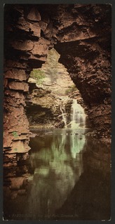
Devil's Hopyard State Park is a public recreation area located at the Eightmile River's Chapman Falls in the town of East Haddam, Connecticut. The 1,000-acre (400 ha) state park includes facilities for hiking, fishing, bicycling, picnicking, and camping. It is managed by the Connecticut Department of Energy and Environmental Protection.

The Middle Haddam Historic District is a historic district in the town of East Hampton, Connecticut. It encompasses the village center of Middle Haddam, a riverfront community founded in the 17th century on the east bank of the Connecticut River. It was an important port on the river between about 1730 and 1880. Its layout and architecture are reflective of this history, and by the geographic constraints of the local terrain. The district was listed on the National Register of Historic Places in 1984.

The South Glastonbury Historic District is a historic district in Glastonbury, Connecticut. It encompasses the historic village center of South Glastonbury, which was first settled in the 17th century. The district was listed on the National Register of Historic Places in 1984, and enlarged in 2009 to include properties further along Main Street as far as Chestnut Hill Road. Locals refer to it as Nayaug.

There are three bridges carrying Hopyard Road over several brooks within Devil's Hopyard State Park in the U.S. state of Connecticut. The main route of SSR 434 follows the Eightmile River and the bridges cross over its minor tributaries. All three bridges are listed on the National Register of Historic Places. The three bridges are essentially identical masonry arch bridges, 38 feet (12 m) long, with a roadbed 22 feet (6.7 m) wide, and were built using Depression-era federal jobs money. They are good examples of vernacular rustic park architecture.

The Hadlyme Ferry Historic District encompasses a collection of historic buildings related to the Chester–Hadlyme Ferry in the Hadlyme village of Lyme, Connecticut. It is located at the eastern end of the ferry route across the Connecticut River, where ferries have been documented to run since 1769. The district includes six houses dating to the late 18th or early 19th century, as well as the site of the ferry slip. It was listed on the National Register of Historic Places in 1994.

Saville Dam is an earthen embankment dam with masonry work on the eastern branch of the Farmington River in southwestern Barkhamsted, Connecticut. The dam is 135 ft. tall and 1,950 ft. long and has an uncontrolled spillway on its western portion. It creates the Barkhamsted Reservoir which has a volume of 36.8 billion US gallons (139,000,000 m3) and is the primary water source for Hartford, Connecticut.
The Pachaug River is a 16.0-mile-long (25.7 km) river arising from the Pachaug State Forest at the Connecticut - Rhode Island border and draining into the Quinebaug River. It is crossed by the Ashland Mill Bridge in Griswold, Connecticut, a bridge which is listed on the U.S. National Register of Historic Places.
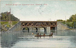
The Rippowam River is a river in Fairfield County, Connecticut, United States. It drains a watershed area of 37.5 square miles (97 km2) and flows for 17 miles (27 km) from Ridgefield to Long Island Sound, which it enters in Stamford's harbor.

The Valley Falls Cotton Mill Site is the site of a historic mill at Valley Falls Park in Vernon, Connecticut. Mills were operated on the site from colonial times until 1877, when the last mill burned. The site was listed on the National Register of Historic Places in 1997.
Roaring Brook is a tributary of the Lackawanna River in Lackawanna County, Pennsylvania, in the United States. It is approximately 21 miles (34 km) long and flows through Covington Township, Madison Township, Moscow, Roaring Brook Township, Elmhurst Township, Dunmore, and Scranton. The watershed of the stream has an area of 56.3 square miles (146 km2). Its named tributaries include Little Roaring Brook, Rock Bottom Creek, White Oak Run, Van Brunt Creek, Bear Brook, and East Branch Roaring Brook. It has a high level of water quality for much of its length. However, it is affected by abandoned mining land, stormwater, and other impacts in its lower reaches. Reservoirs in the watershed include the Hollister Reservoir, the Elmhurst Reservoir, and others. The stream also flows through the Nay Aug Gorge and passes over the Nay Aug Falls, which are on the National Register of Geologic Landmarks. It flows through a concrete channel in its lower reaches. The topography of the watershed contains rolling hills in its upper reaches and the mountainous land of the Moosic Mountains in its lower reaches.

The Selah Barnes House is a historic house at 282 Prospect Street Southington, Connecticut. Built about 1778 for a local merchant, it is a good local example of vernacular Georgian architecture. It was listed on the National Register of Historic Places in 1989.
The Hamburg Cove Site is a prehistoric archaeological site in Lyme, Connecticut. The site is believed to constitute a significant Native American habitation site, located near the mouth of the Eight Mile River at Hamburg Cove. Probably occupied between the Early and Late Woodland Periods, finds at the site include large numbers of deer bones, suggestive of extended occupation. Other features of the site include fireplace hearths, post moulds, and the remains of small mammals and turtles.

The Mill Brook Bridge is a historic stone arch bridge, located just north of Lower Blissville Road in Lisbon, Connecticut. With a plausibly estimated construction date of the 1790s, it is probably the oldest surviving stone arch bridge in the state. It was listed on the National Register of Historic Places in 1997. Since then, it has deteriorated and is partially collapsed.
References
- 1 2 "National Register Information System". National Register of Historic Places . National Park Service. March 13, 2009.
- 1 2 "Appendix 13: Assessment of the Eight Mile River's Archaeological Resources" (PDF). Eightmile River Watershed Management Plan. Eightmile River Wild and Scenic Coordinating Committee. 2005.
- ↑ "Chronology of the Prehistoric Periods of Southern New England". Archived from the original on 2013-01-05.