Rockingham, New Jersey

Last updated
Rockingham, New Jersey
Unincorporated community

Rockingham House.JPG

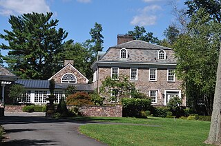
The historic Rockingham House, originally built in Rockingham.
Location map of Somerset County, New Jersey.svg
Red pog.svg
Rockingham, New Jersey
Location of Rockingham in Somerset County Inset: Location of county within the state of New Jersey
USA New Jersey location map.svg
Red pog.svg
Rockingham, New Jersey
Rockingham, New Jersey (New Jersey)
Usa edcp location map.svg
Red pog.svg
Rockingham, New Jersey
Rockingham, New Jersey (the US)
Coordinates: 40°23′52″N74°37′09″W / 40.39778°N 74.61917°W / 40.39778; -74.61917 Coordinates: 40°23′52″N74°37′09″W / 40.39778°N 74.61917°W / 40.39778; -74.61917
Country Flag of the United States.svg  United States
State Flag of New Jersey.svg  New Jersey
County Somerset
Township Franklin
Elevation [1] 213 ft (65 m)
GNIS feature ID 879761 [1]

Rockingham is an unincorporated community located within Franklin Township in Somerset County, New Jersey, United States. [2] The historic Rockingham House was built in Rockingham but has been moved several times.

Franklin Township, Somerset County, New Jersey Township in New Jersey

Franklin Township is a township in Somerset County, New Jersey, United States. As of the 2010 United States Census, the township's population was 62,300, reflecting an increase of 11,397 (+22.4%) from the 50,903 counted in the 2000 Census, which had in turn increased by 8,123 (+19.0%) from the 42,780 counted in the 1990 Census.

Somerset County, New Jersey county in New Jersey

Somerset County is a county located in the U.S. state of New Jersey. As of the 2017 Census estimate, the county's population was 335,432, a 3.7% increase from the 2010 United States Census, making it the 13th-most populous of the state's 21 counties. Somerset County is part of the New York Metropolitan Area. Its county seat is Somerville. The most populous place was Franklin Township, with 62,300 residents at the time of the 2010 Census, while Hillsborough Township, covered 55.00 square miles (142.4 km2), the largest total area of any municipality.

New Jersey State of the United States of America

New Jersey is a state in the Mid-Atlantic region of the Northeastern United States. It is a peninsula, bordered on the north and east by the state of New York, particularly along the extent of the length of New York City on its western edge; on the east, southeast, and south by the Atlantic Ocean; on the west by the Delaware River and Pennsylvania; and on the southwest by the Delaware Bay and Delaware. New Jersey is the fourth-smallest state by area but the 11th-most populous, with 9 million residents as of 2017, and the most densely populated of the 50 U.S. states; its biggest city is Newark. New Jersey lies completely within the combined statistical areas of New York City and Philadelphia and was the second-wealthiest U.S. state by median household income as of 2017.

Related Research Articles

Lewisville, New Jersey Unincorporated community in New Jersey, United States

Lewisville is an unincorporated community located within Lawrence Township in Mercer County, New Jersey, United States. The settlement is located along Lewisville Road near its intersection with Franklin Corner Road. A portion of The Lawrenceville School campus is within Lewisville as are residences and small office buildings.

Emleys Hill, New Jersey Unincorporated community in New Jersey, United States

Emleys Hill is an unincorporated community located within Upper Freehold Township in Monmouth County, New Jersey, United States. The settlement is located at the intersection of Emleys Hill Road and Burlington Path Road.

Alvater Corner, New Jersey Unincorporated community in New Jersey, United States

Alvater Corner is an unincorporated community located within Franklin Township in Hunterdon County, New Jersey, United States.

Lansdowne, New Jersey Unincorporated community in New Jersey, United States

Lansdowne is an unincorporated community located within Franklin Township in Hunterdon County, New Jersey, United States.

Clearbrook, New Jersey Unincorporated community in New Jersey, United States

Clearbrook is an unincorporated community located within Monroe Township in Middlesex County, New Jersey, United States.

Little Rocky Hill, New Jersey Unincorporated community in New Jersey, United States

Little Rocky Hill is an unincorporated community located within South Brunswick Township in Middlesex County and Franklin Township, Somerset County, New Jersey, United States. The community is located atop a small hill east of the borough of Rocky Hill. The Middlesex–Somerset county line runs through the community along Old Road though elsewhere it follows Route 27. Carters Brook runs through the area flowing south.

Riverview Manor, New Jersey Unincorporated community in New Jersey, United States

Riverview Manor is an unincorporated community located within Piscataway Township in Middlesex County, New Jersey, United States.

Sand Hills, Edison and Woodbridge, New Jersey Unincorporated community in New Jersey, United States

Sand Hills is an unincorporated community located along the border of Edison and Woodbridge townships in Middlesex County, New Jersey, United States.

Sayerwood South, New Jersey Unincorporated community in New Jersey, United States

Sayerwood South or Sayrewood South is an unincorporated community located within Old Bridge Township in Middlesex County, New Jersey, United States.

Shore Road Estates, New Jersey Unincorporated community in New Jersey, United States

Shore Road Estates is an unincorporated community located within Monroe Township in Middlesex County, New Jersey, United States.

Shore View, New Jersey Unincorporated community in New Jersey, United States

Shore View is an unincorporated community located within Woodbridge Township in Middlesex County, New Jersey, United States.

South Brunswick Terrace, New Jersey Unincorporated community in New Jersey, United States

South Brunswick Terrace is an unincorporated community located within South Brunswick Township in Middlesex County, New Jersey, United States.

South Old Bridge, New Jersey Unincorporated community in New Jersey, United States

South Old Bridge is an unincorporated community located within Old Bridge Township in Middlesex County, New Jersey, United States. The community consists of homes and businesses between New Jersey Route 18 and County Route 516 in the western portion of the township. The reason for the odd directional naming is because it is located south of the settlement of Old Bridge while the name of the township of the time was Madison Township.

Cooks Mills, New Jersey Unincorporated community in New Jersey, United States

Cooks Mills is an unincorporated community located within Colts Neck Township in Monmouth County, New Jersey, United States. Located on the eastern border of the township near Tinton Falls, it is situated in a rural area of the township surrounded by horse farms and large single-family houses.

Henningers Mills, New Jersey Unincorporated community in New Jersey, United States

Henningers Mills or Henningers Mill is an unincorporated community located along the border of Aberdeen and Marlboro townships in Monmouth County, New Jersey, United States.

Mount Pleasant, Monmouth County, New Jersey Unincorporated community in New Jersey, United States

Mount Pleasant is an unincorporated community located within Marlboro Township in Monmouth County, New Jersey, United States. It is named for a hill of the same name, one of the highest points in Marlboro Township. The settlement is located at the intersection of Reids Hill Road and Beacon Hill Road.

North Centerville, New Jersey Unincorporated community in New Jersey, United States

North Centerville is an unincorporated community located within Hazlet Township in Monmouth County, New Jersey, United States. Like most of Hazlet, North Centerville is largely suburban. The settlement is located at the intersection of Middle Road and Union Avenue in the center of the township.

Scotts Corner, New Jersey Unincorporated community in New Jersey, United States

Scotts Corner or Scotts Corners is an unincorporated community located within Plainsboro Township in Middlesex County, New Jersey, United States. The corner itself is located at the intersection of Scotts Corner Road and Dey Road in the eastern portion of the township. The area contains residential neighborhoods on all four quadrants of the intersection; an apartment complex comprises the southwestern corner of it while single-family housing developments are located in the other three corners.

Ellisdale, New Jersey Unincorporated community in New Jersey, United States

Ellisdale is an unincorporated community located along the border of North Hanover Township in Burlington County and Upper Freehold Township in Monmouth County, in New Jersey, United States. The community is centered about the intersection of Province Line Road and Hill Road / Ellisdale-Crosswicks Road. The Crosswicks Creek runs to the north of the settlement and the nearby Ellisdale Fossil Site takes its name from Ellisdale.

References