
This is intended to be a complete list of the properties and districts on the National Register of Historic Places in Fairfield County, Connecticut, United States. The locations of National Register properties and districts for which the latitude and longitude coordinates are included below may be seen in an online map.
Meadowcroft Rockshelter is an archaeological site located near Avella in Jefferson Township, Washington County, Pennsylvania, United States. The site is a rock shelter in a bluff overlooking Cross Creek, and contains evidence that the area may have been continually inhabited for more than 19,000 years. If accurately dated, the site would be the earliest known evidence of human presence and the longest sequence of continuous human occupation in the New World.
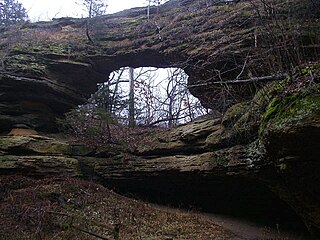
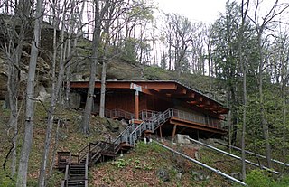
Natural Bridge State Park is a 530-acre (214 ha) state park of Wisconsin, United States, featuring Wisconsin's largest natural arch. Directly beneath the arch is the Raddatz Rockshelter, a rock shelter once used by Paleo-Indians and now listed on the National Register of Historic Places. The park is located southwest of Baraboo between the unincorporated communities of Leland and Denzer, in the town of Honey Creek.

Mile Canyon or more recently known as Eagle Nest Canyon is a tributary canyon of the Rio Grande entering on the north side of the river just downstream from Langtry, Texas. Mile Canyon received its name due to its length being approximately one mile long. In more recent years, this canyon is more commonly referred to as Eagle Nest Canyon, named after a nesting pair of golden eagles observed nearby. It has been an important area of many archaeological and geological expeditions over the past century.

Gatecliff Rockshelter (26NY301) is a major archaeological site in the Great Basin area of the western United States that provides remarkable stratigraphy; it has been called the "deepest archaeological rock shelter in the Americas". Located in Mill Canyon of the Toquima Range in the Monitor Valley of central Nevada, Gatecliff Rockshelter has an elevation of 7,750 feet (2,360 m). David Hurst Thomas discovered Gatecliff Rockshelter in 1970 and began excavations in 1971. Full scale excavations occurred at Gatecliff Rockshelter for about seven field seasons in which nearly 33 feet (10 m) of sediments were exposed for a well-defined stratigraphic sequence. The well-preserved artifacts and undisturbed sediments at Gatecliff Rockshelter provides data and information have been applied to a range of research topics. Based on the analysis of the artifacts at Gatecliff Rockshelter, it can be determined that it was most likely a short-term field camp throughout prehistory. The latest evidence for human usage at Gatecliff occurs between ca. 5500 B.P. to 1250 B.P.

The Furnace Hill Brook Historic and Archeological District in a historic district in Cranston, Rhode Island.

Graham Cave is a Native American archeological site near Mineola, Missouri in Montgomery County in the hills above the Loutre River. It is located in the 356 acre Graham Cave State Park. The entrance of the sandstone cave forms a broad arch 120 feet (37 m) wide and 16 feet (5 m) high. Extending about 100 feet (30 m) into the hillside, the cave protects an historically important Pre-Columbian archaeological site from the ancient Dalton and Archaic period dating back to as early as 10,000 years ago.
American Indian Rock Art in Minnesota MPS is a Multiple Property Submission (MPS) of the eligibility of many rock art properties for listing on the National Register of Historic Places. The listing is to protect and preserve Native American petroglyphs, pictographs and petroform rock art sites in the present day U.S. state of Minnesota.

The Pequot Fort was a fortified Native American village in what is now the Groton side of Mystic, Connecticut. Located atop a ridge overlooking the Mystic River, it was a palisaded settlement of the Pequot tribe until its destruction by English colonial and Native American forces in the 1637 Mystic massacre. The exact location of its archaeological remains is not certain, but it is commemorated by a small memorial at Pequot Avenue and Clift Street. The site previously included a statue of Major John Mason, who led the forces that destroyed the fort; it was somewhat controversially removed in 1995 after protests by Pequot tribal members. The archaeological site was added to the National Register of Historic Places in 1990.
The Calpet Rockshelter, also known as the Overlook Rockshelter and Archeological Site 48SU354 is an archeological site in Sublette County, Wyoming. The site includes an overhanging rock outcrop at the base of a butte that was used by Native Americans and European-Americans. The Native American use includes occupation by the Shoshone. A number of surface artifacts have been found and at least two buried cultural levels have been investigated from the Fremont and late Prehistoric-period Shoshone. Fremont, Prehistoric, Protohistoric and Historic-period visitation is documented at nine petroglyph panels.

The LoDaisKa Site is a prominent archaeological site in the U.S. state of Colorado, located within a rockshelter near Morrison. The rockshelter was first inhabited by people of the Archaic through the Middle Ceramic period, generally spanning 3000 BC to 1000 AD.

Franktown Cave is located 25 miles south of Denver, Colorado on the north edge of the Palmer Divide. It is the largest rock shelter documented on the Palmer Divide, which contains artifacts from many prehistoric cultures. Prehistoric hunter-gatherers occupied Franktown Cave intermittently for 8000 years beginning about 6400 B.C. The site held remarkable lithic and ceramic artifacts, but it is better known for its perishable artifacts, including animal hides, wood, fiber and corn. Material goods were produced for their comfort, task-simplification and religious celebration. There is evidence of the site being a campsite or dwelling as recent as AD 1725.

The Blackrock Springs Site (44-AU-167) is an archaeological site in Shenandoah National Park, in Augusta County, Virginia, United States.

The Paine Run Rockshelter (44-AU-158) is an archaeological site in Shenandoah National Park, in Augusta County, Virginia, United States.

The Rockhouse Cliffs Rockshelters are a pair of rockshelters in the far southern region of the U.S. state of Indiana. Located amid broken terrain in the Hoosier National Forest, the shelters may have been inhabited for more than ten thousand years by peoples ranging from the Early Archaic period until the twentieth century. As a result of their extensive occupation and their remote location, they are important and well-preserved archaeological sites and have been named a historic site.

The Hidden Valley Rockshelter (44-BA-31) is a significant archaeological site located near the community of Warm Springs in Bath County, Virginia, United States. A large rockshelter located near the Jackson River, it has been occupied by humans for thousands of years, and it has been named a historic site.
The LaGrange Rock Shelter is an archaeological site located on private property between Leighton and Muscle Shoals in Colbert County, Alabama, near the original campus of LaGrange College. The shelter measures 70 feet long by 15 feet deep and is located beneath a sandstone outcrop overlooking a dense series of Paleoindian sites in the valley below, which may have led to it being chosen for excavation.

Dry Creek Rockshelter near Boise, Idaho, is an archaeological site showing periodic use over approximately 3000 years. The site is located under a sandstone overhang, roughly 21 metres (69 ft) wide by 4 metres (13 ft) deep. The rockshelter is unique in that no other local sandstone outcrops are large enough for human habitation. The site was added to the National Register of Historic Places in 1991, and the site address is listed as restricted.
The Bennett Rockshelter is a prehistoric archaeological site in Old Lyme, Connecticut. It was an active campsite during the Woodland Period from approximately 0 CE to 1000 CE. The Bennett Rockshelter was added to the U.S. National Register of Historical Places in July 1987. The site is located on privately owned woodland.
