Fort Myer is the previous name used for a U.S. Army post next to Arlington National Cemetery in Arlington County, Virginia, and across the Potomac River from Washington, D.C. Founded during the American Civil War as Fort Cass and Fort Whipple, the post merged in 2005 with the neighboring Marine Corps installation, Henderson Hall, and is today named Joint Base Myer–Henderson Hall.

Fort Pillow State Historic Park is a state park in western Tennessee that preserves the American Civil War site of the Battle of Fort Pillow. The 1,642 acre (6.6 km²) Fort Pillow, located in Lauderdale County on the Chickasaw Bluffs overlooking the Mississippi River, is rich in both historic and archaeological significance. In 1861, the Confederate army built extensive fortifications and named the site for General Gideon Johnson Pillow of Maury County. It was attacked and held by the Union Army for most of the American Civil War period except immediately after the Battle of Fort Pillow, when it was retaken by the Confederate Army. The battle ended with a massacre of African-American Union troops and their white officers attempting to surrender, by soldiers under the command of Confederate Major General Nathan Bedford Forrest.

Fort Monroe is a former military installation in Hampton, Virginia, at Old Point Comfort, the southern tip of the Virginia Peninsula, United States. It is currently managed by partnership between the Fort Monroe Authority for the Commonwealth of Virginia, the National Park Service, and the city of Hampton as the Fort Monroe National Monument. Along with Fort Wool, Fort Monroe originally guarded the navigation channel between the Chesapeake Bay and Hampton Roads—the natural roadstead at the confluence of the Elizabeth, the Nansemond and the James rivers.

Fort Fisher was a Confederate fort during the American Civil War. It protected the vital trading routes of the port at Wilmington, North Carolina, from 1861 until its capture by the Union in 1865. The fort was located on one of Cape Fear River's two outlets to the Atlantic Ocean on what was then known as Federal Point or Confederate Point and today is known as Pleasure Island. The strength of Fort Fisher led to its being called the Southern Gibraltar and the "Malakoff Tower of the South". The battle of Fort Fisher was the most decisive battle of the Civil War fought in North Carolina.
The Battle of Fort Davidson, also known as the Battle of Pilot Knob, was a battle of Price's Missouri Expedition fought on September 27, 1864, near Pilot Knob, Missouri. Confederate troops under the command of Major-General Sterling Price had entered Missouri in September 1864 with hopes of challenging Union control of the state. On September 24, Price learned that Union troops held Pilot Knob. Two days later, he sent part of his command north to disrupt and then moved towards Pilot Knob with the rest of his army. The Confederate divisions of Major-General James Fagan and Brigadier-General John Marmaduke drove Union troops under Brigadier-General Thomas Ewing and Major James Wilson from the lower Arcadia Valley into Fort Davidson on September 26 and on the morning of September 27.
Fort Frederick State Park is a public recreation and historic preservation area on the Potomac River surrounding the restored Fort Frederick, a fortification active in the French and Indian War (1754–1763) and the American Revolutionary War (1775-1783). The state park lies south of the town of Big Pool, Maryland. The Chesapeake and Ohio Canal runs through the park grounds. The site was designated a National Historic Landmark in 1973.
The Fort Mill Ridge Civil War Trenches are battle trenches in West Virginia that were originally dug between 1861 and 1862 to be later used in 1863 for the civil war. These trenches lined with chestnut logs by the Confederate artillery during the American Civil War to defend the approaches to Romney on the Northwestern Turnpike and the South Branch Potomac River. The trenches were then refurbished between March and June 1863 by the 54th Pennsylvania Infantry and the 1st West Virginia Infantry. When Colonel Jacob M. Campbell garrisoned Union forces at Romney, camps were set up at nearby at Mechanicsburg Gap. The Confederates might have created these trenches but all throughout the war the Union had control of these trenches.

Fort Ethan Allen was an earthwork fortification that the Union Army built in 1861 on the property of Gilbert Vanderwerken in Alexandria County, Virginia, as part of the Civil War defenses of Washington. The remains of the fort are now within Arlington County's Fort Ethan Allen Park.
Fort Howell is an earthworks fort built in 1864 during the American Civil War, located on Hilton Head Island, South Carolina. It was named in honor of Union Army Brigadier General Joshua B. Howell, and Its primary function was to protect Mitchelville, a Freedman's town located to its east.

Fort C.F. Smith was a lunette that the Union Army constructed in Alexandria County, Virginia, during 1863 as part of the Civil War defenses of Washington. It was named in honor of General Charles Ferguson Smith, who died from a leg infection that was aggravated by dysentery on April 25, 1862. Fort C. F. Smith connected the Potomac River to the Arlington Line, a row of fortifications south of Washington, D.C., that was intended to protect the capital of the United States from an invasion by the Confederate States Army.

Fort Pickering is a 17th-century historic fort site on Winter Island in Salem, Massachusetts. Fort Pickering operated as a strategic coastal defense and military barracks for Salem Harbor during a variety of periods, serving as a fortification from the Anglo-Dutch Wars through World War II. Construction of the original fort began in 1643 and it saw use as a military installation into the 20th century. Fort Miller in Marblehead also defended Salem's harbor from the 1630s through the American Civil War. Fort Pickering is a First System fortification named for Colonel Timothy Pickering, born in Salem, adjutant general of the Continental Army and secretary of war in 1795. Today, the remains of the fort are open to the public as part of the Winter Island Maritime Park, operated by the City of Salem.
The Port Hudson State Historic Site is located on the Mississippi River north of Baton Rouge in East Feliciana Parish, Louisiana, just outside the limits of Port Hudson and in the vicinity of Jackson. The site preserves a portion of the fortifications and battle area of the longest siege in American history, during the American Civil War from May 23 through July 9, 1863. The state of Louisiana maintains the site, which includes a museum about the siege, artillery displays, redoubts, and interpretive plaques. Historical reenactments are held each year. It was designated a National Historic Landmark in 1974, significant as the first place where African-American military units fought for the Union Army under African-American field leadership.

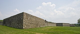
Fort Davidson, a fortification near the town of Pilot Knob, Missouri, was the site of the Battle of Fort Davidson during the American Civil War. Built by Union Army soldiers during the American Civil War, the fort repulsed Confederate attacks during the Battle of Fort Davidson on September 27, 1864, during Price's Raid. That night, the Union garrison blew up the fort's magazine and abandoned the site. A mass grave was constructed on the site to bury battlefield dead. After the war, the area was used by a mining company, before passing into private hands and eventually the administration of the United States Forest Service. In 1968, the Battle of Pilot Knob State Historic Site was created as a Missouri State Park. The fort itself was added to the National Register of Historic Places in 1970. As of 2020, a visitors center containing a museum is located within the park. The museum contains a fiber optic display, as well as artifacts including Brigadier General Thomas Ewing Jr.'s sword. The fort's walls are still visible, as is the crater created when the magazine was detonated. A monument marks the location of the mass grave.
Fort Hovey was a small Civil War era earth-and-wood fort built on a hill overlooking the junction of the road running south out of Ironton, Missouri and the road running east to Fredericktown, Missouri. Fort Hovey was intended to help protect the Arcadia Valley and the iron mines located on Pilot Knob. The fort was located on Fort Hill near the town of Arcadia, Missouri on the (then) property of the Fort Hill Methodist Episcopal Church, South and the present day Arcadia Valley United Presbyterian Church. This fortification was named Fort Hovey in honor of the commander of the 33rd Illinois Volunteer Infantry Regiment (Union), Colonel Charles E. Hovey. The 33rd. Illinois was stationed there during the Autumn and Winter of 1861-62, at which time they built the fort.

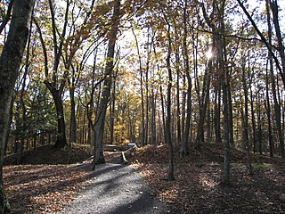
Old Town is an archaeological site in Williamson County, Tennessee near Franklin. The site includes the remnants of a Native American village and mound complex of the Mississippian culture, and is listed on the National Register of Historic Places (NRHP) as Old Town Archaeological Site (40WM2).

Fort Granger was a Union fort built in 1862 in Franklin, Tennessee, south of Nashville, after their forces occupied the state during the American Civil War. One of several fortifications constructed in the Franklin Battlefield, the fort was used by Union troops to defend their positions in Middle Tennessee against Confederate attackers. The Second Battle of Franklin in 1864, part of the Franklin-Nashville Campaign in the Western Theater, was the most notable engagement of this area during the Civil War.
Winstead Hill is a property in Franklin, Tennessee that has significance in 1864 for being in the Second Battle of Franklin battlefield. It is located within the Franklin Battlefield, a U.S. National Historic Landmark area.
Triune Fortification is a historic site in or near Arrington, Tennessee that was listed on the National Register of Historic Places in 1999. It has significance from American Civil War activity there in 1863. When listed the property included four contributing structures and ten non-contributing buildings on 502 acres (203 ha).

Blue Springs Encampments and Fortifications is the site of a Civil War military encampment in Bradley County, Tennessee. Union Army forces commanded by General William Tecumseh Sherman camped at this location between October 1863 and April 1865. Entrenchments built on the crests of ridges overlooking the camps are still visible on the site. Stone reinforcements are present in some sections of the entrenchments.

