
Multnomah Falls is a waterfall located on Multnomah Creek in the Columbia River Gorge, east of Troutdale, between Corbett and Dodson, Oregon, United States. The waterfall is accessible from the Historic Columbia River Highway and Interstate 84. Spanning two tiers on basalt cliffs, it is the tallest waterfall in the state of Oregon at 620 ft (189 m) in height. The Multnomah Creek Bridge, built in 1914, crosses below the falls, and is listed on the National Register of Historic Places.

The George Washington Memorial Parkway, colloquially the G.W. Parkway, is a 25-mile-long (40 km) limited-access parkway that runs along the south bank of the Potomac River from Mount Vernon, Virginia, northwest to McLean, Virginia, and is maintained by the National Park Service (NPS). It is located almost entirely in Northern Virginia, except for a short portion of the parkway northwest of the Arlington Memorial Bridge that passes over Columbia Island in Washington, D.C.

The Tower Bridge is a vertical lift bridge across the Sacramento River, linking West Sacramento in Yolo County to the west, with the capital of California, Sacramento, in Sacramento County to the east. It has also been known as M Street Bridge. It was previously a part of U.S. Route 40 until that highway was truncated to east of Salt Lake City as well as US Route 99W, which served the western portion of the Sacramento Valley from Sacramento to Red Bluff. The bridge is maintained by the California Department of Transportation as part of State Route 275 and connects West Capitol Avenue and Cabaldon Parkway in West Sacramento with the Capitol Mall in Sacramento.

The Fairfax Bridge is a steel-lattice three-hinged arch bridge spanning the Carbon River on State Route 165 in Pierce County, Washington. Previous to the construction of the bridge in 1921, the only route south to the area around Fairfax was by train. At a total cost of $80,000, the bridge's deck sits 250 feet (76 m) above the river. Being a single-lane bridge, vehicles must yield to oncoming traffic already on the bridge.

The Beverly Railroad Bridge is a historic railroad bridge that now carries hikers, bicyclists, and pedestrians over the Columbia River near Beverly, Washington, United States. It was constructed by the Chicago, Milwaukee, St. Paul and Pacific Railroad in 1909 during its Pacific Extension. In 1906, The Milwaukee Road began construction on its transcontinental rail line from Chicago, Illinois to Tacoma, Washington, which was completed three years later.
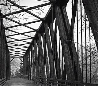
The Dungeness River Bridge is the centerpiece of Railroad Bridge Park near the town of Sequim, Washington. It crosses the Dungeness River. The bridge was first constructed by the Seattle, Port Angeles, and Western Railway, a subsidiary of the Chicago, Milwaukee, St. Paul and Pacific Railroad in 1916. Because of the ready availability of timber, the bridge was built of wood. This first bridge was replaced in 1930. The new bridge was also built of timber, and like its predecessor, is a through Howe truss 156 feet long and 22 feet high. Two wooden trestles are on the east and west approaches.

The B & O Railroad Potomac River Crossing is a 15-acre (6.1 ha) historic site where a set of railroad bridges, originally built by the Baltimore and Ohio Railroad, span the Potomac River between Sandy Hook, Maryland and Harpers Ferry, West Virginia. The site was added to the National Register of Historic Places on February 14, 1978, for its significance in commerce, engineering, industry, invention, and transportation.

The Zion – Mount Carmel Highway is a 25-mile (40 km) long road in Washington and Kane counties in southern Utah, United States, that is listed on the National Register of Historic Places and is a National Historic Civil Engineering Landmark.

The Kettle Falls Bridges is the collective name for a pair of steel cantilever bridges carrying State Route 20/U.S. Route 395 and the Kettle Falls International Railway across the Columbia River at Kettle Falls, Washington. The south bridge carries motor vehicle traffic while the similar northern span is used for rail.

The Grand Coulee Bridge, or Columbia River Bridge at Grand Coulee Dam, is a through-cantilever steel truss bridge built in 1934–35. It carries State Route 155 across the Columbia River immediately below Grand Coulee Dam, near the city of Grand Coulee, Washington. It was added to the National Register of Historic Places in 1982.

The Yale Bridge or Lewis River Bridge spans the Lewis River near Yale, Washington. It was built in 1932 by Cowlitz and Clark counties. The suspension bridge has a clear span of 300 feet (91 m), with a total length of 532 feet (162 m), replacing a previous steel truss bridge at the site. Construction of the Ariel Dam had created Lake Merwin with a water depth of 90 feet (27 m) at the site, requiring a new bridge that did not need to have support piers in the water. The road deck, stiffened by a steel Warren truss, is 50 feet (15 m) above the high water line of the reservoir.

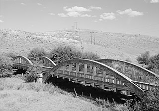
The Columbia River Bridge at Wenatchee, Washington, also known as the Old Wenatchee Bridge and W.T. Clark Pipeline Bridge was built by the Washington Bridge Company in 1908, primarily as a means to carry irrigation water pipelines across the Columbia River. It was the first road bridge over the Columbia south of Canada. The bridge is a pin-connected cantilever truss, 1,600 feet (490 m) long, with one 200-foot (61 m) Pratt truss between two 160-foot (49 m) cantilever arms, with 240-foot (73 m) side arms and a 60 feet (18 m) girder span. The bridge was purchased by the Washington highway department for $182,000 for highway use. As originally built, the bridge carried a 20.5-foot (6.2 m) wide timber roadway, with additional ability to carry a street railway. However, the east approach to the bridge was built at a 6% grade, limiting its potential.
Patton Bridge is a bridge located in Auburn, Washington listed on the National Register of Historic Places. The bridge spans the Green River near metropolitan Auburn, Washington. It was designed by bridge engineer and designer Homer M. Hadley. The combination of concrete and steel box girders employed in the bridge's represents a variation of the box girder bridge style. The Patton Bridge was the only structure built between 1941 and 1950, which exhibits this innovative modification of the box girder design.
The Jefferson Street Viaduct is a historic structure located in Ottumwa, Iowa, United States. The riveted Warren deck truss bridge was completed in 1936. It was listed on the National Register of Historic Places in 1998 as a part of the Highway Bridges of Iowa MPS.

The North 21st Street Bridge in Tacoma, Washington was built in 1910. It was designed by engineers Waddell & Harrington and is a continuous concrete rigid-frame girder bridge. It is significant as one of the very earliest examples of its type. It was built "almost simultaneously" with the 950-foot (290 m) Asylum Avenue Aqueduct in Knoxville, Tennessee, which was documented by Carl W. Condit to be the first continuous concrete girder bridge to be built.

The Vance Creek Bridge is an arch bridge in the Satsop Hills of Mason County, Washington that was built for a logging railroad owned by the Simpson Logging Company in 1929. At 347 feet (106 m) in height, it is the second-highest railroad arch in the United States after the nearby High Steel Bridge. It was decommissioned in the 1970s, during the decline of logging on the Olympic Peninsula.
The Indian Timothy Memorial Bridge is a tied-arch bridge which spans Alpowa Creek less than half a mile before that creek joins the Snake River, about 8 miles (13 km) west of Clarkston in Asotin County, Washington. It was built by the Washington State Department of Transportation in 1923 and was listed on the National Register of Historic Places in 1982.

The Orient Bridge, which spans the Kettle River between Ferry County, Washington and Stevens County, Washington, was built in 1909. It was listed on the National Register of Historic Places.

The Manning-Rye Covered Bridge, spanning the Palouse River near Colfax, Washington, was built around 1918. It was listed on the National Register of Historic Places in 1982. It has also been known as the Harpole Bridge.

The East Navidad River Bridge, also known as the State Highway 3 Bridge at East Navidad River, is a historic concrete bridge that carries FM 1579 across the East Navidad River about 3.4 miles (5.5 km) east of Schulenberg in Fayette County, Texas. The 199-foot-long (61 m) cantilever bridge has a 70-foot (21 m) center span. Concrete piers and abutments support the two cantilever arms. The total width of the bridge is 21.17 feet (6.45 m), providing an 18-foot-wide (5.5 m) roadway. The bridge gives the appearance of an arch but is in fact two cantilevered arms joined in the center of the main span and anchored and countered at the ends. Concrete piers with skewed abutments provide support.


