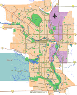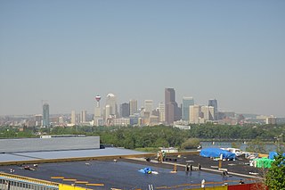
Bankview is a neighbourhood in the southwest quadrant of the city of Calgary, Alberta.

Mount Royal is an area of Calgary, Alberta and is home to the neighbourhoods of Upper Mount Royal and Lower Mount Royal, which are separated by an escarpment that runs along Cameron and Royal Avenues in an east-west direction. Upper Mount Royal has an area redevelopment plan in place.

Albert Park/Radisson Heights is a residential neighbourhood in the south-east quadrant of Calgary, Alberta. It is bounded to the west by the Bow River and Deerfoot Trail, to the north by Memorial Drive and to the south by 17 Avenue SE. The community of Forest Lawn lies to the east.

Buena Vista is a residential neighbourhood located near the centre of Saskatoon, Saskatchewan, Canada. It is an older suburban subdivision, including mostly low-density, single detached dwellings. As of 2011, the area is home to 3,271 residents. The neighbourhood is considered a middle-income area, with an average family income of $67,170, an average dwelling value of $251,560 and a home ownership rate of 77.7%.

Midnapore is a community within the City of Calgary in the province of Alberta, Canada. It is bounded to the north and east by Fish Creek Provincial Park, to the south by Sun Valley Boulevard and to the west by Macleod Trail.

Altadore is a residential neighbourhood in the inner-city portion of the southwest quadrant of Calgary, Alberta. It is located between 14 Street and Crowchild Trail, south of the neighbourhood of South Calgary. It is bordered by the Elbow River and the River Park to the southeast.

Forest Lawn is a neighbourhood and former town in the southeast quadrant of the city of Calgary, Alberta, Canada. The neighbourhood is bound by 26 Avenue SE to the south, 36 Street SE to the west, 8 Avenue SE to the north and portions of 52 Street SE and 48 Street SE to the east. The former town comprises the entire current Forest Lawn neighbourhood as well as portions of Southview and Albert Park/Radisson Heights to the west, and portions of Penbrooke Meadows and Forest Lawn Industrial to the east. Both the neighbourhood and the former town are bisected by the multicultural 17 Avenue SE. Forest Lawn has an area redevelopment plan in place and is part of the International Avenue Business Revitalization Zone.

Lincoln Park is a neighbourhood in the southwest quadrant of Calgary, Alberta located north of Glenmore Trail and west of Crowchild Trail. Notable landmarks in the neighbourhood include Mount Royal University and the ATCO Industrial Park. The neighbourhood is located on the section of the former Canadian Forces Base Calgary that during World War II was a Royal Canadian Air Force airfield; the name of the district derives from a small area of military housing located between 54th Avenue S.W. and Glenmore Trail which was reserved for United States Air Force members stationed at the airfield during World War II.

Chinook Park is a residential neighbourhood in the southwest quadrant of Calgary, Alberta. It is bounded by Glenmore Trail to the north, Elbow Drive to the east, 14 Street W to the west and Heritage Drive to the south.

Vista Heights is a residential neighbourhood in the north-east quadrant of Calgary, Alberta. It is bounded to the south by the Trans-Canada Highway and to the west by Deerfoot Trail. To the north and east it borders the South Airways Industrial Area.

Christie Park is a residential neighbourhood in the southwest quadrant of Calgary, Alberta. It is bounded by Strathcona Drive and the community of Strathcona Park to the north, Sarcee Trail to the east, 17 Avenue S to the south and 69 Street W to the west.

Thorncliffe is a residential neighbourhood in the north-east quadrant of Calgary, Alberta. It is bounded by 64 Avenue to the north, Deerfoot Trail to the east, McKnight Boulevard to the south and 14 Street W and Nose Hill Park to the west.

Cougar Ridge is a residential neighbourhood in the southwest quadrant of Calgary, Alberta. It is located at the western edge of the city and is bounded by Paskapoo Slopes and Canada Olympic Park to the north, 69 Street W to the east, 101 Street W to the west and Old Banff Coach Road to the south.

Evanston is a residential neighbourhood in the northwest quadrant of Calgary, Alberta. Located near the north edge of the city, it is bounded by the Kincora community across Shaganappi Trail to the southwest, the Sage Hill community to the west, Sarcee Trail to the west, 144 Avenue N.W. to the north, 14 Street N.W. to the east, and the Panorama Hills and Hidden Valley communities across Stoney Trail to the southeast and south. It is one of five communities located within the Symons Valley area.

Mayland Heights is a residential neighbourhood in the north-east quadrant of Calgary, Alberta. It is bounded by Barlow Trail to the east, Memorial Drive to the south, Deerfoot Trail to the west and Trans-Canada Highway to the north.

Royal Oak is a residential neighbourhood in the north-west quadrant of Calgary, Alberta. It is located close to the north-western edge of the city and is bounded to the north by Country Hills Boulevard, to the east by Stoney Trail, to the south by Crowchild Trail and to the west by Rocky Ridge Road. Royal Oak is located near Rocky Ridge, Calgary

Cranston is a master planned residential community in the south-east quadrant of Calgary, Alberta. Cranston contains a wide range of single family and multi family residential as well as commercial property. It has one public elementary school and one separate board K-9 school, as well as Century Hall - a private Cranston residents recreation facility. It is bounded by Stoney Trail to the north and Fish Creek Park and the Bow River to the west and south. Its eastern boundary is Deerfoot Trail and the community of Auburn Bay and the mixed use town centre development of Seton and South Health Campus hospital. It is represented in the Calgary City Council by the Ward 12 councillor.

CFB Lincoln Park PMQ is a residential neighbourhood in the southwest quadrant of Calgary, Alberta, Canada. It is located on former Canadian Forces Base (CFB) Calgary, bounded by Richardson Road S.W. to the west, Glenmore Trail to the south, Crowchild Trail to the east, and the Lincoln Park community to the north. The neighbourhood is referred to as Lincoln Park South in the CFB West Master Plan and consists of the CFB Calgary's former Lincoln Park Permanent Marital Quarters (PMQ).


