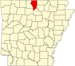
Salesville, Arkansas | |
---|---|
Coordinates: 36°14′41″N92°16′32″W / 36.24472°N 92.27556°W | |
Country | United States |
State | Arkansas |
County | Baxter |
Named for | John Sales, first settler [1] |
Area | |
• Total | 4.52 sq mi (11.70 km2) |
• Land | 4.51 sq mi (11.69 km2) |
• Water | 0.00 sq mi (0.00 km2) |
Elevation | 656 ft (200 m) |
Population (2020) | |
• Total | 473 |
• Density | 104.76/sq mi (40.45/km2) |
Time zone | UTC-6 (Central (CST)) |
• Summer (DST) | UTC-5 (CDT) |
ZIP code | 72653 |
Area code | 870 |
FIPS code | 05-62240 |
GNIS feature ID | 2405406 [3] |
Salesville is a city in Baxter County, Arkansas, United States. The population was 450 in 2010. [4]
Salesville is located in central Baxter County at 36°14′41″N92°16′32″W / 36.24472°N 92.27556°W (36.244845, -92.275619). [5] The center of town is at the intersection of Arkansas Highway 5 and 177, 1.5 miles (2.4 km) west of Norfork Dam. The North Fork River, after coming out of the dam, forms the eastern boundary of Salesville. Arkansas Highway 5 leads northwest 10 miles (16 km) to Mountain Home, the county seat, and south 3 miles (5 km) to the city of Norfork and 38 miles (61 km) to Mountain View.
According to the United States Census Bureau, the city has a total area of 4.5 square miles (11.6 km2), all land. [4]
Salesville is in the Norfork School District with students graduating from Norfork High School. [6]
Census | Pop. | Note | %± |
---|---|---|---|
1970 | 156 | — | |
1980 | 406 | 160.3% | |
1990 | 374 | −7.9% | |
2000 | 437 | 16.8% | |
2010 | 450 | 3.0% | |
2020 | 473 | 5.1% | |
U.S. Decennial Census [7] |
As of the census [8] of 2000, there were 437 people, 206 households, and 131 families residing in the city. The population density was 97.7 inhabitants per square mile (37.7/km2). There were 267 housing units at an average density of 59.7 per square mile (23.1/km2). The racial makeup of the city was 95.42% White, 1.37% Native American, 0.23% Asian, 0.69% from other races, and 2.29% from two or more races. 1.60% of the population were Hispanic or Latino of any race.
There were 206 households, out of which 20.9% had children under the age of 18 living with them, 56.3% were married couples living together, 5.8% had a female householder with no husband present, and 36.4% were non-families. 33.5% of all households were made up of individuals, and 17.0% had someone living alone who was 65 years of age or older. The average household size was 2.12 and the average family size was 2.72.
In the city, the population was spread out, with 17.8% under the age of 18, 4.3% from 18 to 24, 23.6% from 25 to 44, 31.1% from 45 to 64, and 23.1% who were 65 years of age or older. The median age was 48 years. For every 100 females, there were 94.2 males. For every 100 females age 18 and over, there were 87.0 males.
The median income for a household in the city was $23,542, and the median income for a family was $33,611. Males had a median income of $29,531 versus $17,250 for females. The per capita income for the city was $17,077. About 9.8% of families and 12.9% of the population were below the poverty line, including 13.3% of those under age 18 and 13.8% of those age 65 or over.
Stone County is located in the Ozark Mountains in the U.S. state of Arkansas. The county is named for rugged, rocky area terrain of the Ozarks. Created as Arkansas's 74th county on April 21, 1873, Stone County has two incorporated cities: Mountain View, the county seat and most populous city, and Fifty-Six. The county is also the site of numerous unincorporated communities and ghost towns.
Sharp County is a county located in the U.S. state of Arkansas. As of the 2020 census, the population was 17,271. The county seat is Ash Flat. The county was formed on July 18, 1868, and named for Ephraim Sharp, a state legislator from the area.
Searcy County is a county located in the U.S. state of Arkansas. As of the 2020 census, the population was 7,828. The county seat is Marshall. The county was formed December 13, 1838, from a portion of Marion County and named for Richard Searcy, the first clerk and judge in the Arkansas Territory. The city of Searcy, Arkansas, some 70 miles away, shares the name despite having never been part of Searcy County. The county is an alcohol prohibition or dry county.
Marion County is located in the Ozark Mountains in the U.S. state of Arkansas. The county is named for Francis Marion, the famous "Swamp Fox" of the Revolutionary War. Created as Arkansas's 35th county in 1836, Marion County is home to one incorporated town and four incorporated cities, including Yellville, the county seat. The county is also the site of numerous unincorporated communities and ghost towns. The county included part of what is now Searcy County, Arkansas, with many opposing to dividing them, which helped fueled the bloody Tutt-Everett War between 1844 and 1850.
Izard County is a county located in the U.S. state of Arkansas. As of the 2020 census, the population was 13,577. The county seat is Melbourne. Izard County is Arkansas's 13th county, formed on October 27, 1825, and named for War of 1812 General and Arkansas Territorial Governor George Izard. It is an alcohol prohibition or dry county.
Fulton County is a county located in the U.S. state of Arkansas. As of the 2020 census, the population was 12,075. The county seat is Salem. Fulton County was formed on December 21, 1842, and named for William Fulton, the last governor of the Arkansas Territory. It is an alcohol prohibition or dry county.
Conway County is a county located in the U.S. state of Arkansas. Created as Arkansas's 11th county on October 20, 1825, Conway County has four incorporated municipalities, including Morrilton, the county seat and most populous city. The county is also the site of numerous unincorporated communities and ghost towns. The county is named for Henry Wharton Conway, a politician from a powerful political family who served as the delegate from the Arkansas Territory to the U.S. Congress from 1823 to 1827.
Cleburne County is a county located in the U.S. state of Arkansas. As of the 2020 census, the population was 24,711. The county seat and most populous city is Heber Springs. The county was formed on February 20, 1883, as the last of Arkansas's 75 counties to be formed. It is named for Confederate Major-General Patrick Cleburne. Cleburne is an alcohol prohibition or dry county.
Baxter County is a county in the U.S. state of Arkansas. As of the 2020 census, the county's population was 41,627. The county seat is Mountain Home. It is Arkansas's 66th county, formed on March 24, 1873, and named for Elisha Baxter, the tenth governor of Arkansas.
Big Flat is a town in Baxter and Searcy counties in the U.S. state of Arkansas. The population was 88 at the 2020 census.
Briarcliff is a second-class city in Baxter County, Arkansas, United States. The population was 236 at the 2010 census.
Gassville is a city in Baxter County, Arkansas, United States. According to the 2020 census, the city population was 2,171.
Lakeview is a city in Baxter County, Arkansas, United States. The population was 741 at the 2010 census.
Mountain Home is a city in and the county seat of Baxter County, Arkansas, United States, in the southern Ozark Mountains near the northern state border with Missouri. As of the 2010 census, the city had a population of 12,448. A total of 41,307 persons lived within the city and micropolitan area combined, which encompasses the majority of Baxter County.
Norfork is a city in Baxter County, Arkansas, United States. The population was 550 at the 2010 census.
Decatur is a city, in Benton County, Arkansas, United States. The population was 1,773 at the 2020 census. It is part of the Northwest Arkansas region. This town is named after Commodore Stephen Decatur, Jr.
Guy is a city in Faulkner County, Arkansas, United States. The population was 708 at the 2010 census, up from 202 at the 2000 census. It is part of the Central Arkansas region.
Holland is a city in Faulkner County, Arkansas, United States. The population was 557 at the 2010 census. It is part of the Central Arkansas region.
Salem is the county seat of Fulton County, Arkansas, United States. Salem was first incorporated in 1900. As of the 2010 census the population stood at 1,635.
Calico Rock is a city in Izard County, Arkansas, United States. The population was 1,545 at the 2010 census, up from 991 in 2000.