
Buxton is a town in York County, Maine, United States. It is part of the Portland metropolitan area. The population was 8,376 at the 2020 census. Buxton includes the villages of Salmon Falls/Tory Hill, Chicopee, Groveville, Bar Mills, West Buxton, and Buxton Center. The old town Common is east of Union Falls, which is the location of Skelton Dam, operated by Central Maine Power, and near historic location of the original settlement at Pleasant Point.

Dayton is a town in York County, Maine, United States; the town is located near the Saco-Biddeford city area. Dayton borders Biddeford by land, and borders Saco on the Saco River. It is also part of the Portland–South Portland–Biddeford, Maine metropolitan statistical area. The population was 2,129 at the 2020 census. Dayton is one of the smallest towns in York County.

Hollis is a town in York County, Maine, United States. The population was 4,745 at the 2020 census. Hollis is a rural bedroom community of Portland and is part of the Portland–South Portland–Biddeford metropolitan statistical area.

Saco is a city in York County, Maine, United States. The population was 20,381 at the 2020 census. It is home to Ferry Beach State Park, Funtown Splashtown USA, Thornton Academy, as well as General Dynamics Armament Systems, a subsidiary of the defense contractor General Dynamics. Saco sees much tourism during summer months due to its amusement parks, Camp Ellis Beach and Pier, Ferry Beach State Park, and proximity to Old Orchard Beach.

The High Falls Historic District corresponds roughly to the downtown section of the hamlet of that name in Marbletown, New York, United States. It is a 21-acre (8.5 ha) area around the intersection of state highway NY 213, Main Street, Mohonk Road (Ulster County Route 6A0 and Bruceville Road just south of Rondout Creek.
Gibeon Elden Bradbury (1833–1904) was a painter from Buxton, Maine. Bradbury was born in a particular section of Buxton entitled Salmon Falls, an area on a large hill near the Saco River. The son of Nathaniel Scamman Bradbury and Lucy Sawyer Bradbury, Gibeon spent most of his life in Salmon Falls.

The South Britain Historic District encompasses the core of the unincorporated village of South Britain in Southbury, Connecticut, United States. The village arose in the 18th century as an industrial center serving the surrounding agricultural community, powered by the Pomperaug River, and rivalled the town center of Southbury in importance. The district was listed on the National Register of Historic Places in 1987.

Newington Junction is a section of the town of Newington, Connecticut, United States. It is centered at the intersection of Willard Avenue and West Hill Road in the northwestern part of the town, in the area generally just south of the Hartford city line. The name of the area refers to the railroad junction where the railroad line from New Haven meets with the railroad line from Bristol and Waterbury. The development of Newington Junction as a result of the railroad was instrumental in the separation of the town of Newington from its mother town of Wethersfield.
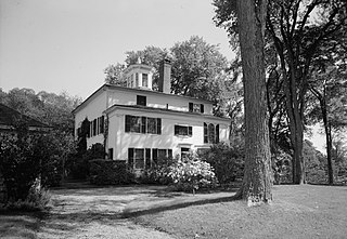
The Kate Douglas Wiggin House, also known as Quillcote, is a historic house on Salmon Falls Road in Hollis, Maine. Built in 1797, the house is significant as the home of the writer Kate Douglas Wiggin from 1905 until her death in 1923, and as a fine example of adaptive architectural change over time. One room of the house features wall murals attributed to Rufus Porter. The house was listed on the National Register of Historic Places in 1977.

The Saco Historic District encompasses the historic commercial and residential centers of Saco, Maine. Covering more than 100 acres (40 ha) of central Saco, it includes houses from the 18th through 20th centuries, and the main business district along Main Street. It was added to the National Register of Historic Places in 1998.

The Orford Street Historic District encompasses a particularly attractive stretch of Orford Street in Orford, New Hampshire. It was described as early as the 18th century as "the most charming country village", with a tree-lined promenade that is still a focus of the town center. The district consists of about 0.5 miles (0.80 km) of Orford Street, between its junctions with New Hampshire Route 25A and Archertown Road, and was listed on the National Register of Historic Places in 1977.

The Newichawannock Canal is a man-made canal which drains Great East Lake into Horn Pond at the border between Wakefield, New Hampshire, and Acton, Maine, in the northeastern United States. It is at the head of the Salmon Falls River, which the Abenaki called Newichawannock, meaning "river with many falls". Begun in 1850 by the Great Falls Company to increase the water available for its mills in Somersworth, New Hampshire, the 0.75-mile (1.21 km) canal is unusual as it was built for strictly industrial purposes in an area remote from the actual industrial site. The canal forms the boundary between the states of New Hampshire and Maine, and is spanned by a stone bridge built at the same time. The canal and bridge, along with related artifacts, were listed on the National Register of Historic Places in 2014.

The Carrabasset Inn is a historic house at the northwest corner of the junction of Union Street and River Road in North Anson, Maine. Built as a private residence c. 1850, the house was altered significantly for use as a hotel after a fire devastated North Anson's business district, and served in that role as the village's only hotel into the 1940s. It now exhibits an architecturally distinctive blend of Greek Revival, Colonial Revival, and Craftsman styling. It was listed on the National Register of Historic Places in 2000. It is now a private residence.

Elden's Store is a historic commercial building on Long Plains Road in the center of Buxton, Maine. Built in 1802, it is the oldest commercial building in the rural community, and is one of the few historic brick commercial buildings in western York County. The building, which is now owned by the local historical society, was listed on the National Register of Historic Places in 1983.
The Dennysville Historic District encompasses the historic town center of Dennysville, Maine. Located near the southern end of the large rural community, its architecture covers more than 100 years of community history, from the early 19th to early 20th centuries. The district extends along Main Street between Maine State Route 86 and Bunker Hill Road, on the west bank of the Dennys River. It was listed on the National Register of Historic Places in 1982.

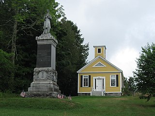
The Salmon Falls (West) Historic District encompasses a cluster of well-preserved buildings built before 1840, and located on the Hollis, Maine side of the rural village of Salmon Falls. In addition to its architectural significance, the area is also noted for its association with the author Kate Douglas Wiggin, whose home, Quillcote, is in the district, as is the Salmon Falls Library, established by her efforts in 1911. The district was listed on the National Register of Historic Places in 1987.

The South Berwick Village Historic District encompasses the historic village center of South Berwick, Maine. First settled in the 1640s, the village developed along a major route between Boston, Massachusetts and Portland, Maine in the early 19th century. The village has about 150 years of architecture reflective of this history, and was listed on the National Register of Historic Places in 2010.

The Thacher-Goodale House is a historic house at 121 North Street in Saco, Maine. Built in 1827, it is a sophisticated early expression of Greek Revival architecture, retaining significant Federal period details. Built for George Thacher, Jr., a lawyer, it was owned for many years by members of the Goodale family, most notably the botanist George Lincoln Goodale. The house was listed on the National Register of Historic Places in 1976.

The Days Ferry Historic District encompasses a rural village that grew around a ferry crossing on the Kennebec River in what is now Woolwich, Maine. The village and ferry were on the main stage route between Bath and Wiscasset until the 1870s, and retains a concentration of well-preserved 18th and early 19th-century houses. The district was listed on the National Register of Historic Places in 1975.
The Topsham Historic District encompasses the historic village center of Topsham, Maine. Extending along parts of Elm, Green, and Pleasant Streets, the area has a fine collection of 19th and early 20th-century architecture, with the majority built before 1850. It is almost entirely residential, with only a few non-residential uses, including a church. The district was listed on the National Register of Historic Places in 1978.


