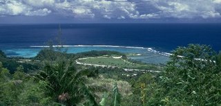
The War in the Pacific National Historical Park is a protected area in the United States territory of Guam, in Apra Harbor, which was established in 1978 in honor of those who participated in the Pacific Theater of World War II. Various sites on the island of Guam are part of the Park. It is unique among the National Park System insofar as it honors the bravery and sacrifices of all those who participated in the Pacific Theater.

This is a list of the buildings, sites, districts, and objects listed on the National Register of Historic Places in Guam. There are currently 132 listed sites spread across 17 of the 19 villages of Guam. The villages of Agana Heights and Mongmong-Toto-Maite do not have any listings.
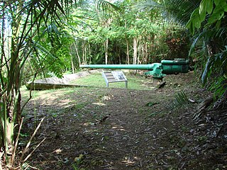
The Piti Guns or Piti Coastal Defense Guns is the site of three Vickers-type Model 3 140-millimetre (5.5 in) coastal defense guns in the War in the Pacific National Historical Park in Piti, Guam. The Japanese manufactured these Model 3 coastal defense guns in 1914. During the Japanese Occupation of Guam from 1941–1944, they built up defensive positions on the island. The Chamorro population was forced to work in building up these defenses, and did so here at the Piti Guns.
The Ilik River Fortification II near Yona, Guam was built by Japanese forces during World War II. It was listed on the U.S. National Register of Historic Places in 1991.
The As Sombreru Pillbox I, As Sombreru Pillbox II, and As Sombreru Pillbox III are three historic defensive fortifications on Guam, near Tumon, that were listed on the U.S. National Register of Historic Places in 1991. They are pillboxes, a type of defensive fortification, built by the 48th Independent Mixed Brigade; 29th Division of the Imperial Japanese Army during 1941-1944, between Japan capturing Guam on December 8, 1941 from the United States and the U.S. recapturing Guam in 1944.

The Ha. 62-76 Japanese Midget Submarine, now located at US 1, in front of the War in the Pacific Museum in Comnavmarianas, Guam, was built in 1944. It is a Type C Kō-hyōteki-class submarine (甲標的丙型) built by Ōurazaki, Kure. It was captured during World War II, after it ran aground on Togcha Beach, near Ipan Talofofo, Guam, in 1944. Its crew surrendered three days later.

Cetti Bay is an oceanic bay and historic site near Umatac, Guam, that is listed on the National Register of Historic Places.

The Agat Invasion Beach is a historic site in the village of Agat, Guam. The beaches of Agat were one of the landing sites of American forces in the 1944 Battle of Guam, in which the island was retaken from occupying Japanese forces. The designated historic site includes the beaches and inland areas extending between Bangi Point and Togcha Beach. Surviving remnants of the Japanese defenses on this stretch of coast include trenches and rifle pits located a short way inland, and a fortified bunker and 40mm gun emplacements at Ga'an Point. Remnants of pillboxes that had lined the beach also survive, with one at Gangi Point in relatively good condition.

The Agat World War II Amtrac is an underwater relic of World War II, located off Ga'an Point on the west side of the island of Guam. It is the remains of an LVT 4, an amphibious tracked landing vehicle. It is located about 500 yards (460 m) off the beach in 45 feet (14 m) of water, and was described as being in good condition when it was discovered and surveyed in 1985. These vehicles were used during the 1944 Battle of Guam, in which American forces recaptured the island from occupying Japanese forces. This particular vehicle does not appear to exhibit significant war damage. It is administratively part of the War in the Pacific National Historical Park.

The Asan Invasion Beach is a historic site in the village of Asan, Guam. The beaches of Asan
were one of the landing sites of American forces in the 1944 Battle of Guam, in which the island was retaken from occupying Japanese forces. The designated historic site includes the beaches extending between Asan Point and Adelup Point, and extends inland roughly to Guam Highway 1. It also includes the water area extending from the beach to the reef, about 100 metres (330 ft) out, an area that includes at least one abandoned Allied landing vehicle.
The Dungcas Beach Defense Guns are an old World War II Japanese fortification in the United States territory of Guam. It consists of a tunnel dug in the coral limestone of the cliffs overlooking the beach on the northeast east side of Hagåtña Bay on the west side of the island. The tunnel has two guns mounted at openings facing the beach. This fortification was built by the 48th Independent Mixed Brigade of the 29th Division of the Imperial Japanese Army, during its occupation of the island 1941–44. The guns from this position were probably fired on landing Allied forces during the 1944 Battle of Guam, in which the United States retook the island.
The Asan Ridge Battle Area was the scene of some of the heaviest fighting in the 1944 Battle of Guam, the World War II battle in which Allied forces recaptured Guam from occupying Japanese forces. The area is now part of the Asan Inland Unit of the War in the Pacific National Historical Park, and was listed on the National Register of Historic Places in 1975. The area is just inland of the Asan Invasion Beach, one of the two major beachheads established by the Allies, and has a commanding view over that area. The landforms included in this area are Chorrito Cliff, Bundschuh Ridge, and Nimitz Hill, and they were heavily fortified by the Japanese prior to the battle. Surviving elements of these fortifications include two concrete pillboxes, and an unfinished battery of 4-inch guns.
The Gongna Beach defenses are a collection of World War II structures built on or near Gongna Beach in Tamuning on the island of Guam, now a United States territory. These defenses were erected by the Imperial Japanese Army during its occupation of the island 1941–44. The three surviving elements were listed on the National Register of Historic Places in 1991. They are located well north of the main Allied landing areas of the 1944 Battle of Guam.
The Malessu' Pillbox is a World War II-era Japanese-built defensive fortification on the shore of Merizo, Guam. Located about 15 metres (49 ft) from the high-tide line at Merizo Beach, it is a rectangular structure built of steel-reinforced concrete and basalt rock. It is 3.9 metres (13 ft) deep, 2.4 metres (7.9 ft) wide, and about 2.42 metres (7.9 ft) high, although only about 0.75 metres (2.5 ft) of the structure is visible above ground. Its gun port has a view of the Merizo pier, and is approximately at ground level. It was built by Japanese defenders during their occupation of the island 1941–44.
The Mana Pillbox is an old World War II-era Japanese-built defensive fortification on the east coast of the island of Guam. It is located south of the village of Talofofo, about 50 metres (160 ft) inland from the point marking the south end of As Anite Cove. It is a structure built out of coral limestone and concrete, with an interior chamber about 3 by 1.8 metres in size. The entrance is on the south side, measuring 0.85 by 1.45 metres. There is one gun port, facing north, measuring 0.32 by .9 metres. The structure was designed to be well hidden in view from the sea and air. It was built, probably by conscripted Chamorro labor, during the Japanese occupation period 1941–44.
The Mount Tenjo Fortifications are a historic defensive gun battery site on Mount Tenjo, a hill overlooking Apra Harbor, the principal deep-water port on the island of Guam. The site includes concrete mounting pads for seven guns and the crumbling remains of a concrete command post structure. These facilities are located just below the crest of the hill on its west side. A defensive trench also extends along the top of the plateau-like hill. Unlike most early 20th-century fortifications on Guam, these facilities were built in the late 1910s by the United States Navy, and not by Japanese forces during the World War II occupation period. These are the only known surviving pre-World War II defensive fortification sites on the island. They were functionally abandoned as a result of the 1922 Washington Naval Conference. Mount Tenjo was the site of battle during the 1944 liberation of Guam.
The Pago Bay Japanese pillboxes are a pair of World War II-era coastal defense pillboxes located on the shore of Pago Bay, located on the central east coast of Guam. Built out of steel-reinforced concrete mixed with coral stone, these two structures were built by Japanese defenders during their occupation of the island between 1941 and 1944. They were listed on the National Register of Historic Places in 1991 as Pagu' Pillbox I and Pagu' Pillbox II. Neither of these would have seen substantial action during the 1944 liberation of Guam, whose military activities were focused on the western, central, and northern parts of the island.
The Talofofo Pillbox is a historic World War II-era defensive fortification in Talofofo, Guam. It is located near the coast, about 127 metres (417 ft) south of the mouth of the Togcha River and 27 metres (89 ft) inland from the high-tide line. It is roughly 2.75 by 3.0 metres, built out of concrete and coral limestone. Its walls are about 0.5 metres (1.6 ft) thick, with an embrasure providing a view of the Togcha River, and a window looking over the coast to the east. Its entrance is on the landward (south) side. This structure was built under the direction of the Imperial Japanese Army during its occupation of Guam in 1941–44.
The Tokcha' Pillbox is a Japanese-built World War II-era defensive fortification on the island of Guam. It is built on a limestone terrace on Togcha Point, about 1 mile (1.6 km) north of the Togcha River and 0.7 miles (1.1 km) south of the Ylig River. It is set in a depression excavated from the limestone about 15 metres (49 ft) inland from the high tide land and 1 metre (3.3 ft) above sea level. It is a roughly rectangular structure built out of steel-reinforced concrete filled with coral and beach aggregate. The entrance is on the north wall, sheltered by a wall of coral blocks, and the gun port is on the south wall. This structure was built under the direction of the Japanese military during their occupation of the island 1941–44.
The Tumon Bay Japanese fortifications are a collection of World War II-era military structures along the coast of Guam in and near the village of Tumon. Many of these structures were listed on the National Register of Historic Places in 1991, using the alternate spelling "Tomhum". They include pillboxes on or close to the beach, and concrete structures and caves located a short way inland on the limestone cliffs that overlook the beach.
