
The Mississippi River is the primary river, and second-longest river, of the largest drainage basin in the United States. From its traditional source of Lake Itasca in northern Minnesota, it flows generally south for 2,340 miles (3,766 km) to the Mississippi River Delta in the Gulf of Mexico. With its many tributaries, the Mississippi's watershed drains all or parts of 32 U.S. states and two Canadian provinces between the Rocky and Appalachian mountains. The main stem is entirely within the United States; the total drainage basin is 1,151,000 sq mi (2,980,000 km2), of which only about one percent is in Canada. The Mississippi ranks as the thirteenth-largest river by discharge in the world. The river either borders or passes through the states of Minnesota, Wisconsin, Iowa, Illinois, Missouri, Kentucky, Tennessee, Arkansas, Mississippi, and Louisiana.
Natchez is a town in Natchitoches Parish, Louisiana, United States. The population was 597 at the 2010 census. It is part of the Natchitoches Micropolitan Statistical Area. The village and parish are part of the Cane River National Heritage Area and located on Isle Brevelle.

St. Martinville is a city in and the parish seat of St. Martin Parish, Louisiana, United States. It lies on Bayou Teche, 13 miles (21 km) south of Breaux Bridge, 16 miles (26 km) southeast of Lafayette, and 9 miles (14 km) north of New Iberia. The population was 6,114 at the 2010 U.S. census, and 5,379 at the 2020 United States census. It is part of the Lafayette metropolitan statistical area.
Bayou Teche is a 125-mile-long (201 km) waterway in south central Louisiana in the United States. Bayou Teche was the Mississippi River's main course when it developed a delta about 2,800 to 4,500 years ago. Through a natural process known as deltaic switching, the river's deposits of silt and sediment cause the Mississippi to change its course every thousand years or so.

Bayou Lafourche, originally called Chetimachas River or La Fourche des Chetimaches,, is a 106-mile-long (171 km) bayou in southeastern Louisiana, United States, that flows into the Gulf of Mexico. The bayou is flanked by Louisiana Highway 1 on the west and Louisiana Highway 308 on the east, and is known as "the longest Main Street in the world." It flows through parts of Ascension, Assumption, and Lafourche parishes. Today, approximately 300,000 Louisiana residents drink water drawn from the bayou.

The Atchafalaya Basin, or Atchafalaya Swamp, is the largest wetland and swamp in the United States. Located in south central Louisiana, it is a combination of wetlands and river delta area where the Atchafalaya River and the Gulf of Mexico converge. The river stretches from near Simmesport in the north through parts of eight parishes to the Morgan City southern area.

Spanish Fort, also known as Old Spanish Fort, Fort St. Jean, and Fort St. John, is a historic place in New Orleans, Louisiana, formerly the site of a fort and later an amusement park.

The Vermilion River is a 70.0-mile-long (112.7 km) bayou in southern Louisiana in the United States. It is formed on the common boundary of Lafayette and St. Martin parishes by a confluence of small bayous flowing from St. Landry Parish, and flows generally southward through Lafayette and Vermilion parishes, past the cities of Lafayette and Abbeville. At the port of Intracoastal City, the Gulf Intracoastal Waterway crosses the river before the latter flows into Vermilion Bay, an inlet of the Gulf of Mexico. The river originates at Bayou Fusilier, which is fed by Bayou Teche; winds its way through Lafayette Parish; and drains into the Vermilion Bay below Vermilion Parish.

The Battle of Yellow Bayou, also known as the Battle of Norwood's Plantation, saw Union Army forces led by Brigadier General Joseph A. Mower clash with Confederate States Army troops commanded by Brigadier General John A. Wharton in Avoyelles Parish, Louisiana during the American Civil War. This was the final action of the Red River campaign in which a Union army under Major General Nathaniel P. Banks was repulsed by Confederate forces led by Major General Richard Taylor. The failed Union campaign almost ended in disaster when an accompanying Union fleet led by Rear Admiral David Dixon Porter was trapped at Alexandria, Louisiana, by low water in the Red River. An engineering feat saved the fleet, allowing Banks' army to complete its withdrawal.

The King Iron Bridge & Manufacturing Company was a late-19th-century bridge building company located in Cleveland, Ohio. It was founded by Zenas King (1818–1892) in 1858 and subsequently managed by his sons, James A. King and Harry W. King and then his grandson, Norman C. King, until the mid-1920s. Many of the bridges built by the company were used during America's expansion west in the late 19th century and early 20th century, and some of these bridges are still standing today.
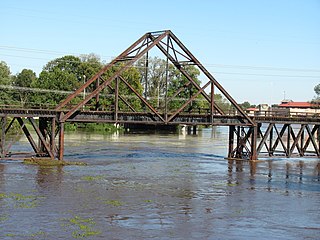
The Kansas City Southern Railroad Bridge (Cross Bayou), in downtown Shreveport, Louisiana, is an "A" Truss bridge erected in its current location in 1926 and abandoned in the 1980s. Due to its national significance to the progress of American bridge design, and its rarity as one of only two known surviving examples, the structure was designated a National Historic Place in 1995.
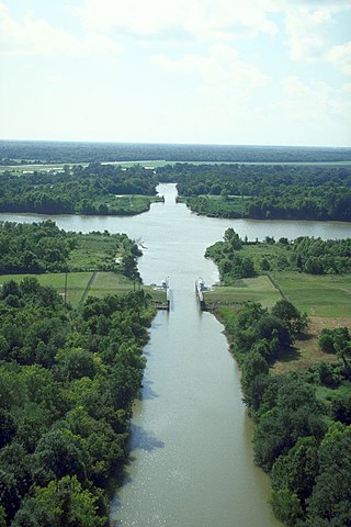
The Sherburne Complex is a joint land management venture of the U.S. Fish and Wildlife Service, the Louisiana Department of Wildlife and Fisheries (LDWF), and the U.S. Army Corps of Engineers that began in 1983. The area consists of 44,000 acres (180 km2), and is managed by the Louisiana Department of Wildlife and Fisheries. The complex is located in the Morganza Flood way system of the Atchafalaya Basin about 30 miles (48 km) west of Baton Rouge, Louisiana and actually extends a little south of the I-10 Atchafalaya Basin Bridge at Whiskey Bay, Louisiana. The bridge crosses the Whiskey Bay Pilot Channel. Located on the graveled LA 975, the west boundary is on the east side of the Atchafalaya River with the east boundary being the East Protection Levee. The complex stretches just north of old highway 190, and a short distance to the south of I-10. The nearest town is Krotz Springs to the north off US 190.
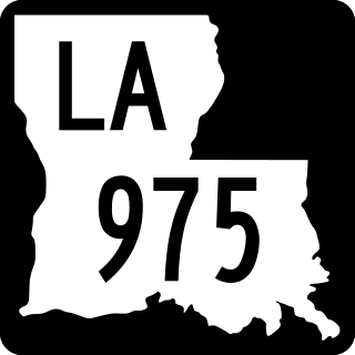
Louisiana Highway 975 (LA 975) is a gravel state highway in central Louisiana. It runs north–south for 18.4 miles (29.6 km). The southern terminus is at Whiskey Bay in Iberville Parish, and the northern terminus is east of Krotz Springs at a junction with U.S. Route 190 (US 190) and the north, south LA 973, in Pointe Coupee Parish. The entire route traverses the Sherburne Complex WMA, which is a combined Sherburne WMA, Atchafalaya National Wildlife Refuge, and Bayou Des Ourse, managed by the Louisiana Department of Wildlife and Fisheries. The road runs between the Atchafalaya River and Whiskey Bay Pilot Channel on the west and the East Protection Levee on the east.
Atchafalaya National Heritage Area is a federally designated National Heritage Area encompassing parts of fourteen parishes along the Atchafalaya River in the U.S. State of Louisiana. The heritage area extends the length of the Atchafalaya Basin from the area of Ferriday in the north to the river's mouth beyond Morgan City. The National Heritage Area is divided into four regions: Upper, Between 2 Rivers, Bayou Teche Corridor and the Coastal Zone. The designation provides a framework for the promotion and interpretation of the area's cultural and historic character, and the preservation of the natural and built environment. The heritage area designation recognizes the area's unique environment and culture, and its contributions to music, English and French language, literature, and cuisine.

Louisiana Highway 96 (LA 96) is a state highway located in southern Louisiana. It runs 19.54 miles (31.45 km) in an east–west direction from LA 182 in Broussard to LA 352 east of Catahoula.

Louisiana Highway 114 (LA 114) is a state highway located in Avoyelles Parish, Louisiana. It runs 20.86 miles (33.57 km) in an east–west direction from LA 1 east of Echo to a second junction with LA 1 and LA 451 east of Moreauville.
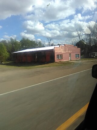
Big Bend is an unincorporated community in Avoyelles Parish, Louisiana, United States.

The McKee Street Bridge carries McKee Street across Buffalo Bayou in Houston, Texas. Built in 1932, the three-span reinforced concrete girder bridge connects the Second and Fifth Ward areas, northeast of downtown Houston. The bridge was listed on the National Register of Historic Places on September 3, 2002.

The Bordelonville Floodgate, in Avoyelles Parish, Louisiana near Bordelonville, Louisiana, was built during 1929 to 1931. It was listed on the National Register of Historic Places in 1991.

