
The Lake District, also known as the Lakes or Lakeland, is a mountainous region in North West England. A popular holiday destination, it is famous for its lakes, forests and mountains, and its associations with William Wordsworth and other Lake Poets and also with Beatrix Potter and John Ruskin. The Lake District National Park was established in 1951 and covers an area of 2,362 square kilometres. It was designated a UNESCO World Heritage Site in 2017.

The Old Man of Coniston is a fell in the Furness Fells in the Cumbria, English Lake District and was the highest point of Lancashire until local government reorganisation in 1974. It is at least 2,632.61 feet (802.42 m) high, and lies to the west of the village of Coniston and the lake, Coniston Water. The fell is sometimes known by the alternative name of Coniston Old Man, or simply The Old Man. The mountain is popular with tourists and fell-walkers with a number of well-marked paths to the summit. The mountain has also seen extensive copper and slate mining activity for eight hundred years and the remains of abandoned mines and spoil tips are a significant feature of the north-east slopes. There are also several flocks of sheep that are grazed on the mountain.

The Duddon Valley is a valley in the Lake District National Park in Cumbria, England. The River Duddon flows through the valley, rising in the mountains between Eskdale and Langdale, before flowing into the Irish Sea near Broughton in Furness. In its lower reaches it is bounded by the Furness Fells and Harter Fell.

The Duddon is a river of north-west England. It rises at a point 1,289 feet (393 m) above sea level near the Three Shire Stone at the highest point of Wrynose Pass. The river descends to the sea over a course of about 15 miles (24 km) before entering the Irish Sea at the Duddon Sands. In total, from source to the westernmost part of Duddon Sands, its length is 43 kilometres (27 mi). For its entire length the Duddon forms the boundary between the historic counties of Lancashire and Cumberland and since local government re-organisation in 1974 the Duddon has been in the ceremonial county of Cumbria.
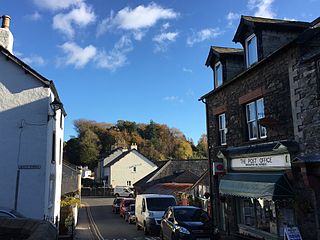
Broughton in Furness is a small market town in the civil parish of Broughton West in the South Lakeland district of Cumbria, England. It had a population of 529 at the 2011 Census. It is located on the south western boundary of England's Lake District National Park in the Furness region of Cumbria, which was originally part of Lancashire before 1974.

The Furness Fells are a multitude of hills and mountains in the Furness region of Cumbria, England. Historically part of Lancashire, the Furness Fells or High Furness is the name given to the upland part of Furness, that is, that part of Furness lying north of the line between Ulverston and Ireleth. The hills lie largely within the English Lake District.

Ulpha is a small village and civil parish in the Duddon Valley in the Lake District National Park in Cumbria, England. Historically in Cumberland, it forms part of the borough of Copeland. At Ulpha a road leaves the Duddon Valley to cross Birker Fell to the valley of Eskdale. In the 2001 census the parish had a population of 159, reducing at the 2011 Census to 128.

Dow Crag is a fell in the English Lake District near Coniston, Cumbria. The eastern face is one of the many rock faces in the Lake District used for rock climbing.

Stickle Pike is an outlying fell located in the southern Lake District near the small town of Broughton-in-Furness, with the summit situated between the lower Duddon Valley and the quiet smaller valley of Dunnerdale. Despite its low altitude the sharp, conical summit is prominent in views from the Broughton and high Furness areas. As with many of the Dunnerdale and Coniston fells, there are reminders of the area's former mining past in the form of many spoil heaps, disused levels and shafts. The fell is also notable for its wide-ranging views despite its low altitude, especially to the Scafells to the north and the sands of the Duddon Estuary to the south. A "stickle" is a hill with a prominent rocky top.

Grey Friar is a fell in the English Lake District, it is one of the Coniston Fells and is situated 13 kilometres west-south-west of Ambleside. It reaches a height of 770 metres and stands to the north west of the other Coniston Fells, a little off the beaten track and tends to be the least visited of the group. It is quite a large fell and forms the eastern wall of the Duddon Valley for several kilometres, in fact all drainage from Grey Friar goes to the Duddon Valley and not to Coniston Water.
Walna Scar is a hill in the English Lake District, lying just south of a pass of the same name in the Coniston Hills. Its summit at 2,035 feet (620 m) is only slightly higher than the pass.

Swirl How is a fell in the English Lake District. It stands between Coniston and the Duddon Valley in the southern part of the District. It rivals the Old Man of Coniston as the highest point within the traditional County Palatine of Lancashire.
Brim Fell is a fell in the English Lake District. It stands to the west of Coniston village in the southern part of the District.

Seathwaite is a small hamlet in Borrowdale valley in the Lake District of Cumbria, North West England. It is located 8 miles (13 km) southwest of Keswick at the end of a minor road that heads southwest from the hamlet of Seatoller, which is where the B5289 road begins its steep climb up the pass to Honister Hause on the boundary between Borrowdale civil parish and Buttermere civil parish.
There are four localities within the county of Cumbria in North West England named Seathwaite:

Dunnerdale-with-Seathwaite is a civil parish in the South Lakeland district of the English county of Cumbria. It includes the village of Seathwaite and the hamlets of Cockley Beck, Hall Dunnerdale and Hoses, and is located 6.2 miles (10.0 km) north of Broughton in Furness, 34.0 miles (54.7 km) west of Kendal and 57.3 miles (92.2 km) south of Carlisle. In the 2001 census the parish had a population of 129, decreasing at the 2011 census to 119.

Holy Trinity Church is in the village of Seathwaite, Cumbria, England. It is an active Anglican parish church in the deanery of Furness, the archdeaconry of Westmorland and Furness, and the diocese of Carlisle. Its benefice is united with those of four other local parishes. The church is recorded in the National Heritage List for England as a designated Grade II listed building.
Robert Walker (1709–1802), called Wonderful Walker, was an unassuming Church of England priest in Dunnerdale, now in Cumbria. William and Dorothy Wordsworth became interested in the local stories about him, around 1804; William mentioned Walker in The Excursion, and later in one of his sonnets.
Dunnerdale-with-Seathwaite is a civil parish in the South Lakeland District of Cumbria, England. It contains 18 listed buildings that are recorded in the National Heritage List for England. All the listed buildings are designated at Grade II, the lowest of the three grades, which is applied to "buildings of national importance and special interest". The parish is in the Lake District National Park, and is sparsely populated. It contains the settlements of Seathwaite, part of Ulpha, and Broughton Mills. The listed buildings include farmhouses, farm buildings, houses, bridges, potash kilns, a burial ground, a church, and a boundary stone.

Birks Bridge is a traditional stone-built bridge over the River Duddon in the English Lake District, in Dunnerdale-with-Seathwaite, Cumbria, standing at Grid Reference SD239995.


