Related Research Articles

The Modoc Rock Shelter is a rock shelter or overhang located beneath the sandstone bluffs that form the eastern border of the Mississippi River floodplain at which Native American peoples lived for thousands of years. This site is significant for its archaeological evidence of thousands of years of human habitation during the Archaic period in the Eastern United States. It is located on the northeastern side of County Road 7 southeast of Prairie du Rocher in Randolph County, Illinois, United States. It was declared a National Historic Landmark in 1961.
Hester Site is a major prehistoric archaeological site in Monroe County, Mississippi. It is a multicomponent site whose major occupation took place during the Archaic period with artifacts dating from 9000-8000 BCE, and other occupations during the Woodland and Mississippian periods. The site is one of the largest Archaic sites in the southeastern United States, and its well-stratified nature was critical in providing for accurate relative dating of finds at other sites throughout the region. The site was declared a National Historic Landmark in 2001.

The Onion Portage Archeological District encompasses a major archaeological site in Kobuk Valley National Park in northwestern Alaska. The site is a deeply stratified site, at which archaeologists have located nine complexes ranging dating from approximately 6500BC to AD1700. The site has been of critical benefit for the study of Arctic cultures, and is used to determine the cultural chronology of the region.

The Hardaway Site, designated by the Smithsonian trinomial 31ST4, is an archaeological site near Badin, North Carolina. A National Historic Landmark, this multi-layered site has seen major periods of occupation as far back as 10,000 years. Materials from this site were and are used to assist in dating materials from other sites in the eastern United States. The site was declared a National Historic Landmark in 1990.

The Horner Site, also known as the Creek Site and Horner's Corner Site, and designated by the Smithsonian trinomial 48PA29, is an important archaeological site near Cody, Wyoming. It is the type site for the Cody complex. It was declared a National Historic Landmark in 1961.
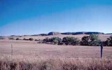
Signal Butte is a major prehistoric archaeological site in rural western Nebraska. Designated by the Smithsonian trinomial 25SF1, it was one of the first pre-contact Native American sites to be formally investigated in the central plains. The archaeological sites are located atop the eponymous butte west of Robidoux Pass and Gering, Nebraska. It was declared a National Historic Landmark in 1961. The site is not open to the public.

The Walker Gilmore Site, designated by the Smithsonian trinomial 22CC28, is a prehistoric archaeological site near Murray, Nebraska. First formally investigated in 1915, it is the type site for the Sterns Creek focus, the first Woodland period culture identified in Nebraska. It was designated a National Historic Landmark in 1964.
The Cape Site, designated Site 36.27 by the Maine Archaeological Survey, is a prehistoric archaeological site in West Leeds, Maine. Finds at the well-stratified waterfront site include ceramic fragments, stone tools, and remains of habitation dating as far as 6000 BCE. The site was listed on the National Register of Historic Places in 1992.

Cedar Swamp Archeological District is a prehistoric and historic archaeologically sensitive area in eastern Westborough, Massachusetts, and extending into the northwest corner of Hopkinton. Cedar Swamp is an area of more than 2,600 acres (1,100 ha) of wetlands that include the headwaters area of the Sudbury River. Archeological surveys of the environmentally sensitive and critical area have identified many Native American sites of interest. It is believed that Native Americans prized wood from the cedar trees that grew in the area. The archeological district, which encompasses much of the Cedar Swamp area, was added to the National Register of Historic Places in 1988.

The Sebec River is a tributary of the Piscataquis River in Piscataquis County, Maine. From the outflow of Sebec Lake in Sebec, the river runs 10.0 miles (16.1 km) east and southeast to its confluence with the Piscataquis in Milo.

Mummy Cave is a rock shelter and archeological site in Park County, Wyoming, United States, near the eastern entrance to Yellowstone National Park. The site is adjacent to the concurrent U.S. Routes 14/16/20, on the left bank of the North Fork of the Shoshone River at an altitude of 6,310 feet (1,920 m) in Shoshone National Forest.
The Memorial Park Site is an archaeological site located near the confluence of Bald Eagle Creek and the West Branch Susquehanna River in Lock Haven in the U.S. state of Pennsylvania. Research projects conducted at the site since 1979 have found prehistoric cultural deposits that collectively span 8,000 years.
The Rumford Archaeological Sites are a collection of prehistoric Native American sites in the vicinity of the Androscoggin River near Rumford, Maine. These six sites provide a window of observation into the movements and practices of Native Americans from c. 7,000 BCE to the Late Woodland period and contact with Europeans. These sites are the subject of three separate listings on the National Register of Historic Places in 1972: the Rumford Falls I-IV Sites, the Rumford V Site, and the Town of Rumford Site. The locations of these sensitive sites are not generally publicized.

Ntolonapemk, also known as the Eastern Surplus Company Superfund Site and Maine State Survey No. 96.02, is a prehistoric archaeological site in Meddybemps, a small town in Washington County, Maine. Located near the outlet of Meddybemps Lake, it is one of the only major inland prehistoric habitation sites in the county, with evidence of more than 8,000 years of use. The site was listed on the National Register of Historic Places in 2001.

The Caratunk Falls Archeological District is a complex of prehistoric and historic archaeological sites in the Solon, Maine area. First identified in the 1960s as archaeologically significant, the site was mapped by state archaeologists in the early 1980s. At that time it was the single largest complex of archaeological significance in interior Maine, encompassing a period of human activity from the Archaic to the European contact period. The 16-acre (6.5 ha) area was listed on the National Register of Historic Places in 1986.
The Hedden Site, designated Site 4.10 by the Maine Archaeological Survey, is a prehistoric archaeological site in Kennebunk, Maine. The site has been radiocarbon dated to c. 8550 BCE, and is a rare example in the state of a completely undisturbed (unplowed), stratified site. The site was listed on the National Register of Historic Places in 1991.
The Brockway Site, designated Site 90.3 by the Maine Archaeological Survey, is a prehistoric archaeological site in Milo, Maine. Long known to local amateur archaeologists, the site was formally tested in 1986, yielding evidence of a well-stratified site containing thousands of artifacts dating as far back as c. 2000 BCE. These types of sites are rare in the interior of Maine. The site was listed on the National Register of Historic Places in 1987.
Gut Island is a small 2-acre (0.81 ha) island in the Penobscot River, near Old Town and Milford in central Maine. The island, owned by the Penobscot Indian Nation, is archaeologically important, and has been designated Site 74.91 by the Maine Archaeological Survey. It was listed on the National Register of Historic Places in 1994 for its archaeological significance, which includes well-stratified evidence of human habitation dating back thousands of years.
The Eddington Bend Site, designated Site 74-8 by the Maine Archaeological Survey, is a prehistoric archaeological site in Eddington, Maine. Located near the banks of the Penobscot River, the site includes both evidence of habitation, and of funerary remains. The stratified site has dated elements as old as 3,000 BCE, and undated finds that are probably older. The site was listed on the National Register of Historic Places in 1988.
The King Coulee Site is a prehistoric Native American archaeological site in Pepin Township, Minnesota, United States. It was listed on the National Register of Historic Places in 1994 for having state-level significance in the theme of archaeology. It was nominated for being a largely undisturbed occupation site with intact stratigraphy and numerous biofacts stretching from the late Archaic period to the Oneota period. This timeframe spans roughly from 3,500 to 500 years ago. The site yielded the oldest known evidence of domesticated plants in Minnesota: seeds dated to 2,500 years ago from the squash Cucurbita pepo.
References
- 1 2 "National Register Information System". National Register of Historic Places . National Park Service. July 9, 2010.
- 1 2 3 Petersen, James; et al. (Fall 1986). "The Piscataquis Archaeological Project: A Late Pleistocene and Holocene Occupational Sequence in Northern New England". Archaeology of Eastern North America (Vol. 14): 1–18. JSTOR 40914263.
| Topics | |
|---|---|
| Lists by state |
|
| Lists by insular areas | |
| Lists by associated state | |
| Other areas | |
| Related | |