Dupont Circle is a historic roundabout park and neighborhood of Washington, D.C., located in Northwest D.C. The Dupont Circle neighborhood is bounded approximately by 16th Street NW to the east, 22nd Street NW to the west, M Street NW to the south, and Florida Avenue NW to the north. Much of the neighborhood is listed on the National Register of Historic Places. However, the local government Advisory Neighborhood Commission and the Dupont Circle Historic District have slightly different boundaries.

Henry Highland Garnet was an American abolitionist, minister, educator, orator, and diplomat. Having escaped as a child from slavery in Maryland with his family, he grew up in New York City. He was educated at the African Free School and other institutions, and became an advocate of militant abolitionism. He became a minister and based his drive for abolitionism in religion.

The National Building Museum is a museum of architecture, design, engineering, construction, and urban planning in Northwest Washington, D.C., U.S. It was created by an act of Congress in 1980, and is a private non-profit institution. Located at 401 F Street NW, it is adjacent to the National Law Enforcement Officers Memorial and the Judiciary Square Metro station. The museum hosts various temporary exhibits in galleries around the spacious Great Hall.

Columbia Heights is a neighborhood in Washington, D.C., located in Northwest D.C. Bounded by 16th Street NW, W Street NW, Florida Avenue NW, Barry Place NW, Sherman Avenue NW, Spring Road NW, and New Hampshire Avenue NW. neighborhood is an important retail hub for the area, as home to DC USA mall and to numerous other restaurants and stores, primarily along the highly commercialized 14th Street. Columbia Heights is home to numerous historical landmarks, including Meridian Hill Park, National Baptist Memorial Church, All Souls Church, along with a number of embassy buildings.

Logan Circle is a historic roundabout park and neighborhood of Washington, D.C., located in Northwest D.C. The majority of Logan Circle is primarily residential, except for the highly-commercialized 14th Street corridor that passes through the western part of the neighborhood. In the 21st century, Logan Circle has been the focus of urban redevelopment and become one of Washington's most expensive neighborhoods. Today, Logan Circle is also one of D.C.'s most prominent gay neighborhoods.

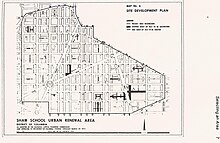
Shaw is a neighborhood of Washington, D.C., located in the Northwest quadrant. Shaw is a major entertainment and retail hub, and much of the neighborhood is designated as a historic district, including the smaller Blagden Alley-Naylor Court Historic District. Shaw and the U Street Corridor have historically have been the city's hub for African-American social, cultural, and economic life.

LeDroit Park is a neighborhood in Washington, D.C. located immediately southeast of Howard University. Its borders include Florida Avenue NW, Bryant Street NW, Georgia Avenue NW, and 2nd Street NW .LeDroit Park is known for its history and 19th century protected architecture. The community's diversity entices new residents to the community, as well as its close proximity to the Shaw–Howard University Metro station and many dining options.

The U Street Corridor or Greater U Street, sometimes known as Cardozo/Shaw, is a neighborhood in Washington, D.C., located in Northwest D.C. Centered along U Street, the neighborhood is one of Washington's most popular nightlife and entertainment districts, as well as one of the most significant African American heritage districts in the country.

Truxton Circle, sometimes known as East Shaw, is a neighborhood of Washington, D.C., located in Northwest D.C.

The Immaculata Seminary Historic District, commonly known as Tenley Campus, is an 8.2-acre (3.3 ha) parcel of land, located off of Tenley Circle in the Northwest Washington, D.C. neighborhood of Tenleytown. The site of Dunblane, an early to mid-nineteenth-century Federal/Greek Revival-style manor house, it was once part of a large country estate on the outskirts of the capital city, owned by a succession of prominent Georgetown residents. From 1904 to 1906, the land was acquired by the Catholic Sisters of Providence of Saint Mary-of-the-Woods, who, for decades, operated all-girls primary, secondary, and postsecondary schools there under the Immaculata name, before being forced to shutter due to financial issues. Since 1986, it has been a satellite campus of American University, which purchased the site in part because of its proximity to Tenleytown station on the Red Line of the Washington Metro. It currently houses the school's Washington College of Law.

The Strivers' Section Historic District is a historic district located in the Dupont Circle neighborhood of Washington, D.C. Strivers' Section was historically an enclave of upper-middle-class African Americans, often community leaders, in the late 19th and early 20th centuries. It takes its name from a turn-of-the-20th-century writer who described the district as "the Striver's section, a community of Negro aristocracy." The name echoes that of Strivers' Row in Harlem, a New York City historic neighborhood of black professionals. The district is roughly bounded by Swann Street and the Dupont Circle Historic District on the south, Florida Avenue and the Washington Heights Historic District on the north and west, and the Sixteenth Street Historic District on the east.

Friendship Armstrong Academy is a public charter school located in the Truxton Circle neighborhood of Washington, D.C. Historically a black school, it is housed in the former Armstrong Manual Training School, also known as the Samuel Chapman Armstrong Technical High School.

The Reno School is a historic school building located at 4820 Howard Street NW, completed in 1903 to serve the needs of the Reno community in Washington, D.C. Like all public schools in the District at the time, it was segregated and served African American students in the area west of Rock Creek Park and north of Georgetown. The school was closed in 1950 after the Reno community was evicted to create Fort Reno Park and the adjacent Alice Deal Middle School.

M Street High School, also known as Dunbar High School, is a historic former school building located in the Northwest Quadrant of Washington, D.C. It has been listed on the District of Columbia Inventory of Historic Sites since 1978 and it was listed on the National Register of Historic Places in 1986. The building escaped demolition with community support and the efforts of preservationists and is now a community center.

The Thaddeus Stevens School is a historic African American school building located at 1050 21st Street, N.W., in the West End neighborhood of Washington, D.C. It houses classrooms for the nearby and also as an early childhood center.

John Mercer Langston School is a historic structure located in the Truxton Circle neighborhood in Washington, D.C. The two-story brick building was designed by Appleton P. Clark, Jr. The structure was completed in 1902. It was listed on the National Register of Historic Places in 2013.

John Fox Slater Elementary School is an historic structure located in the Truxton Circle neighborhood in Washington, D.C. The two-story brick building was designed by Edward Clark and completed in 1891. It was listed on the National Register of Historic Places in 2013.

Mount Vernon Triangle is a neighborhood and community improvement district in the northwest quadrant of Washington, D.C. The neighborhood is located adjacent to Mount Vernon Square. Originally a working-class neighborhood established in the 19th century, present-day Mount Vernon Triangle experienced a decline in the mid-20th century as it transitioned from residential to commercial and industrial use.

Albert L. Harris was an American architect who worked primarily in Washington, D.C. He was born in Wales and emigrated to the United States as a young child. He worked for architectural firms in Chicago and Baltimore and then Washington, where he also obtained an architectural degree from George Washington University. He was a part-time professor there while also working for the US Navy and then the city of Washington where he served as the city's Municipal Architect from 1921 until his death in 1933. A number of his works are listed on the National Register of Historic Places (NRHP).