
Lakeview is one of the 77 community areas of Chicago, Illinois. Lakeview is located on the city's North Side and is bordered by West Diversey Parkway on the south, West Irving Park Road on the north, North Ravenswood Avenue on the west, and the shore of Lake Michigan on the east. The Uptown community area is to Lakeview's north, Lincoln Square to its northwest, North Center to its west, and Lincoln Park to its south. The 2020 population of Lakeview was 103,050 residents, making it the second-largest Chicago community area by population.

Edgewater is a lakefront community area on the North Side of the city of Chicago, Illinois six miles north of the Loop. The most recently established of the city's 77 official community areas, Edgewater is bounded by Foster Avenue on the south, Devon Avenue on the north, Ravenswood Avenue on the west, and Lake Michigan on the east. Edgewater contains several beaches for residents to enjoy. Chicago's largest park, Lincoln Park, stretches south from Edgewater for seven miles along the waterfront, almost to downtown. Until 1980, Edgewater was part of Uptown, and historically it constituted the northeastern corner of Lake View Township, an independent suburb annexed by the city of Chicago in 1889. Today, Uptown is to Edgewater's south, Lincoln Square to its west, West Ridge to its northwest and Rogers Park to its north.
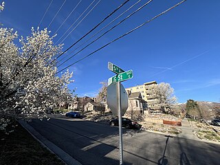
The Avenues is an affluent neighborhood in Salt Lake City, Utah. It is named after the perfectly gridlike, closely laid out roads called Avenues and Streets. First surveyed in the 1850s, the Avenues became Salt Lake City's first neighborhood. Today, the Avenues neighborhood is generally considered younger, more progressive, and somewhat "artsy" when compared to other neighborhoods. Many young professionals choose to live there due to the culture and easy commute to downtown.. It is also one of the most important strongholds of the Utah Democratic Party.

Uptown is one of Chicago's 77 community areas. Uptown's boundaries are Foster Avenue to the north; Lake Michigan to the east; Montrose Avenue, and Irving Park Road to the south; Ravenswood Avenue, and Clark Street to the west. To the north is Edgewater, to the west is Lincoln Square, and to the south is Lakeview. Near the lake are some of the northern reaches of Lincoln Park, including Montrose Beach and multiple nature reserves. The area has a mix of commercial and residential development, and includes a well-established entertainment district of clubs and concert venues, and was a center for early film making. Truman College, a two-year city college, is located here, and the area's southwest corner includes the historic 19th century Graceland Cemetery.

The Near South Side is a community area of Chicago, Illinois, United States, just south of the downtown central business district, the Loop. The Near South Side's boundaries are as follows: North—Roosevelt Road ; South—26th Street; West—Chicago River between Roosevelt and 18th Street, Clark Street between 18th Street and Cermak Road, Federal between Cermak Road and the Stevenson Expressway just south of 25th Street, and Clark Street again between the Stevenson and 26th Street; and East—Lake Michigan.
The Bryn Mawr Historic District is on the lakefront of the Edgewater neighborhood of far-north Chicago, Illinois. It extends along Bryn Mawr Avenue between Broadway and Sheridan Road. Its most prominent features are the Belle Shore Apartment Hotel, Bryn Mawr Apartment Hotel, Edgewater Beach Apartments, Edgewater Presbyterian Church, Manor House, and the northernmost area of Lincoln Park.

Sunnyside Gardens is a community within Sunnyside, a neighborhood in the New York City borough of Queens. The area was the first development in the United States patterned after the ideas of the garden city movement initiated in England in the first decades of the twentieth century by Ebenezer Howard and Raymond Unwin, specifically Hampstead Garden Suburb and Letchworth Garden City.

Lyon Village is a neighborhood and urban village in Arlington County, Virginia, along Langston Boulevard. It adjoins Arlington County's government center, and is approximately one mile west of Rosslyn and less than a mile north of Clarendon, of which it is sometimes considered a sub-neighborhood, as is Cherrydale, the mostly residential district immediately west of Lyon Village.

Lafayette Park is a neighborhood located east of Downtown Detroit. It contains a residential area of some 4,900 people and covers 0.37 sq mi.

Cermak Road, also known as 22nd Street, is a 19-mile, major east–west street on Chicago's near south and west sides and the city's western suburbs. In Chicago's street numbering system, Cermak is 2200 south, or twenty-two blocks south of the baseline of Madison Street. Normally, one mile comprises eight Chicago blocks, but the arterial streets Roosevelt Road, formerly named Twelfth Street and at 1200 South, and Cermak Road were platted before the eight-blocks-per-mile plan was implemented. Roosevelt Road is one mile south of Madison Avenue and there are twelve blocks within that mile. Cermak Road is two miles south of Madison Avenue and there are ten blocks within the mile between Roosevelt and Cermak Roads.

The Emil Bach House is a Prairie style house in the Rogers Park neighborhood of Chicago, Illinois, United States that was designed by architect Frank Lloyd Wright. The house was built in 1915 for an admirer of Wright's work, Emil Bach, the co-owner of the Bach Brick Company. The house is representative of Wright's late Prairie style and is an expression of his creativity from a period just before his work shifted stylistic focus. The Bach House was declared a Chicago Landmark on September 28, 1977, and was added to the U.S. National Register of Historic Places on January 23, 1979.

Downtown Omaha is the central business, government and social core of the Omaha–Council Bluffs metropolitan area, U.S. state of Nebraska. The boundaries are Omaha's 20th Street on the west to the Missouri River on the east and the centerline of Leavenworth Street on the south to the centerline of Chicago Street on the north, also including the CHI Health Center Omaha. Downtown sits on the Missouri River, with commanding views from the tallest skyscrapers.

The University–Cultural Center MRA is a pair of multiple property submissions to the National Register of Historic Places which were approved on April 29 and May 1, 1986. The structures included are all located in Midtown, near Woodward Avenue and Wayne State University in Detroit, Michigan. The two submissions are designated the University–Cultural Center MRA Phase I, containing five properties, and the University–Cultural Center MRA Phase II, containing three properties.

Rosenwald Court Apartments is a large apartment building located in the Bronzeville neighborhood of the South Side of Chicago, Illinois. It is located at East 47th Street and South Michigan Avenue, just one block east of the former Chicago Housing Authority's Robert Taylor Homes site. In total, the building is made up of 421 apartments, a large landscaped courtyard, and retail space at street level. It was originally built as non-governmental subsidized housing and is considered to be among the earliest mixed-use housing developments.
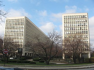
The University Apartments, also known as the University Park Condominiums, are a pair of ten-story towers in Chicago, Illinois designed by I. M. Pei and Araldo Cossutta. The project was part of a city initiative to revitalize the residential development in Hyde Park just north of the University of Chicago. Within the Hyde Park neighborhood, they are colloquially known as "Monoxide Island."
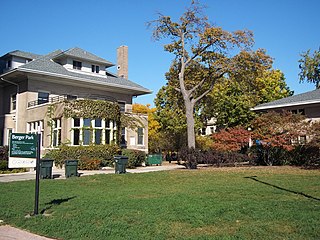
Berger Park, officially Park #1255 of the Chicago Park District, is a small recreational area bordering Lake Michigan in the Edgewater neighborhood of North Side, Chicago, Illinois. The park features the historic Downey House and Samuel H. Gunder houses.

The Sheridan-Kalorama Historic District is a neighborhood and historic district located in the northwest quadrant of Washington, D.C. The boundaries of the historic district include Rock Creek Park to the north and west, P Street to the south, and 22nd Street and Florida Avenue to the east. On the southwestern edge of the neighborhood is a stretch of Embassy Row on Massachusetts Avenue. The other neighborhood and historic district that lies to the east of Sheridan-Kalorama is Kalorama Triangle Historic District. The two neighborhoods are divided by Connecticut Avenue. For many years both neighborhoods were geographically connected before the stretch of Connecticut Avenue was installed toward the Taft Bridge. Oftentimes, both neighborhoods are simply called "Kalorama" or "Kalorama Heights".

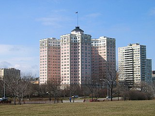
The Building at 5510 North Sheridan is a historic apartment building at 5510 N. Sheridan Road in the Edgewater neighborhood of Chicago, Illinois. Built in 1927, the seventeen-story building was originally marketed as luxury apartment housing with views of Lake Michigan. Luxury apartments became popular in the 1920s in Chicago, especially on lakefront plots where developers sought to maximize the land's value; to convince affluent Chicagoans to live in a smaller space, new apartments were frequently compared to Parisian apartments, which had become a status symbol in France in the nineteenth century. Architects Quinn & Christiansen designed the French Renaissance Revival building; the French-inspired architecture was used to market the apartments as Parisian. The building's design features a brick exterior with decorative limestone, quoins around the front entrances, and a cornice below a recessed mansard roof.

The Wrightwood Bungalow Historic District is a residential historic district encompassing the 4600 and 4700 blocks of Wrightwood Avenue in the Belmont Cragin neighborhood of Chicago, Illinois. The district includes 58 houses built between 1916 and 1926, 55 of which are Chicago bungalows. As homeownership became more accessible in early twentieth century Chicago, the bungalow became popular as an affordable home design, and tens of thousands of the houses were built throughout Chicago. Like many of Chicago's bungalow-heavy neighborhoods, both the district and the Belmont Cragin neighborhood in general saw little residential development before the bungalow boom; however, the area was much more industrial than most similar neighborhoods. While several developers built bungalows in the district, the Stolzner Construction Company built over half of them, including every bungalow on the 4600 block. The company's architect, Joseph Klafter, differentiated the bungalows by changing details such as their color, entrance position, and dormer design.
Roy F. France (1888-1972) was the American architect who is credited with creating the Miami Beach, Florida skyline.


