Sherridon

Last updated

Sherridon
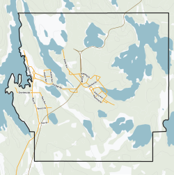
713 Sherridon, Manitoba.svg
Community boundaries
Canada Manitoba location map 2.svg
Red pog.svg
Sherridon
Location of Sherridon
Coordinates: 55°7′26″N101°5′12″W / 55.12389°N 101.08667°W / 55.12389; -101.08667
CountryCanada
Province Manitoba
Region Northern
Census Division No. 21
Government
  MayorNick Benyk
  Governing BodySherridon Community Council
   MP Niki Ashton
   MLA Tom Lindsey
Population
  Total80
  Density4.1/km2 (11/sq mi)
Time zone UTC−06:00 (CST)
  Summer (DST) UTC−05:00 (CDT)
Postal Code
R0B 1L0
Area code(s) 204, 431
NTS Map063N03
GNBC CodeGAZAC

Sherridon, Manitoba, is an unincorporated community in northern Manitoba, Canada.

Contents

History

Sherridon originated as the service centre for the nearby Sherritt Gordon Mine. The mine closed in 1952, resulting in the equipment and many of the workers and families relocating to Lynn Lake. In 1949 the first house from Sherridon was sleighed to Lynn Lake as a test run over the 160 mi (260 km) of cat train trails. Over the next three years, 208 buildings were moved to Lynn Lake from Sherridon. Houses, stores, banks and churches were loaded on sleighs and pulled by caterpillar tractors over the ice and snow to Lynn Lake.

The historic four-storey Hotel Cambrian, one of the only early 20th century buildings in the community not moved to Lynn Lake, was destroyed by fire on June 2, 2012. At the time of the fire the hotel was unoccupied, in a state of disrepair, and had been disconnected from electricity. The Royal Canadian Mounted Police consider the fire suspicious. [2]

A recent gold mine, operated by Pioneer Metals at Puffy Lake, closed in 1989.

Geography

The community is on the OmniTRAX rail line to Lynn Lake about 156 km (97 mi) north of The Pas. Pukatawagan Reserve is 72 km (45 mi) further north of Sherridon. A 78 km (48 mi) community-access gravelled road was constructed as part of the Puffy Lake Mine development, and the community is now connected to Provincial Trunk Highway 10 (PTH 10) between Cranberry Portage and Flin Flon.

Demographics

In the 2021 Census of Population conducted by Statistics Canada, Sherridon had a population of 56 living in 20 of its 31 total private dwellings, a change of

Related Research Articles

Lynn Lake is a town in the northwest region of Manitoba, Canada, approximately 1,071 km (665 mi) from Winnipeg. The town is the fourth-largest town in Manitoba in terms of land area. It is centred on the original urban community of Lynn Lake. The town was named after Lynn Smith, chief engineer of Sherritt Gordon Mines Ltd. There are many outfitters in the Lynn Lake area, offering services for most wilderness experiences, including sport fishing and bear and moose hunting.

Frank is an urban community in the Rocky Mountains within the Municipality of Crowsnest Pass in southwest Alberta, Canada. It was formerly incorporated as a village prior to 1979 when it amalgamated with four other municipalities to form Crowsnest Pass.

<span class="mw-page-title-main">Gillam, Manitoba</span> Town in Manitoba, Canada

Gillam is a town on the Nelson River in northern Manitoba, Canada. It is situated between Thompson and Churchill on the Hudson Bay Railway line.

Snow Lake is a town in Manitoba, Canada, located 685 km north of Winnipeg at the end of Provincial Road 392. The main industry is, and always has been, mining; currently with one mine producing Zinc, and another lithium. The official Town of Snow Lake is a very large, overwhelmingly rural area that is centered about the urban community of Snow Lake, which lies very near its geographical center. The Town is as large in area as a typical rural municipality in the more southern parts of Manitoba.

Leaf Rapids is a town in northwest Manitoba, Canada. The town was developed as using an experimental model that emphasized modern convenience and luxury in a northern environment. The community is located approximately 1,000 km north of Winnipeg along the Churchill River. The original (urban) community of Leaf Rapids is on Manitoba Provincial Road 391, although most of the large official town created later lies east of this community. This town is as large as a typical Rural Municipality in the more southern parts of Manitoba.

<span class="mw-page-title-main">Norway House</span> Population centre in Manitoba, Canada

Norway House is a population centre of over 5,000 people, some 30 km (19 mi) north of Lake Winnipeg, on the bank of the eastern channel of Nelson River, in the province of Manitoba, Canada. The population centre shares the name Norway House with the northern community of Norway House and Norway House 17, a First Nation reserve of the Norway House Cree Nation. Thus, Norway House has both a Chief and a Mayor.

Brochet is an unincorporated community located in Northern Manitoba on the northern shore of Reindeer Lake near the Saskatchewan border; it is designated as a northern community.

<span class="mw-page-title-main">Cross Lake, Manitoba</span> Place in Manitoba, Canada

Cross Lake is a community in the Northern Region of the Canadian province of Manitoba, situated on the shores of the Nelson River where the river enters the namesake Cross Lake. An all-weather road, PR 374, connects the communities to PR 373 via the Kichi Sipi Bridge.

Warner is a village in Alberta, Canada. It is surrounded by the County of Warner No. 5, approximately 65 km (40 mi) south of Lethbridge. Warner is a farming community. Warner is situated at the intersection of Highway 4 and Highway 36, about 38 km north of the Montana border and Interstate 15. Warner's nearest neighbours are the towns of Stirling and Milk River.

<span class="mw-page-title-main">Beaver Mines</span> Hamlet in Alberta, Canada

Beaver Mines is a hamlet in southern Alberta, Canada within the Municipal District of Pincher Creek No. 9. It is located in the foothills of the Canadian Rockies on Highway 507, approximately 19 km (12 mi) west of Pincher Creek.

Powerview-Pine Falls is a town in the Canadian province of Manitoba, with a population of 1,314 at the 2011 census, up 1.54% from 1,294 at the 2006 census and down 7.57% from 1,400 during the 2001 census.

<span class="mw-page-title-main">Somerset, Manitoba</span> Place in Manitoba, Canada

Somerset is an unincorporated community recognized as a local urban district in the Municipality of Lorne within the Canadian province of Manitoba that held village status prior to January 1, 2015.

<span class="mw-page-title-main">Wabowden</span> Place in Manitoba, Canada

Wabowden is a community in northern Manitoba. It is situated on Provincial Trunk Highway No. 6, which is the main route between Thompson and the provincial capital, Winnipeg.

<span class="mw-page-title-main">Cadomin</span> Hamlet in Alberta, Canada

Cadomin is a hamlet in the west-central Alberta, Canada within Yellowhead County. It is located along the McLeod River in the foothills of the Rocky Mountains, approximately 50 kilometres (31 mi) south of Hinton near the Bighorn Highway. It is served by a spur of the Canadian National Railway.

<span class="mw-page-title-main">Lundbreck</span> Hamlet in Alberta, Canada

Lundbreck is a hamlet in southern Alberta, Canada within the Municipal District of Pincher Creek No. 9. It is located on the south side of Highway 3, approximately 3 kilometres (1.9 mi) east of the southern terminus of Highway 22, 16 km (9.9 mi) east of the Municipality of Crowsnest Pass, 4 km (2.5 mi) west of the Village of Cowley and 16 km (9.9 mi) west of the Town of Pincher Creek. It has an elevation of 1,200 m (3,900 ft).

Collingwood Cove is a hamlet in Alberta, Canada within Strathcona County. It is located at the terminus of Highway 629, approximately 17 kilometres (11 mi) southeast of Sherwood Park.

<span class="mw-page-title-main">East Coulee, Alberta</span> Former hamlet in Alberta, Canada

East Coulee is a community within the Town of Drumheller, Alberta, Canada. It was previously a hamlet within the former Municipal District (MD) of Badlands No. 7 prior to the MD's amalgamation with the former City of Drumheller on January 1, 1998. It is also recognized as a designated place by Statistics Canada.

<span class="mw-page-title-main">Rosedale, Alberta</span> Former hamlet in Alberta, Canada

Rosedale is a community within the Town of Drumheller, Alberta, Canada. It was previously a hamlet within the former Municipal District (MD) of Badlands No. 7 prior to the MD's amalgamation with the former City of Drumheller on January 1, 1998. It is also recognized as a designated place by Statistics Canada.

Red Deer Lake is a community in the Canadian province of Manitoba. A designated place in Canadian census data, the community had a population of 25 in the Canada 2006 Census.

Laurier is an unincorporated urban community in the Rural Municipality of Ste. Rose, Manitoba, Canada. It is located on Highway 480, 3.2 km (2.0 mi) west of Highway 5, between the community of McCreary to the south and the community of Ste. Rose du Lac to the north.

References

  1. "Census Profile - Data table: Sherridon, NCM (Designated Place), Manitoba". Statistics Canada, 2011 Census of Population. September 7, 2012. Retrieved October 20, 2012.
  2. "Sherridon historic hotel fire under investigation". CBC News - Manitoba. June 3, 2012. Retrieved October 20, 2012.
  3. "Population and dwelling counts: Canada and designated places". Statistics Canada. February 9, 2022. Retrieved September 3, 2022.