Sheyenne, North Dakota

Last updated

Sheyenne, North Dakota
Copy of Sheyenne 4-Devils Run 003.jpg
Looking north on U.S. Route 281
Motto: 
Proud To Be A Small Town
ND Eddy County Sheyenne.svg
Location of Sheyenne, North Dakota
Coordinates: 47°49′38″N99°07′01″W / 47.82722°N 99.11694°W / 47.82722; -99.11694
CountryUnited States
State North Dakota
County Eddy
Founded1883
Government
   Mayor Richard Comer
Area
[1]
  Total0.15 sq mi (0.39 km2)
  Land0.15 sq mi (0.39 km2)
  Water0.00 sq mi (0.00 km2)
Elevation
[2]
1,476 ft (450 m)
Population
 (2020) [3]
  Total186
  Estimate 
(2022) [4]
183
  Density1,240.00/sq mi (479.22/km2)
Time zone UTC-6 (Central (CST))
  Summer (DST) UTC-5 (CDT)
ZIP code
58374
Area code 701
FIPS code 38-72580
GNIS feature ID1036262 [2]

Sheyenne is a city in Eddy County, North Dakota, United States. The population was 186 at the 2020 census. [3] Sheyenne was founded in 1883. A community center and the Log Cabin Museum are located on Main Street (U.S. Route 281). On the east end of town there is a park with campsites located on Warsing Dam. Sheyenne is also home to two Lutheran churches: Grace Lutheran and First Lutheran.

Contents

History

The name "Sheyenne" is derived from the nearby Sheyenne River which was named after the Cheyenne Indians. The first explorers in the area misspelled the name, thus changing the "C" to an "S". Herds of bison once roamed the prairies near the town of Sheyenne. The Sioux tribe were the final Native American tribe to move towards the area. The first white settlers came via the Northern Pacific Railroad Company. The earliest mention of the settlement came through the Grand Forks, North Dakota-based paper, Normadden. The Norwegian language paper mentioned the building of the section house in 1885 and the setting up of six tents in order to establish a townsite and a depot. The main track was laid on November 28, 1884. The railroad began operation to Sheyenne on August 6, 1885.

The main townsite of Sheyenne was obtained by Clarence E. Bennett in 1885, but later came under the jurisdiction of J. W. Richter, who dedicated the townsite in 1892. The first crops grown in the area were common vegetables and as much wheat that the land could take. The main source of meat was hunting on the abundant plains, and the other source was in the Sheyenne River. People streamed into the community from all parts of the United States and Europe. Most European settlers came from Scandinavia and Germany. Businesses flourished off railroad workers and farmers.

Fire of 1894

On December 7, 1894 at approximately 4:30 A.M., a fire began in the George Williams Livery Barn and spread to other businesses on Main Street. Williams' billiard room and soft drink shop were the next to be consumed. The blaze then spread to the Westerlund Hotel and the Hugh Peoples General Store. The post office also caught fire, but N.U. Hanson saved all the mail that was on-hand. The fire was determined to be incendiary in origin. George Williams closed his stables at 2:00 A.M. and locked the door. When firemen arrived at the scene, they realized that the door was open, and later it was determined that the fire began in the unused box stall. In the wake of the disaster, the merchants rebuilt and continued serving the Sheyenne area.

Sheyenne was home to C.G. Hayes, a farmer by trade who lived South of the townsite. Hayes became a soldier and was stationed at Fort Totten. He became a scout during the Indian Wars in the Northwest. After that, he served under the Seventh Cavalry banner, and was one of the messengers who sent for reinforcements after The Battle of the Little Bighorn. In 1897, Sheyenne began publishing its first newspaper, The Sheyenne Star.

The 1900s

Settlers and immigrants continued to swarm to the area as they came via boxcar and train. They also arrived by cars and wagons. Businesses in Sheyenne included numerous department stores, meat markets, livery stables, a depot, a blacksmith shop operated by Hans Stenberg, Odegaard's Shop, a feed mill, and land companies. Sheyenne had several elevators that stored different local goods. There was a Ford dealership, numerous service stations, numerous pharmacies, cafes, a hotel, a public bath, and a lumberyard. A cream station, an opera house, and a variety store also existed in Sheyenne at one time. Many banks have come and gone over the brief period of Sheyenne's existence, including the Farmers' State Bank.

Looking north on Highway 281 in Sheyenne Sheyenne 007.jpg
Looking north on Highway 281 in Sheyenne

Creamery Day Celebration 1913

The opening of the creamery in Sheyenne was the largest event in Sheyenne history in terms of turnout. The event was created to celebrate the opening of Sheyenne's creamery on June 28, 1913. Over 2000 people were present at the event. The festivities began with a parade that covered 22 blocks that included the Fort Totten Indian Band, the Boy Scouts, and numerous merchants' floats. The parade ended at the creamery, where everyone was served free ice cream and buttermilk. Over 1900 ice cream cones were served. The climax of the day was when Professor G.F. Martin of North Dakota Agricultural College, now North Dakota State University, spoke about the importance of dairy. A baseball game was then played between Sheyenne and New Rockford, and at 9:00 a grand ball was held at the opera house.

1914–present

The Sheyenne area progressed through World War I and the 1918 influenza epidemic. A shock to the area came in the 1930s with the Great Depression, when the main industry of the area, agriculture, was threatened severely. Poor crop prices influenced Sheyenne's economy and the WPA was crucial to the life of Sheyenne. It created a park on the south side of Sheyenne that is now owned by the VFW, it restored the town jail, and its workers built Warsing Dam on the outskirts of the city. In the 1940s numerous residents fought in World War II, and the Sheyenne Star ceased publication. In 1955, the second irrigation experimental farm in North Dakota was planned on the land of Bruce Larson, while a major concern of the late 1950s was the high nitrate condition in the wells of Sheyenne. The problem was solved by the Northern Pacific Railway Company donating their well to the City of Sheyenne. A major event in the 1960s was the opening of the Tastee-Freez, a fast food and ice cream restaurant, in the building previously occupied by the city's fire department. Community betterment was the highlight of the 1970s in Sheyenne, when projects such as street paving, tennis courts, townhouses, a museum, and main street revitalization were finished. In 1977 Sheyenne won the North Dakota Community Betterment Award for its work on its projects.

Sheyenne celebrated its 125th with a demo-derby, BBQ dinner, parade, school reunion, fireworks, and a children's theater production, put on by the S.T.A.R.S.

Geography

According to the United States Census Bureau, the city has a total area of 0.16 square miles (0.41 km2), all land. [5]

The city of Sheyenne and its vicinity is located in the distinct Drift Prairie region of North Dakota. The Drift Prairie region is characterized by rolling hills and many sloughs. The main body of water near Sheyenne is the Sheyenne River, but the man-made Warsing Dam is the main source of recreational activity near the city. The area is also in the Devil's Lake Basin region, home to Devil's Lake, the largest natural body of water in the state of North Dakota. South of the city lies the Laurentian Divide, which separates the watersheds of the Arctic Ocean and the Atlantic Ocean.

Climate

Sheyenne experiences an extreme Continental climate. It experiences wide temperature changes and four distinct seasons. Its location in the center of North America and the Upper Midwest gives it distinctive upper air patterns that vary dramatically from season to season.

According to the United States Census Bureau, the city has a total area of 0.2 square miles (0.52 km2), all land.

Demographics

Historical population
CensusPop.Note
1930 417
1940 4313.4%
1950 4698.8%
1960 423−9.8%
1970 362−14.4%
1980 307−15.2%
1990 272−11.4%
2000 31816.9%
2010 204−35.8%
2020 186−8.8%
2022 (est.)183 [4] −1.6%
U.S. Decennial Census [6]
2020 Census [3]
The Ostby Hall- Community Activities Ostby Hall.jpg
The Ostby Hall- Community Activities

2010 census

As of the census of 2010, there were 204 people, 103 households, and 51 families residing in the city. The population density was 1,275.0 inhabitants per square mile (492.3/km2). There were 147 housing units at an average density of 918.8 per square mile (354.8/km2). The racial makeup of the city was 81.4% White, 1.0% African American, 14.7% Native American, 0.5% from other races, and 2.5% from two or more races. Hispanic or Latino of any race were 1.0% of the population.

There were 103 households, of which 11.7% had children under the age of 18 living with them, 37.9% were married couples living together, 7.8% had a female householder with no husband present, 3.9% had a male householder with no wife present, and 50.5% were non-families. 41.7% of all households were made up of individuals, and 21.4% had someone living alone who was 65 years of age or older. The average household size was 1.98 and the average family size was 2.73.

The median age in the city was 54.3 years. 12.3% of residents were under the age of 18; 4.9% were between the ages of 18 and 24; 18.1% were from 25 to 44; 40.2% were from 45 to 64; and 24.5% were 65 years of age or older. The gender makeup of the city was 49.5% male and 50.5% female.

2000 census

As of the census of 2000, there were 318 people, 146 households, and 85 families residing in the city. The population density was 2,042.1 inhabitants per square mile (788.5/km2). There were 187 housing units at an average density of 1,200.9 per square mile (463.7/km2). The racial makeup of the city was 83.96% White, 12.26% Native American, and 3.77% from two or more races.

There were 146 households, out of which 26.7% had children under the age of 18 living with them, 50.0% were married couples living together, 6.2% had a female householder with no husband present, and 41.1% were non-families. 39.7% of all households were made up of individuals, and 26.0% had someone living alone who was 65 years of age or older. The average household size was 2.18 and the average family size was 2.94.

In the city, the population was spread out, with 23.9% under the age of 18, 7.2% from 18 to 24, 19.2% from 25 to 44, 25.5% from 45 to 64, and 24.2% who were 65 years of age or older. The median age was 45 years. For every 100 females, there were 80.7 males. For every 100 females age 18 and over, there were 80.6 males.

The median income for a household in the city was $22,969, and the median income for a family was $30,938. Males had a median income of $25,972 versus $24,583 for females. The per capita income for the city was $16,145. About 10.7% of families and 12.3% of the population were below the poverty line, including 20.3% of those under age 18 and 4.5% of those age 65 or over.

Sites of interest

The Log Cabin Museum on Main Street, built in 1867 Log Cabin Museum.jpg
The Log Cabin Museum on Main Street, built in 1867

Education

The old Sheyenne School, showing the first original (1908) building and additions from 1930 and 1962 Sheyenne School.jpg
The old Sheyenne School, showing the first original (1908) building and additions from 1930 and 1962

Before the first Sheyenne school was built, classes in 1886 were held in a sod house, but soon a wood-frame building was built west of the Sheyenne's railroad tracks. The first school in Sheyenne was moved to Richter Avenue, and when it became too small, it became the office for the Sheyenne Star newspaper. In 1897, a two-story schoolhouse was built, and the first floor could be used for school purposes only, whereas the second floor could be used for meetings and church services. In 1898, school was closed for two weeks due to an outbreak of scarlet fever and measles. In the first months of 1903, many pupils left the Sheyenne school to attend Scandinavian Studies in Greenfield Township. In April 1903, school was prohibited due to a smallpox outbreak. In 1908, a new school was built on the eastern side of Sheyenne and in 1930, an addition was made to the two-story brick building. In the late 1950s, it was decided to add on once again. While the project was in progress, the Ostby Hall and Grace Lutheran Church were used as overflow classrooms. In 1962, the project was completed. The Sheyenne High School lasted for 99 years until the spring of 2007, when it closed for its pupils. Today, most children living in and around Sheyenne attend school in nearby New Rockford because Sheyenne is part of the New Rockford-Sheyenne Public School.

Notable person

Related Research Articles

<span class="mw-page-title-main">Richland County, North Dakota</span> County in North Dakota, United States

Richland County is a county in the far southeast corner of the U.S. state of North Dakota. As of the 2020 census, the population was 16,529. Its county seat is Wahpeton.

<span class="mw-page-title-main">Ransom County, North Dakota</span> County in North Dakota, United States

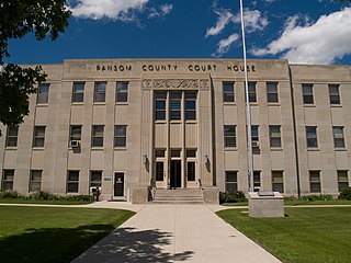
Ransom County is a county in the U.S. state of North Dakota. As of the 2020 census, the population was 5,703. Its county seat is Lisbon.

<span class="mw-page-title-main">Eddy County, North Dakota</span> County in North Dakota, United States

Eddy County is a county in the U.S. state of North Dakota. As of the 2020 census, the population was 2,347. Its county seat is New Rockford.

<span class="mw-page-title-main">Benson County, North Dakota</span> County in North Dakota, United States

Benson County is a county in the U.S. state of North Dakota. As of the 2020 census, the population was 5,964. Its county seat is Minnewaukan. The county was created on March 9, 1883 by the Dakota Territory legislature, and was named for Bertil W. Benson, a Dakota Territory legislator at the time. The county government was organized on June 4, 1884, and its boundary lines were altered by two legislative actions in 1885.
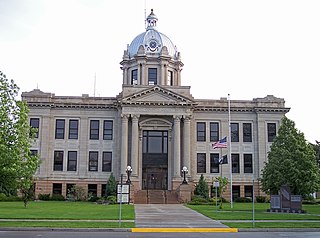
<span class="mw-page-title-main">St. Ansgar, Iowa</span> City in Iowa, United States

St. Ansgar is a city in Mitchell County, Iowa, United States. The population was 1,160 at the 2020 census.

<span class="mw-page-title-main">Ayrshire, Iowa</span> City in Iowa, United States

Ayrshire is a city in Palo Alto County, Iowa, United States. The population was 133 at the 2020 census.

<span class="mw-page-title-main">Dazey, North Dakota</span> City in North Dakota, United States

Dazey is a city in Barnes County, North Dakota, United States. The population was 78 at the 2020 census. Dazey was founded in 1883 after a local farmer, Charles Dazey, donated land to start a townsite.
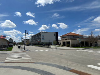
<span class="mw-page-title-main">Valley City, North Dakota</span> City in North Dakota, United States

Valley City is a city in Barnes County, North Dakota, United States. It is the county seat of Barnes County. The population was 6,575 during the 2020 census, making it the 12th most populous city in North Dakota. Valley City was founded in 1874.

<span class="mw-page-title-main">Fort Totten, North Dakota</span> CDP in North Dakota, United States

Fort Totten is a census-designated place (CDP) in Benson County, North Dakota, United States. The population was 1,243 at the 2010 census. Fort Totten is located within the Spirit Lake Reservation and is the site of tribal headquarters. The reservation has a total population estimated at 6,000. Although not formally incorporated as a city, Fort Totten has the largest population of any community in Benson County.

<span class="mw-page-title-main">Horace, North Dakota</span> City in North Dakota, United States

Horace is a city in Cass County, North Dakota, United States. As of the 2020 census, the population was 3,085.

<span class="mw-page-title-main">Halliday, North Dakota</span> City in North Dakota, United States

Halliday is a city in Dunn County, North Dakota, United States. The population was 241 at the 2020 census. Halliday was founded in 1914.

<span class="mw-page-title-main">New Rockford, North Dakota</span> City in North Dakota, United States

New Rockford is a city in Eddy County, North Dakota, United States. It is the county seat of Eddy County. The population was 1,361 at the 2020 census. New Rockford was founded in 1883.

<span class="mw-page-title-main">Cooperstown, North Dakota</span> City in North Dakota, United States

Cooperstown is a city in Griggs County, North Dakota, United States. It is the county seat of Griggs County. The population was 983 at the 2020 census. Cooperstown was founded in 1882.

<span class="mw-page-title-main">Watford City, North Dakota</span> City in North Dakota, United States

Watford City, founded in 1914, is a city in and the county seat of McKenzie County, North Dakota, United States. The population was 6,207 at the 2020 census, making it the 13th most populous city in North Dakota. Because Watford City is part of the Bakken field, the North Dakota oil boom has significantly increased population and construction since the 2010 census.

<span class="mw-page-title-main">New Town, North Dakota</span> City in North Dakota, United States

New Town is a city in Mountrail County, North Dakota. The population was 2,764 at the time of the 2020 census, making it the 18th largest city in North Dakota. New Town was platted in 1950 as a replacement site for the residents of Sanish and Van Hook, as these towns were scheduled to be flooded by the creation of Lake Sakakawea, a reservoir to provide water for irrigation.

<span class="mw-page-title-main">Aneta, North Dakota</span> City in North Dakota, United States

Aneta is a city in Nelson County, North Dakota, United States. The population was 234 at the 2020 census. Aneta was first settled in 1882 and incorporated as a city in 1893.

<span class="mw-page-title-main">Lisbon, North Dakota</span> City in North Dakota, United States

Lisbon is a city in and the county seat of Ransom County, North Dakota, United States. The population was 2,204 at the 2020 census.

<span class="mw-page-title-main">Brookings, South Dakota</span> City in South Dakota, United States

Brookings is a city in Brookings County, South Dakota, United States. Brookings is South Dakota's fourth most populous city, with a population of 23,377 at the 2020 census. It is the county seat of Brookings County, and home to South Dakota State University, the state's largest institution of higher education. Also in Brookings are the South Dakota Art Museum, the Children's Museum of South Dakota, the annual Brookings Summer Arts Festival, and the headquarters of several manufacturing companies and agricultural operations.

<span class="mw-page-title-main">Colton, South Dakota</span> City in South Dakota, United States

Colton is a city in Minnehaha County, South Dakota, United States. The population was 738 at the 2020 census.

<span class="mw-page-title-main">Java, South Dakota</span> Town in South Dakota, United States

Java is a town in Walworth County, South Dakota, United States. The population was 121 at the 2020 census.

References

  1. "ArcGIS REST Services Directory". United States Census Bureau. Retrieved September 20, 2022.
  2. 1 2 U.S. Geological Survey Geographic Names Information System: Sheyenne, North Dakota
  3. 1 2 3 "Explore Census Data". United States Census Bureau . Retrieved November 7, 2023.
  4. 1 2 "City and Town Population Totals: 2020-2022". United States Census Bureau. November 7, 2023. Retrieved November 7, 2023.
  5. "US Gazetteer files 2010". United States Census Bureau. Archived from the original on January 25, 2012. Retrieved June 14, 2012.
  6. United States Census Bureau. "Census of Population and Housing" . Retrieved February 12, 2014.

Further reading