Springfield is a historic neighborhood of Jacksonville, Florida, United States, located to the north of downtown. Established in 1869, it experienced its greatest growth from the early 1880s through the 1920s. The Springfield Historic District is listed in the National Register of Historic Places, and contains some of the city's best examples of 19th and early 20th century architecture.
The Quapaw Quarter of Little Rock, Arkansas, is a section of the city including its oldest and most historic business and residential neighborhoods. The area's name was first given in 1961, honoring the Quapaw Indians who lived in the area centuries ago.

Hillcrest Historic District is a historic neighborhood in Little Rock, Arkansas that was listed on the National Register of Historic Places on December 18, 1990. It is often referred to as Hillcrest by the people who live there, although the district's boundaries actually encompass several neighborhood additions that were once part of the incorporated town of Pulaski Heights. The town of Pulaski Heights was annexed to the city of Little Rock in 1916. The Hillcrest Residents Association uses the tagline "Heart of Little Rock" because the area is located almost directly in the center of the city and was the first street car suburb in Little Rock and among the first of neighborhoods in Arkansas.

Capitol View/Stifft's Station is a neighborhood of Little Rock, Arkansas, in the west-central portion of the city encompassing approximately 1500 homes. Roughly, its boundaries include the area south of West Markham, north of Interstate 630, east of Pine, and west of Summit, as well as south of Riverview between Park and Summit. Capitol View/Stifft's Station is just west of Downtown, north of the Central High School Historic District, southeast of Pulaski Heights and uses the 72205 ZIP code.

The Main Street Historic District encompasses the historic late 19th and early 20th-century commercial heart of Webster, Massachusetts. It consists of fourteen buildings on Main Street in downtown Webster, between High and Church Streets. This area contains the highest concentration of period commercial buildings in the town. The district was listed on the National Register of Historic Places in 1982.

The Lower Highlands Historic District encompasses one of the oldest residential areas of Fall River, Massachusetts. The district is roughly bounded by Cherry, Main, Winter, and Bank Streets, and is located just east of the Downtown Fall River Historic District and directly south of the Highlands Historic District. This area was settled by 1810, has architecture tracing the city's growth as a major industrial center. The historic district was added to the National Register of Historic Places in 1984.

The Governor's Mansion Historic District is a historic district covering a large historic neighborhood of Little Rock, Arkansas. It was listed on the National Register of Historic Places in 1978 and its borders were increased in 1988 and again in 2002. The district is notable for the large number of well-preserved late 19th and early 20th-century houses, and includes a major cross-section of residential architecture designed by the noted Little Rock architect Charles L. Thompson. It is the oldest city neighborhood to retain its residential character.

The Argenta Historic District encompasses significant historic elements of central North Little Rock, Arkansas. The area that is now central North Little Rock was known as Argenta when it was first settled, and remained unincorporated until it was annexed to Little Rock in 1890. William Faucette, a leading Argenta politician and businessman, orchestrated the incorporation of North Little Rock just beyond the annexed area in 1901, and then made a successful petition to separate Argenta from Little Rock into the new municipality in 1903. Subsequent attempts to rename North Little Rock to Argenta have failed.

Highway 190 is a designation for four state highways in Arkansas. Three are low-traffic rural highways in Grant County, with one designation along city streets in Pine Bluff. The rural segments were created in 1965 and 1966, with the Pine Bluff section created in 2000. All segments are maintained by the Arkansas Department of Transportation (ARDOT).
The Ypsilanti Historic District is a historic district located along several blocks on each side of the Huron River in the center of Ypsilanti, Michigan. The original portion of the district was designated a Michigan State Historic Site in 1973 and listed on the National Register of Historic Places in 1978; additions to the district were nationally listed in 1989.

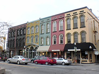
The Ashdown Commercial Historic District encompasses part of the historic commercial heart of Ashdown, the county seat of Little River County, Arkansas. This area was developed primarily between 1905 and 1945, and represents the city's growth during that time as a cotton and lumber center. It covers a roughly two-block area bounded on the west by an alley west of East Main Street, on the north by Keller Street, on the east by Whitaker Street, and on the south by North Constitution Street. Prominent early buildings in the district include the R. M. Price Building, a large two-story brick building built 1905, the 1915 Dixie Theater, and the 1905 Little River News building at 45A E. Main Street. Stylistically distinctive is the 1947 Williams Theater at 360 Keller Street, which is the only Art Deco building in the area.
Inside Little Rock's city limits, there are numerous different neighborhoods. They are Apple Gate, Birchwood, Breckenridge, Broadmoor, Brodie Creek, Candlewood, Capitol View, Capitol View/Stifft's Station, Chenal Ridge, Cloverdale, Colony West, Downtown, East End, Echo Valley, Fair Park, Geyer Springs, Gibraltar Heights, Granite Mountain, Gum Springs, Hall High, The Heights, Highland Park, Hillcrest, John Barrow, Leawood, Mabelvale, Mushroom Pass, Oak Forest, Otter Creek, Parkway Place, Pleasant Valley, Quapaw Quarter, River Mountain, River Ridge, Riverdale, Robinwood, Rock Creek, Rosedale, St. Charles, Santa Fe Heights, Historic South End District/South Little Rock, Southwest Little Rock, Stagecoach, Sturbridge, the Villages of Wellington, Wakefield, West End and Woodland Edge.
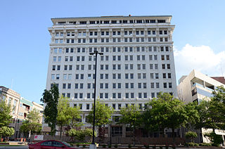
The Capitol–Main Historic District encompasses a well-preserved area of early 19th-century commercial architecture in downtown Little Rock, Arkansas. The district includes 2-1/2 blocks of Capitol Street, extending east from Center Street, one block of Main Street south of Capitol, and one block of 6th Street west of Main. The buildings in this area were mostly built before World War II, and are of a more modest scale than modern sections of the downtown. Notable buildings include the LaFayette Hotel and the Pfeifer Brothers Department Store.

The East Markham Street Historic District encompasses a cluster of four architecturally distinctive commercial buildings on the south side of the 300 block of East Markham Street in the riverfront area of Little Rock, Arkansas. All four are brick two-story buildings, and were built between 1876 and 1905. The buildings at 305-307 and 313 E. Markham are Italianate in style, while 301-303 exhibits Craftsman styling due to a renovation overseen by Charles L. Thompson in 1916, and 323 was also restyled by Thompson in 1905.

The Pine Bluff Commercial Historic District encompasses a portion of the historic city center of Pine Bluff, Arkansas. It extends from Barraque Street south along Main Street, extending in places to properties alongside streets. The area's commercial development began about 1840, when the courthouse square was laid out at Barraque and Main, and proceeded through the early 20th century. Most of the commercial properties of the district were built between 1880 and 1910, and are reflective architecturally of late 19th-century commercial building styles.

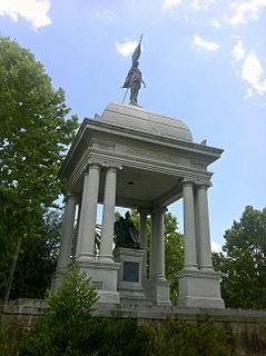
The MacArthur Park Historic District encompasses a remarkably well-preserved collection of Victorian buildings in the heart of Little Rock, Arkansas. The main focal point of the district is MacArthur Park, site of the Tower Building of the Little Rock Arsenal and Little Rock's 19th-century military arsenal. The district extends north and west from the park for about four blocks, to East Capitol Avenue in the north and Scott Street to the west, and extends south, beyond Interstate 630, to East 17th Street. This area contains some of the city's finest surviving antebellum and late Victorian architecture, including an particularly large number (19) of Second Empire houses, and achieved its present form roughly by the 1880s. The MacArthur Park Historic District was listed on the National Register of Historic Places in 1977.

The Main Street Commercial District is a historic district encompassing a typical downtown city block of Little Rock, Arkansas, during the first half of the 20th century. The district consists of ten buildings lining the east side of the 300 block of Main Street. This area was completely redeveloped after a fire in February 1900 sparked an explosion at an arms company, levelling the block. The buildings in the district are stylistically diverse, and were built between 1900 and 1955.

The South Main Street Residential Historic District encompasses a residential area south of downtown Little Rock, Arkansas. The area, extending along South Main Street roughly between 19th and 23rd Streets, was developed between about 1880 and 1945, and includes a well-preserved set of residential architecture from that period. Notable buildings include the Luxor Apartments, the Holcomb Court Apartments, and the Ada Thompson Memorial Home.

The South Scott Street Historic District encompasses a small portion of a residential area south of downtown Little Rock, Arkansas. It includes the 2400 block of South Scott Street, and one block of 24th Street just to its west. Developed between about 1890 and 1950, this area has one of the city's best-preserved concentrations of modest middle-class residences from that period. It includes fourteen buildings, ranging stylistically from the Queen Anne to the post-World War II vernacular.


