South Norwalk, Connecticut

Last updated

South Norwalk
Taxing District
SoNo Signage.jpg
SoNo illuminated sign
USA Connecticut location map.svg
Red pog.svg
South Norwalk
Usa edcp location map.svg
Red pog.svg
South Norwalk
Coordinates: 41°07′N73°25′W / 41.11°N 73.42°W / 41.11; -73.42
Country Flag of the United States.svg United States
State Flag of Connecticut.svg  Connecticut
County Fairfield
City Norwalk
FoundedAugust 18, 1870
Incorporated with NorwalkJune 6, 1913
ZIP code
06854
Area code(s) Area codes 203 and 475

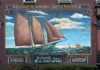
South Norwalk is a neighborhood in Norwalk, Connecticut which corresponds to the city's Second Taxing District. [1] [2] Often referred to as SoNo, [3] [4] [5] the neighborhood was originally settled as Old Well, then chartered as the city of South Norwalk on August 18, 1870. The cities of Norwalk and South Norwalk were incorporated on June 6, 1913. South Norwalk underwent major redevelopment during the early 21st century, with many new apartments being constructed, [4] often in close proximity to South Norwalk station, [4] [5] and generally more expensive than existing housing. [5]

Contents

South Norwalk is a diverse neighborhood both from a socioeconomic and racial perspective.[ citation needed ]

The neighborhood hosts the annual SoNo Arts Festival, an event that showcases local artists, businesses, and musical acts. [6] The annual Norwalk Oyster Festival, sponsored by the Norwalk Seaport Association, is held at Veteran's Memorial Park, across the Norwalk Harbor in East Norwalk. [7]

History

Map of South Norwalk and Norwalk, CT South Norwalk and Norwalk, Conn. (2674626278).jpg
Map of South Norwalk and Norwalk, CT

Old Well

The area of present-day South Norwalk developed out of a local well referred to as the "Old Well", where sailing ships would refill their water casks. [8] Said well was in service since at least 1738, when a deed referred to nearby Washington Street as "the highway that leads to ye landing place called Ye Old Well". [8] The well's location was depicted as east of Water Street, and about 75 feet South of Washington Street in a 1867 map by American cartographer Frederick W. Beers, [8] [9] although the exact location is unknown, though presumed to be near the site of Donovan’s Tavern, since sailors are said to have frequented the tavern. [8]

The area evolved into a settlement named Old Well. after the well, and was involved in coastal trade, manufacturing, and shipbuilding, as well as having many farms with diversified crops. [8]

“Old Well was scarcely a village in those days, but rather a group of farms, and the well which gave the place its name was on Water street, near the corner of Haviland street, on the property of Eliakim Raymond, a patriarch of several Norwalk lines. His house stood at the corner of Washington and Water streets before the Revolution and was burned with rest of the town." [10]

City of South Norwalk

"Norwalk was made a borough in 1836, and the village of Old Well, named from an ancient well where vessels were supplied with water, was incorporated into a city in 1868, and named South Norwalk two years afterward." [11] "South Norwalk, formerly called "Old Well" was organized a city August 18, 1870, under a charter granted by the Legislature of Connecticut, July 5 of the same year". [10] In 1873, the City of South Norwalk was incorporated within the Town of Norwalk, although it maintained its city status and retained control over its own assets. [2] [12] "The 1870 charter was revised by the Legislature April 19, 1882, and the city continued its existence under this revised charter until May 27, 1897, when the Legislature approved a revised and amended charter, under which the city has since continued and worked." [10] [13]

Around this time, Norwalk had refused to share its water system with South Norwalk, contributing to a sense of ill will between the two cities, which would compete for economic development throughout subsequent decades. [2]

"In the 1800s, industrialization started to take place--large factories manufacturing goods such as firearms, buttons, shoes, cloth and hats were increasing in Connecticut and in Norwalk. Workers came up from Chesapeake, Maryland, to work as oystermen. Wealthy owners and managers of businesses lived on Golden Hill overlooking South Norwalk. Immigrants came into Norwalk from many places. One of the largest [group] to come here in the early 1900s was the Hungarians; there were also many Eastern European Jews and Italians, among others." [14]

Horse-drawn trolleys began serving South Norwalk in the 1860s, until being upgraded to electric trolleys in 1894. [8]

Industrialization in South Norwalk resulted in the city becoming a center for local industry, hosting its own railroad station, the Norwalk Harbor, an electric trolley system, its own water company, electric company, and well-developed school system. [2] [12]

Consolidation into Norwalk

Despite the industrialization of South Norwalk, various economic forces pressured the city South Norwalk to merge into Norwalk, as both cities were often too small independent of one another to host large industries. [2] South Norwalk was hesitant to consolidate into Norwalk, due to South Norwalk's industry surpassing that of Norwalk. [2] [12] South Norwalk, alongside East Norwalk, even tried to leave the Town of Norwalk altogether in 1902, with South Norwalk's mayor Mortimer M. Lee touting that South Norwalk had "a large water system, a splendid electric light plant, a separate sewer system, a public library and a library building and schools second to none". [12] In 1903 the Connecticut State Legislature passed a bill to create an independent Town of South Norwalk, but it was vetoed by then-governor Abiram Chamberlain. [12] [15]

As a compromise, Norwalk allowed for South Norwalk, East Norwalk, and Rowayton to join Norwalk as taxing districts, allowing them to largely maintain their own municipal services while within Norwalk. [2]

Within Norwalk

A street scene along a portion of Washington Street, part of the South Main and Washington Streets Historic District created in 1977 SoNo Historic Washington Street 1.jpg
A street scene along a portion of Washington Street, part of the South Main and Washington Streets Historic District created in 1977

In 1935, South Norwalk's trolley system was discontinued, and replaced by a bus service. [8]

South Norwalk began suffering from a period of deindustrialization in the 1950s, as many industries, including Norwalk's sizable hat industry, either went into decline or relocated out of New England. [12] This industrial decay led to the enactment of various urban renewal projects beginning in the 1960s, namely, the demolition of older buildings and factories along western Washington Street to build new offices, a shopping center, and low-cost housing. [12] The Norwalk Redevelopment Agency planned to continue this effort in the 1970s, with plans to replace the older buildings along eastern Washington Street, but were thwarted by local residents, who successfully got the buildings added to the National Register of Historic Places in 1977. [12]

In 1988, the Maritime Aquarium was opened in a disused factory building. [12]

During the 21st century, South Norwalk has seen a period of redevelopment centered around the construction of new apartments, many of which are located near South Norwalk station. [4] [5]

Geography

Administratively, the Norwalk Second Taxing District, synonymous with South Norwalk, is bordered by Route 1 (locally signed as Connecticut Avenue) to the north, and the Norwalk Harbor and the Norwalk River to the east. [16] The neighborhood's southern border runs from Windsor Place to Neptune Avenue, up against the Norwalk River, and the neighborhood's western border runs from Windsor Place up to Connecticut Avenue. [16]

Demographics

All of South Norwalk is represented by the 06854 ZIP Code, which also includes some areas to its south and west. [17] As of 2020, the ZIP Code has an average family income of $74,597, slightly below the Connecticut average of $79,855; the poverty rate is 14.5%, higher than the Connecticut total of 9.8%; 34.2% of the population has a Bachelor's degree or higher, below the state total of 40.0%; the ZIP code has an employment rate 65.4%, higher than the Connecticut total of 61.7%; 22.0% of the population lacks health care coverage, significantly higher than the state total of 5.1%; 22.5% of the population is under 18 years old, slightly higher than the state total of 20.6%; the average household size is 3.25, slightly higher than the state total of 3.08. [17]

The SoNo Collection

The SoNo Collection is a 700,000 square foot mall located next to Interstate 95 and Route 7 that was opened in October 2019. It was built by Brookfield Properties and is the fourth mall in the Fairfield County. It features southern Connecticut’s only Nordstrom and Bloomingdales’s. [18] [19]

National Register of Historic Places

Canaan Institutional Baptist Church Canaan Institutional Baptist Church 002.JPG
Canaan Institutional Baptist Church
Former City Hall NorwalkCTNorwalkMuseum80122007.JPG
Former City Hall

The Norwalk Historical Society along with the Norwalk Historical Commission reopened the Norwalk Historical Society Museum at the Lockwood House at 141 East Avenue. The archives, genealogy and unframed photographs was placed with the “History Room” at the Norwalk Public Library Main branch (1 Belden Ave, Norwalk, CT). It includes items from the four collections: City of Norwalk, Lockwood family, Norwalk Historical Society and the Connecticut Daughters of the American Revolution (DAR) and Norwalk-Village Green Chapter. [23]

Norwalk River Railroad Bridge NorwalkCTNorwalkRivRRBridge08122007.JPG
Norwalk River Railroad Bridge

Emergency services

The Norwalk Police Department [26] is located at 1 Monroe St. near the heart of SoNo. The Norwalk Fire Department currently operates two Fire Stations in or near South Norwalk: [27]

See also

Images

Related Research Articles

<span class="mw-page-title-main">Hartford, Connecticut</span> Capital city of Connecticut, United States

Hartford is the capital city of the U.S. state of Connecticut. It was the seat of Hartford County until Connecticut disbanded county government in 1960. It is the core city in the Greater Hartford metropolitan area. Census estimates since the 2010 United States census have indicated that Hartford is the fourth-largest city in Connecticut with a 2020 population of 121,054, behind the coastal cities of Bridgeport, New Haven, and Stamford.

<span class="mw-page-title-main">Brookfield, Connecticut</span> Town in Connecticut, United States

Brookfield is a town in Fairfield County, Connecticut, United States, situated within the southern foothills of the Berkshire Mountains. The population was 17,528 at the 2020 census. The town is located 55 miles (89 km) northeast of New York City, making it part of the New York metropolitan area. In July 2013, Money magazine ranked Brookfield the 26th-best place to live in the United States, and the best place to live in Connecticut.

<span class="mw-page-title-main">Fairfield County, Connecticut</span> County in Connecticut, United States

Fairfield County is a county in the southwestern corner of the U.S. state of Connecticut. It is the most populous county in the state and was also its fastest-growing from 2010 to 2020. As of the 2020 census, the county's population was 957,419, representing 26.6% of Connecticut's overall population. The closest to the center of the New York metropolitan area, the county contains four of the state's top 7 largest cities—Bridgeport (1st), Stamford (2nd), Norwalk (6th), and Danbury (7th)—whose combined population of 433,368 is nearly half the county's total population.

<span class="mw-page-title-main">Fairfield, Connecticut</span> Town in Connecticut, United States

Fairfield is a town in Fairfield County, Connecticut, United States. It borders the city of Bridgeport and towns of Trumbull, Easton, Weston, and Westport along the Gold Coast of Connecticut. As of 2020 the town had a population of 61,512.

<span class="mw-page-title-main">New Canaan, Connecticut</span> Town in Connecticut, United States

New Canaan is a town in Fairfield County, Connecticut, United States. The population was 20,622 according to the 2020 census.

<span class="mw-page-title-main">Redding, Connecticut</span> Town in Connecticut, United States

Redding is a town in Fairfield County, Connecticut, United States. The population was 8,765 at the 2020 census.

<span class="mw-page-title-main">Danbury, Connecticut</span> City in Connecticut, United States

Danbury is a city in Fairfield County, Connecticut, United States, located approximately 50 miles (80 km) northeast of New York City. Danbury's population as of 2020 was 86,518. It is the seventh largest city in Connecticut.

<span class="mw-page-title-main">Darien, Connecticut</span> Town in Connecticut, United States

Darien is a coastal town in Fairfield County, Connecticut, United States. With a population of 21,499 and a land area of just under 13 square miles, it is the smallest town on Connecticut's Gold Coast. It has the youngest population of any non-college town in Connecticut, a high rate of marriage, and high number of average children per household.

<span class="mw-page-title-main">Stamford, Connecticut</span> City in Connecticut, United States

Stamford is a city in Fairfield County, Connecticut, 34 miles outside of Manhattan. It is Connecticut's second-most populous city, behind Bridgeport. With a population of 135,470, Stamford passed Hartford and New Haven in population as of the 2020 census. It is in the Bridgeport-Stamford-Norwalk-Danbury metropolitan statistical area, which is part of the New York City metropolitan area.

<span class="mw-page-title-main">Westport, Connecticut</span> Town in Connecticut, United States

Westport is a town in Fairfield County, Connecticut, United States, along the Long Island Sound within Connecticut's Gold Coast. It is 52 miles (84 km) northeast of New York City. Westport's public school system is ranked as the top public school district in Connecticut and 17th best school district in the United States.

<span class="mw-page-title-main">Norwalk, Connecticut</span> City in Connecticut, United States

Norwalk is a city located in southwestern Connecticut, United States, in southern Fairfield County, on the northern shore of Long Island Sound. Norwalk lies within both the New York metropolitan area and the Bridgeport metropolitan area.

<span class="mw-page-title-main">Merritt Parkway</span> Parkway in Connecticut

The Merritt Parkway is a limited-access parkway in Fairfield County, Connecticut, with a small section at the northern end in New Haven County. Designed for Connecticut's Gold Coast, the parkway is known for its scenic layout, its uniquely styled signage, and the architecturally elaborate overpasses along the route. As one of the first, oldest parkways in the United States, it is designated as a National Scenic Byway and is also listed in the National Register of Historic Places. Signed as part of Route 15, it runs from the New York state line in Greenwich, where it serves as the continuation of the Hutchinson River Parkway, to Exit 54 in Milford, where the Wilbur Cross Parkway begins. Facing bitter opposition, the project took six years to build in three different sections, with the Connecticut Department of Transportation constantly requiring additional funding due to the area's high property value. The parkway was named for U.S. Congressman Schuyler Merritt. In 2010, the National Trust for Historic Preservation called the Merritt Parkway one of "America's 11 Most Endangered Historic Places".

<span class="mw-page-title-main">Southport, Connecticut</span> Census-designated place in Connecticut, United States

Southport is a census-designated place (CDP) in the town of Fairfield, Connecticut. It is located along Long Island Sound between Mill River and Sasco Brook, where it borders Westport. As of the 2020 census, it had a population of 1,710. Settled in 1639, Southport center has been designated a local historic district since 1967. In 1971, it was listed on the National Register of Historic Places as the Southport Historic District.

<span class="mw-page-title-main">History of Norwalk, Connecticut</span>

The history of Norwalk, Connecticut ranges from pre-contact cultures and Native Americans to the 21st century.

<span class="mw-page-title-main">Greater Bridgeport</span> Metropolitan statistical area in Connecticut, United States

Greater Bridgeport is the metropolitan area centered on the city of Bridgeport in the U.S. state of Connecticut. The area is located in Southwestern Connecticut. In its most conservative form the area consists of the city of Bridgeport and five surrounding towns—Easton, Fairfield, Monroe, Stratford, and Trumbull. This definition of the Bridgeport area has a population of more than 305,000 and is within the Bridgeport-Stamford-Norwalk-Danbury metropolitan statistical area, which consists of all of Fairfield County, Connecticut. The estimated 2015 county population was 948,053. The area is numbered as part of the New York-Newark Combined Statistical Area NY-NJ-CT-PA by the United States Census Bureau.

There are an assortment of public, private, and parochial schools in Norwalk, Connecticut.

The Central or Midtown section of Norwalk, Connecticut is an urbanized area in roughly the geographic center of the city, north of the South Norwalk neighborhood and the Connecticut Turnpike. Wall Street, West Avenue and Belden Avenue are the main thoroughfares. It has also been called "Norwalk Center" or "Downtown Norwalk".

<span class="mw-page-title-main">Beth Israel Synagogue (Norwalk, Connecticut)</span> United States historic place

Beth Israel Synagogue was an historic Orthodox synagogue building located at 31 Concord Street in the South Norwalk section of Norwalk, Connecticut. Built in 1906, the Moorish Revival style building is the only known synagogue building in Connecticut displaying Moorish onion domes, and is an unusual example of an urban wood-frame synagogue. Since 1972, the building has been owned and occupied by the Canaan Institutional Baptist Church. The building was added to the National Register of Historical Places in 1991.

<span class="mw-page-title-main">Bridgeport, Connecticut</span> City in Connecticut, United States

Bridgeport is the most populous municipality in the U.S. state of Connecticut and the fifth-most populous city in New England, with a population of 148,654 in 2020. Located in eastern Fairfield County at the mouth of the Pequonnock River on Long Island Sound, it is a port city 60 miles (97 km) from Manhattan and 40 miles (64 km) from The Bronx. It is bordered by the towns of Trumbull to the north, Fairfield to the west, and Stratford to the east. Bridgeport and other towns in Fairfield County make up the Bridgeport-Stamford-Norwalk-Danbury metropolitan statistical area, the second largest metropolitan area in Connecticut. The Bridgeport-Stamford-Norwalk-Danbury metropolis forms part of the New York metropolitan area.

<span class="mw-page-title-main">Gold Coast (Connecticut)</span> Affluent part of southwestern Connecticut, US

The Gold Coast, also known as Lower Fairfield County or Southwestern Connecticut not limited to the Connecticut panhandle, is an affluent part of Western Connecticut that includes the entire southern portion of Fairfield County as defined by the U.S. Census Bureau, Super-Public Use Microdata Area (Super-PUMA) Region 09600. The area is about 50 miles northeast of New York City, and is home to many wealthy Manhattan business executives. Parts of the region are served by the Western Connecticut Council of Governments.

References

  1. "Taxing District Elections". City of Norwalk. CivicPlus. Archived from the original on March 8, 2022. Retrieved July 5, 2022.
  2. 1 2 3 4 5 6 7 Schuetz, R. A. (October 7, 2017). "Municipal mashup: Mergers long ago created Norwalk's taxing system". The Hour. Retrieved July 5, 2022.
  3. "Visit SoNo". www.visitsono.com. Retrieved July 5, 2022.
  4. 1 2 3 4 Chumney, Richard (June 24, 2021). "Zoning board approves 150-unit apartment building in South Norwalk". The Hour. Retrieved July 5, 2022.
  5. 1 2 3 4 Craven, John (May 16, 2022). "South Norwalk train station to undergo $6M redevelopment plan". News 12 - Long Island. Retrieved July 5, 2022.
  6. "SoNo ARTS FESTIVAL". GORDON FINE ARTS. Archived from the original on July 5, 2022. Retrieved July 5, 2022.
  7. "Norwalk Oyster Festival 2022". www.seaport.org. Retrieved July 5, 2022.
  8. 1 2 3 4 5 6 7 Booth, Dick. "HISTORIC SOUTH NORWALK". norwalkct.org. Archived from the original on July 5, 2022. Retrieved July 5, 2022.
  9. "Plan of Norwalk, Plan of South Norwalk. Fairfield County, Connecticut". David Rumsey Historical Map Collection . Beers, Ellis, & Soule. 1867.
  10. 1 2 3 Weed, Samuel Richards; Norwalk Historical and Memorial Library Association (August 2, 2018). "Norwalk after two hundred & fifty years, an account of the celebration of the 250th anniversary of the charter of the town, 1651--September 11th--1901; including historical sketches of churches, schools, old homes, institutions, eminent men, patriotic and benevolent work, together with the record of soldiers and sailors enlisted in Norwalk from 1676 to 1898. The civic progress in the last century and statistics of commerce and other miscellany of local interest". South Norwalk, Conn., C. A. Freeman. Archived from the original on May 25, 2017. Retrieved August 2, 2018 via Internet Archive.
  11. Howard, R. H.; Crocker, Henry E. (August 2, 1879). A History of New England: Containing Historical and Descriptive Sketches of the Counties, Cities and Principal Towns of the Six New England States, Including, in Its List of Contributors, More Than Sixty Literary Men and Women, Representing Every County in New England. Crocker & Company. p.  300 . Retrieved August 2, 2018 via Internet Archive. South Norwalk Original Settlement.
  12. 1 2 3 4 5 6 7 8 9 Bullen, Isabel (June 14, 2014). "The History of the Second Taxing District". Discovernorwalk.com. Archived from the original on August 4, 2017. Retrieved August 2, 2018.
  13. Conn.), South Norwalk (Norwalk) (August 2, 1898). "Charter of the City, Pub ... 1898". City Printing Company. Archived from the original on June 17, 2016. Retrieved August 2, 2018 via Google Books.
  14. Grant, Lisa Wilson (2014). Norwalk. Arcadia Publishing. ISBN   9781467121163. Archived from the original on April 28, 2016. Retrieved February 1, 2017.
  15. "Meriden Morning Record - Google News Archive Search". news.google.com. Retrieved August 2, 2018.
  16. 1 2 "Archived copy". Archived from the original on January 15, 2015. Retrieved March 27, 2017.{{cite web}}: CS1 maint: archived copy as title (link)
  17. 1 2 "ZCTA5 06854". data.census.gov. United States Census Bureau . Retrieved July 5, 2022.
  18. "The Sono Collection".
  19. Lurye, Rebecca. "SoNo Collection, Norwalk's New Mall, A Retail Anomaly". courant.com. Retrieved August 2, 2018.
  20. "National Register of Historical Places - CONNECTICUT (CT), Fairfield County". Nationalregisterofhistoricplaces.com. Archived from the original on July 22, 2016. Retrieved August 2, 2018.
  21. "National Register of Historical Places - CONNECTICUT (CT), Fairfield County". Nationalregisterofhistoricplaces.com. Archived from the original on March 1, 2017. Retrieved August 2, 2018.
  22. 1 2 "National Register of Historical Places - CONNECTICUT (CT), Fairfield County". Nationalregisterofhistoricplaces.com. Archived from the original on March 1, 2017. Retrieved August 2, 2018.
  23. "Visit Us". Norwalkhistoricalsociety.org. Archived from the original on April 27, 2017. Retrieved February 11, 2017.
  24. "National Register of Historical Places - CONNECTICUT (CT), Fairfield County". Nationalregisterofhistoricplaces.com. Archived from the original on August 17, 2017. Retrieved August 2, 2018.
  25. "National Register of Historical Places - CONNECTICUT (CT), Fairfield County". Nationalregisterofhistoricplaces.com. Archived from the original on June 30, 2016. Retrieved August 2, 2018.
  26. "Police Department - Norwalk, CT - Official Website". Norwalkct.org. Archived from the original on January 8, 2017. Retrieved August 2, 2018.
  27. "Stations / Station Map - Norwalk, CT - Official Website". Norwalkct.org. Archived from the original on December 24, 2016. Retrieved August 2, 2018.