South Vienna, Ohio | |
---|---|
Coordinates: 39°55′47″N83°37′12″W / 39.92972°N 83.62000°W | |
Country | United States |
State | Ohio |
County | Clark |
Township | Harmony |
Government | |
• Mayor | Toni Keller |
Area | |
• Total | 0.65 sq mi (1.69 km2) |
• Land | 0.65 sq mi (1.69 km2) |
• Water | 0.00 sq mi (0.00 km2) |
Elevation | 1,188 ft (362 m) |
Population (2020) | |
• Total | 402 |
• Density | 617.51/sq mi (238.38/km2) |
Time zone | UTC-5 (Eastern (EST)) |
• Summer (DST) | UTC-4 (EDT) |
ZIP code | 45369 |
Area code(s) | 937, 326 |
FIPS code | 39-73796 [3] |
GNIS feature ID | 2399860 [2] |
Website | http://southvienna.org |
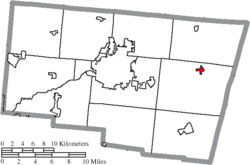
South Vienna is a village in Clark County, Ohio, United States. The population was 402 at the 2020 census. It is part of the Springfield, Ohio Metropolitan Statistical Area.
Located about halfway between Dayton, OH and Columbus, the South Vienna Corn Festival is held in the area on the weekend after Labor Day. The village also has the distinction of having Permit #1, issued by the State of Ohio for traffic lights.[ citation needed ]
South Vienna was originally called Vienna, and under the latter name was platted in 1833. [4] A post office called Vienna Cross Roads was established in 1840, and the name was changed to South Vienna in 1909. [5]
According to the United States Census Bureau, the village has a total area of 0.52 square miles (1.35 km2), all of it land. [6]
Census | Pop. | Note | %± |
---|---|---|---|
1910 | 368 | — | |
1920 | 392 | 6.5% | |
1930 | 398 | 1.5% | |
1940 | 420 | 5.5% | |
1950 | 424 | 1.0% | |
1960 | 440 | 3.8% | |
1970 | 545 | 23.9% | |
1980 | 464 | −14.9% | |
1990 | 550 | 18.5% | |
2000 | 469 | −14.7% | |
2010 | 384 | −18.1% | |
2020 | 402 | 4.7% | |
U.S. Decennial Census [7] |
As of the census [8] of 2010, there were 384 people, 148 households, and 102 families living in the village. The population density was 738.5 inhabitants per square mile (285.1/km2). There were 166 housing units at an average density of 319.2 per square mile (123.2/km2). The racial makeup of the village was 90.4% White, 0.8% African American, 0.5% Native American, 0.5% Asian, 5.7% from other races, and 2.1% from two or more races. Hispanic or Latino of any race were 7.8% of the population.
There were 148 households, of which 35.1% had children under the age of 18 living with them, 48.0% were married couples living together, 16.2% had a female householder with no husband present, 4.7% had a male householder with no wife present, and 31.1% were non-families. 25.0% of all households were made up of individuals, and 8.8% had someone living alone who was 65 years of age or older. The average household size was 2.59 and the average family size was 2.98.
The median age in the village was 40.7 years. 26.8% of residents were under the age of 18; 8.9% were between the ages of 18 and 24; 20.4% were from 25 to 44; 34.4% were from 45 to 64; and 9.6% were 65 years of age or older. The gender makeup of the village was 48.4% male and 51.6% female.
As of the census [3] of 2000, there were 469 people, 166 households, and 131 families living in the village. The population density was 1,157.8 inhabitants per square mile (447.0/km2). There were 173 housing units at an average density of 427.1 per square mile (164.9/km2). The racial makeup of the village was 97.65% White, 0.21% African American, 0.85% from other races, and 1.28% from two or more races. Hispanic or Latino of any race were 2.13% of the population.
There were 166 households, out of which 41.0% had children under the age of 18 living with them, 60.2% were married couples living together, 15.7% had a female householder with no husband present, and 20.5% were non-families. 16.9% of all households were made up of individuals, and 5.4% had someone living alone who was 65 years of age or older. The average household size was 2.83 and the average family size was 3.16.
In the village, the population was spread out, with 32.6% under the age of 18, 8.1% from 18 to 24, 28.4% from 25 to 44, 19.6% from 45 to 64, and 11.3% who were 65 years of age or older. The median age was 32 years. For every 100 females there were 92.2 males. For every 100 females age 18 and over, there were 87.0 males.
The median income for a household in the village was $40,625, and the median income for a family was $51,875. Males had a median income of $36,389 versus $25,833 for females. The per capita income for the village was $17,271. About 8.5% of families and 8.2% of the population were below the poverty line, including 1.3% of those under age 18 and 17.9% of those age 65 or over.
Fort Shawnee is census-designated place (CDP) in Allen County, Ohio, United States. The population was 6,263 at the 2020 census. It is included in the Lima, Ohio Metropolitan Statistical Area. Fort Shawnee is adjacent to the city of Lima and the village of Cridersville in Auglaize County. In 2012, village residents voted to disincorporate the village. According to the United States Census Bureau, the village had a total area of 7.25 square miles (18.78 km2), of which 7.21 square miles (18.67 km2) is land and 0.04 square miles (0.10 km2) is water.
Brookside is a village in eastern Belmont County, Ohio, United States. The population was 538 at the 2020 census. It is part of the Wheeling metropolitan area.
Aberdeen is a village in Huntington Township, Brown County, Ohio, United States, along the Ohio River 50 miles (80 km) southeast of Cincinnati. The population was 1,515 at the 2020 census.
New Vienna is a village in Clinton County, Ohio, United States. The population was 1,108 at the 2020 census.
Warsaw is a village in Coshocton County, Ohio, United States, along the Walhonding River. The population was 624 at the 2020 census.
Wayne Lakes is a village in Darke County, Ohio, United States. The population was 693 at the 2020 census.
Millersport is a village in Fairfield County, Ohio, United States. The population was 978 at the 2020 census. Millersport is most notable as the home of the Sweet Corn Festival, which is held in Millersport annually during the first week of September.
Brice is a village in Franklin County, Ohio, United States, on the southeast side of the Columbus metropolitan area. The population was 93 at the 2020 census.
Metamora is a village in Fulton County, Ohio, United States. The population was 566 at the 2020 census.
Cleves is a village in Miami Township, Hamilton County, Ohio, United States. Located along the Ohio River, it is a western suburb of Cincinnati. The population was 3,414 at the 2020 census.
Evendale is a village in Hamilton County, Ohio, United States, within the Cincinnati metropolitan area. The population was 2,669 at the 2020 census.
Woodlawn is a village in Hamilton County, Ohio, United States. The population was 3,916 at the 2020 census.
Laurelville is a village in Hocking County, Ohio, United States. The population was 512 at the 2020 census.
Hanover is a village in Licking County, Ohio, United States. The population was 1,270 at the 2020 census. The village lies along Ohio State Route 16.
Clarksburg is a village in Ross County, Ohio, United States. The population was 409 at the 2020 census.
Port Washington is a village in Tuscarawas County, Ohio, United States. The population was 548 at the 2020 census.
Bairdstown is a village in Wood County, Ohio, United States. The population was 115 at the 2020 census.
Risingsun is a village in Wood County, Ohio, United States. The population was 541 at the 2020 census.
Vienna is a city in Wood County, West Virginia, United States, situated along the Ohio River. The population was 10,676 at the 2020 census. It is the second-largest city in the Parkersburg–Vienna metropolitan area.
Gratiot is a village in Licking and Muskingum counties in the U.S. state of Ohio. The population was 215 at the 2020 census.