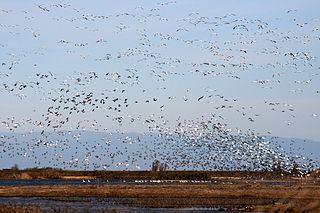
The Sacramento National Wildlife Refuge Complex is part of the United States system of National Wildlife Refuges (NWR). It is located in northern California, in the valley of the Sacramento River.

Sabine National Wildlife Refuge is a National Wildlife Refuge of the United States located in Cameron Parish in southwestern Louisiana. It is on Louisiana State Route 27, 8 miles (13 km) south of Hackberry and 12 miles (19 km) north of Holly Beach. The western boundary of the Sabine Refuge is Sabine Lake, the inlet for Port Arthur, Texas, while the tip of the eastern end reaches Calcasieu Lake.
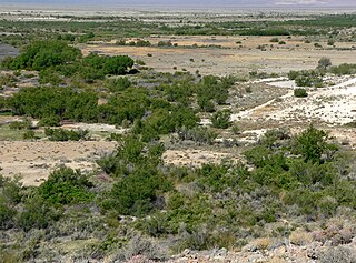
The Ash Meadows National Wildlife Refuge is a protected wildlife refuge located in the Amargosa Valley of southern Nye County, in southwestern Nevada. It is directly east of Death Valley National Park, and is 90 mi (140 km) west-northwest of Las Vegas.

Oregon Islands National Wildlife Refuge is a U.S. National Wildlife Refuge off the southwestern Oregon Coast. It is one of six National Wildlife Refuges comprising the Oregon Coast National Wildlife Refuge Complex. The Oregon Islands provides wilderness protection to 1,853 small islands, rocks, and reefs plus two headlands, totaling 371 acres (150 ha) spanning 1,083 acres (438 ha) of Oregon's coastline from the Oregon–California border to Tillamook Head. There are sites in six of the seven coastal counties of Oregon. From north to south they are Clatsop, Tillamook, Lincoln, Lane, Coos, and Curry counties. The area is managed by the United States Fish and Wildlife Service.
Mandalay National Wildlife Refuge established in 1996, is located in Terrebonne Parish, 5 miles (8.0 km) southwest of Houma, Louisiana. It is one of eight refuges of the Southeast Louisiana National Wildlife Refuge Complex (SELA).
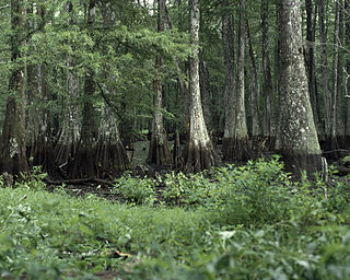
Bayou Cocodrie National Wildlife Refuge was established in 1992 to protect some of the last remaining, least-disturbed bottomland hardwood forest tracts in the Lower Mississippi Valley. These wooded wetlands, oxbow lakes, brakes, sloughs, and bayous, are inhabited seasonally by over 150 species of migratory birds, including forest-breeding birds, water birds, and waterfowl. The 15,155-acre (61.33 km2) refuge is located in Concordia Parish, Louisiana, 10 miles (16 km) southwest of Vidalia, Louisiana. It is named for the state-designated scenic river which runs through its center.
The Atchafalaya National Wildlife Refuge is located about 30 miles (48 km) west of Baton Rouge, Louisiana, and one mile (1.6 km) east of Krotz Springs, Louisiana, lies just east of the Atchafalaya River. In 1988 under the administration of Governor Foster the "Atchafalaya Basin Master Plan" was implemented that combined the 11,780-acre (4,770 ha) Sherburne Wildlife Management Area (WMA), the 15,220-acre (6,160 ha) Atchafalaya National Wildlife Refuge, and the 17,000-acre (6,900 ha) U.S. Army Corps of Engineers' Bayou Des Ourses into the Sherburne Complex Wildlife Management Area.

Black Bayou Lake National Wildlife Refuge is one of five refuges managed in the North Louisiana Refuge Complex and one of 545 refuges in the National Wildlife Refuge System. It was established in 1997 through a unique partnership with the city of Monroe, Louisiana. The U.S. Fish and Wildlife Service has a free 99-year lease to manage the city-owned lake.
Cameron Prairie National Wildlife Refuge is located approximately 25 miles (40 km) southeast of Lake Charles, Louisiana, in north central Cameron Parish. It contains 9,621 acres (3,893 ha) that include fresh marsh, coastal prairie, and old rice fields.

D'Arbonne National Wildlife Refuge is a National Wildlife Refuge of the United States located north of West Monroe, Louisiana. It is in Ouachita and Union Parishes on either side of Bayou D'Arbonne near its confluence with the Ouachita River. It lies on the western edge of the Mississippi River alluvial valley. It was established in 1975 to protect bottomland hardwoods and provide wintering habitat for migratory waterfowl. D'Arbonne is one of four refuges managed in the North Louisiana Refuges Complex.
East Cove National Wildlife Refuge is located south of Lake Charles, Louisiana along the southeast shore of Calcasieu Lake in Cameron Parish. It is accessible only by boat.
Handy Brake National Wildlife Refuge is located just north of Bastrop, Louisiana in Morehouse Parish, north central Louisiana. The refuge was established in 1988 with the southeast's first fee title transfer of a Farmer's Home Administration tract to the U.S. Fish and Wildlife Service. A free lease of 38 acres (150,000 m2) from International Paper increased the refuge to the current 501 acres (2.03 km2).
Lacassine National Wildlife Refuge is located in Cameron and Evangeline Parishes in southwestern Louisiana, was established in 1937 by Executive Order No. 7780 as "a refuge and breeding ground for migratory birds and other wildlife." The refuge is nearly 35,000 acres (140 km2) in size, including 653 acres (2.64 km2) leased from the Cameron Parish School Board. The Evangeline Parish unit is called Duralde Prairie and is currently being developed. It is located south of the city of Eunice.
Lake Ophelia National Wildlife Refuge was established in 1988 to protect the Mississippi/Red River floodplain ecosystem. The refuge is located in Avoyelles Parish, Louisiana, east central Louisiana. The refuge is named for its most prominent water body, the 350-acre (1.4 km2) Lake Ophelia that was at one time a channel of the nearby Red River of the South.
Shell Keys National Wildlife Refuge is located in the offshore waters to the west of the Atchafalaya River Delta, south of Marsh Island Wildlife Management Area. It was established in 1907 and is one of the oldest refuges in the National Wildlife Refuge System.
Upper Ouachita National Wildlife Refuge was established in 1978 and is located in Union and Morehouse Parishes in northern Louisiana.
The North American Wetlands Conservation Act signed into law by President George H. W. Bush on December 13, 1989 authorizes a wetlands habitat program, administered by the United States Fish and Wildlife Service, which provides grants to protect and manage wetland habitats for migratory birds and other wetland wildlife in the United States, Mexico, and Canada. A nine-member council meets periodically to decide which projects to fund.
Sunkhaze Meadows National Wildlife Refuge is located in the Town of Milford, Penobscot County, Maine, approximately fourteen miles north of Bangor. The refuge was established in 1988 to ensure the ecological integrity of the Sunkhaze Meadows peat bog and the continued availability of its wetland, stream, forest and wildlife resources to the citizens of the United States. The purpose of acquisition, under the authority of the Fish and Wildlife Act of 1956 was "... for the development, advancement, management, conservation, and protection of fish and wildlife resources ..." and "... for the benefit of the United States Fish and Wildlife Service, in performing its activities and services. Such acceptance may be subject to the terms of any restrictive or affirmative covenant, or condition of servitude ..." The Land and Water Conservation Fund was the source of funding for the purchase

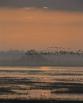
Humboldt Bay National Wildlife Refuge is located on Humboldt Bay, on the California North Coast near the cities of Eureka and Arcata. The refuge exists primarily to protect and enhance wetland habitats for migratory water birds using the bay area, including tens of thousands of shorebirds, ducks, geese, swans, and the black brant. Humboldt Bay National Wildlife Refuge, along with other public and private lands around Humboldt Bay, is one of the key stopovers for the millions of migratory birds that rely on the Pacific Flyway. More than 200 bird species, including 80 kinds of water birds and four endangered species, regularly feed, rest, or nest on the refuge or other areas around the bay.
The Sherburne Complex(Sherburn is a joint land management venture of the U.S. Fish and Wildlife Service, the Louisiana Department of Wildlife and Fisheries, and the U.S. Army Corps of Engineers that began in 1983. The area consists of 43,637 acres, and is managed by the Louisiana Department of Wildlife and Fisheries. The complex is located in the Morganza Flood way system of the Atchafalaya Basin about 30 miles west of Baton Rouge, Louisiana and actually extends a little south of the I-10 Atchafalaya Basin Bridge at Whiskey Bay, Louisiana. The bridge crosses the Whiskey Bay Pilot Channel. Located on the graveled
