Pennypack Creek is a 22.6-mile-long (36.4 km) creek in southeastern Pennsylvania in the United States. It runs southeast through lower Bucks County, eastern Montgomery County and the northeast section of Philadelphia, before emptying into the Delaware River.

Frankford Creek is a minor tributary of the Delaware River in southeast Pennsylvania. It derived its name from the nearby town of Frankford, Philadelphia County. The stream originates as Tookany Creek at Hill Crest in Cheltenham Township and meanders eastward, then southeastward, throughout Cheltenham Township, until a sharp bend near the Philadelphia border at Lawncrest, where the place names Toxony and Tookany were used in historic times; the stream is still known as Tookany Creek in this region, where it flows southwest. Turning south into Philadelphia at the crotch of Philadelphia's Y-shaped border, the creek is called Tacony Creek; from here southward, it is considered the informal boundary separating Northeast Philadelphia from the rest of the city. The Philadelphia neighborhoods of Olney and Feltonville lie on the western side of the stream in this area while Northwood, Lawncrest, Summerdale, and Frankford lie on the eastern side. It continues to be called the Tacony at least until the smaller Wingohocking Creek merges with it in Juniata Park, within the city-owned golf course. Beyond Castor Avenue it is known as Frankford Creek until the stream's confluence with the Delaware River in the Bridesburg neighborhood of Philadelphia, Pennsylvania. The section of stream known as Frankford Creek is 3.1 miles (5.0 km) long, and the upstream section known as Tacony Creek, from Hill Crest, is 11.1 miles (17.9 km) long.

The County Farm Bridge is a historic stone arch bridge in Wilton, New Hampshire. Built in 1885, it carries Old County Farm over Whiting Brook, just south of its northern junction with Burton Highway in a rural section of northwestern Wilton. It is an unusually late and well-preserved example of a 19th-century stone arch bridge, and was listed on the National Register of Historic Places in 1981.

Bridge in Lykens Township No. 1 is a historic multi-span stone arch bridge spanning Pine Creek at Lykens Township, Dauphin County, Pennsylvania. It has two large arches and one small arch. The property measures 127 feet long by 25 feet wide. It features a stone parapet with a concrete cap and concrete parapet.
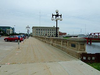
The Civic Center Historic District is located in downtown Des Moines, Iowa, United States. It flanks both the Des Moines and Raccoon Rivers and their confluence. The district has been listed on the National Register of Historic Places since 1988. It is part of The City Beautiful Movement and City Planning in Des Moines, Iowa 1892—1938 MPS.
The Turner County Highway Department and/or its Turner County Highway Superintendent, in Turner County, South Dakota, arranged for the construction of numerous public works.

The Samuel Morey Memorial Bridge is a historic bridge carrying New Hampshire Route 25A across the Connecticut River between Orford, New Hampshire and Fairlee, Vermont. The steel through-arch bridge was built in 1937-38 to replace an older wooden bridge which had been damaged by flooding in 1936. It spans 432 feet (132 m), stands about 35 feet (11 m) above the river, and its arches rise 85 feet (26 m) above the roadway. It rests on poured concrete abutments that have a light Art Deco or Moderne styling. Wing walls recede from the abutments into the banks in three stepped sections. Below the bridge in the river is visible some riprap, stone remnants of the old bridge's abutments and central pier. The bridge is of a "tied arch" design, in which the two arches are joined together by ties to distribute the active load. This is in contrast to the Justice Harlan Fiske Stone Bridge joining Brattleboro, Vermont and Chesterfield, New Hampshire, which was built about the same time, and distributes the active load to its abutments. The bridge components were manufactured by the American Bridge Company; construction was by Hagen-Thibodeau Construction Company at a contracted cost of just over $209,000.

The Bridge No. 63-137-90 is a historic bridge near Parker in rural Turner County, South Dakota. It was built sometime between 1934 and 1936, and is one of a large number of surviving stone bridges built as part of federal jobs programs in the county. It was listed on the National Register of Historic Places in 1999 as Bridge No. 63-137-090-Parker.

The Centerville Township Bridge Number S-18 is a historic stone arch bridge on 294th Lane in rural Turner County, South Dakota, west of Centerville. Built in 1938, it is one of a modest number of surviving stone arch bridges built in the county with funding from New Deal jobs programs. It was listed on the National Register of Historic Places in 2000.
The Childstown Township Bridge Number S-15 is a historic bridge over an unnamed stream on 282nd Street in rural Turner County, South Dakota, west of Hurley. Built in 1940, it is one of a modest number of bridges surviving in the county that was built with New Deal funding. It was listed on the National Register of Historic Places in 2000.
The Dalton Township Bridge is a historic bridge over an unnamed stream on 446th Avenue in rural Turner County, South Dakota, north of Marion. Built in 1936, it is one of a modest number of bridges surviving in the county that was built with New Deal funding. It was listed on the National Register of Historic Places in 2000.
The Daneville Township Bridge No. E-26 is a historic stone arch bridge over an unnamed stream on 457th Avenue in rural Turner County, South Dakota, south of Viborg. Built in 1935, it is one of a modest number of bridges surviving in the county that was built with New Deal funding. It was listed on the National Register of Historic Places in 1999.

The West Sixth Street Bridge is a historic stone arch bridge in downtown Austin, Texas. Built in 1887, the bridge is one of the state's oldest masonry arch bridges. It is located at the site of the first bridge in Austin, carrying Sixth Street across Shoal Creek to link the western and central parts of the old city. The bridge was added to the National Register of Historic Places in 2014.
The Germantown Township Bridge S-29 is a historic stone arch bridge over an unnamed stream on 278th Street in rural Turner County, South Dakota, southwest of Chancellor. Built in 1942, it is one of a modest number of bridges surviving in the county that was built with New Deal funding. It was listed on the National Register of Historic Places in 2000.
The Salem Township Bridge E-1 is a historic stone arch bridge over an unnamed stream on 446th Street in rural Turner County, South Dakota, west of Hurley. Built in 1940, it is one of a modest number of bridges surviving in the county that was built with New Deal funding. It was listed on the National Register of Historic Places in 2000.
South Dakota Department of Transportation Bridge No. 63-016-150 is a historic bridge in rural western Turner County, South Dakota. Built in 1935, it is a well-preserved period stone-arch bridge, built with funding from a New Deal jobs program. It was listed on the National Register of Historic Places in 1999.

South Dakota Department of Transportation Bridge No. 63-132-040 is a historic bridge in rural Turner County, South Dakota. Built in 1939, it is a well-preserved period stone-arch bridge, built with funding from a New Deal jobs program. It was listed on the National Register of Historic Places in 1999.

The South Dakota Department of Transportation Bridge No. 63-160-056 was a historic Pratt through truss bridge in rural Turner County, South Dakota, carrying 476th Avenue across the East Fork Vermillion River northeast of Parker. Built in 1905, it was one two surviving bridges built in the county by the J.A. Crane Company of Centerville, South Dakota. It was listed on the National Register of Historic Places in 1999. It was replaced by a modern steel beam bridge in about 2007.
The South Dakota Department of Transportation Bridge No. 63-197-130 is a historic bridge in rural Turner County, South Dakota, carrying 281st Street across the East Fork Vermillion River north of Davis. Built in 1906, it is the oldest surviving bridge built for the county by the Iowa Bridge Company. It was listed on the National Register of Historic Places in 1999.
South Dakota Department of Transportation Bridge No. 63-198-181 was a historic bridge in rural Turner County, South Dakota, carrying 460th Avenue across the East Fork Vermillion River south of Davis. Built in 1909, it was a well-preserved example of bridges built for the county by the Iowa Bridge Company. It was listed on the National Register of Historic Places in 1999.