Springfield | |
---|---|
Coordinates: 45°50′N64°35′W / 45.84°N 64.59°W | |
Country | Canada |
Province | New Brunswick |
County | Kings County |
Erected | 1786 |
Area | |
• Land | 248.53 km2 (95.96 sq mi) |
Population (2021) [1] | |
• Total | 1,641 |
• Density | 6.6/km2 (17/sq mi) |
• Change 2016-2021 | 7.6% |
• Dwellings | 797 |
Time zone | UTC-4 (AST) |
• Summer (DST) | UTC-3 (ADT) |
Figures do not include portion within the village of Norton |
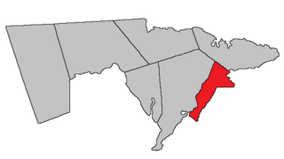
Springfield is a geographic parish in Kings County, New Brunswick, Canada. [2]
Prior to the 2023 governance reform, it was divided for governance purposes between the village of Norton [3] and the local service district of the parish of Norton, [4] both of which were members of Kings Regional Service Commission (RSC8). [5]
The name was common [6] in the Thirteen Colonies, now famously found at least once in every state of the United States.
Notable is that the names of Kings County's pre-1800 parishes all occur in both New Jersey and North Carolina. [7]
Springfield was erected in 1786 as one of the original parishes of the county. [8]
In 1795 the boundaries were altered as part of the reorganisation of Kings County parishes. [9]
In 1860 part of the parish was included in the newly erected Kars Parish. [10]
In 1880 the boundary with Studholm was altered. [11]
In 1896 the southern boundary was altered. [12]
In 1899 the boundary was again altered. [13]
Springfield Parish is bounded: [2] [14] [15] [16]
Communities at least partly within the parish; [14] [15] [16] bold indicates an incorporated municipality
Bodies of water [lower-alpha 2] at least partly in the parish: [14] [15] [16]
Parish population total does not include the village of Norton
Population trend [18] [19] [20]
Census | Population | Change (%) |
---|---|---|
2016 | 1,525 | 7.7% |
2011 | 1,652 | 5.1% |
2006 | 1,572 | 3.2% |
2001 | 1,523 | 0.0% |
1996 | 0.0% | |
1991 | N/A |
Highways and numbered routes that run through the parish, including external routes that start or finish at the parish limits: [21]
Waterborough is a geographic parish in Queens County, New Brunswick, Canada.
Moncton is a geographic parish in Westmorland County, New Brunswick, Canada.
Queensbury is a geographic parish in York County, New Brunswick, Canada.
Blissville is a geographic parish in Sunbury County, New Brunswick, Canada.
Hampstead is a geographic parish in Queens County, New Brunswick, Canada.
Sackville is a geographic parish in Westmorland County, New Brunswick, Canada.
Saint-Léonard is a geographic parish in Madawaska County, New Brunswick, Canada.
Denmark is a geographic parish in Victoria County, New Brunswick, Canada.
Saint Marys is a geographic parish in York County, New Brunswick, Canada.
Westmorland is a geographic parish in Westmorland County, New Brunswick, Canada.
Waterford is a geographic parish in Kings County, New Brunswick, Canada.
Havelock is a geographic parish in Kings County, New Brunswick, Canada.
Studholm is a geographic parish in Kings County, New Brunswick, Canada.
Sussex is a geographic parish in Kings County, New Brunswick, Canada.
Norton is a geographic parish in Kings County, New Brunswick, Canada.
Johnston Parish is a geographic parish in Queens County, New Brunswick, Canada.
Westfield is a geographic parish in Kings County, New Brunswick, Canada.
Kingston is a geographic parish in Kings County, New Brunswick, Canada.
Chipman is a geographic parish in Queens County, New Brunswick, Canada.
Saint Patrick is a geographic parish in Charlotte County, New Brunswick, Canada, located west of St. George and Saint Andrews.