
The University of Kansas Natural History Museum is part of the University of Kansas Biodiversity Institute, a KU designated research center dedicated to the study of the life of the planet.
Thomas Wilson Williamson was a Kansas architect who specialized in designing school buildings in Kansas, Iowa, and Missouri.
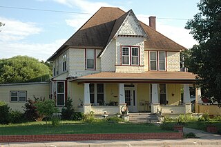
Charles W. Van De Mark House is a Queen Anne style historic building located in Clyde, Kansas, which is listed on the National Register of Historic Places. It was listed in 1985. It was deemed notable " local architectural significance as one of the most elaborate and best preserved of the late nineteenth-century houses of Clyde."

This list is of the properties and historic districts which are designated on the National Register of Historic Places or that were formerly so designated, in Hennepin County, Minnesota; there are 190 entries as of April 2023. A significant number of these properties are a result of the establishment of Fort Snelling, the development of water power at Saint Anthony Falls, and the thriving city of Minneapolis that developed around the falls. Many historic sites outside the Minneapolis city limits are associated with pioneers who established missions, farms, and schools in areas that are now suburbs in that metropolitan area.
This is a complete list of National Register of Historic Places listings in Ramsey County, Minnesota. It is intended to be a complete list of the properties and districts on the National Register of Historic Places in Ramsey County, Minnesota, United States. The locations of National Register properties and districts for which the latitude and longitude coordinates are included below, may be seen in an online map.

This is a list of the National Register of Historic Places listings in Saint Louis County, Minnesota. It is intended to be a complete list of the properties and districts on the National Register of Historic Places in Saint Louis County, Minnesota, United States. The locations of National Register properties and districts for which the latitude and longitude coordinates are included below, may be seen in an online map.

This is a list of the National Register of Historic Places listings in Morrison County, Minnesota. It is intended to be a complete list of the properties and districts on the National Register of Historic Places in Morrison County, Minnesota, United States. The locations of National Register properties and districts for which the latitude and longitude coordinates are included below, may be seen in an online map.

This is a list of the National Register of Historic Places listings in Otter Tail County, Minnesota. It is intended to be a complete list of the properties and districts on the National Register of Historic Places in Otter Tail County, Minnesota, United States. The locations of National Register properties and districts for which the latitude and longitude coordinates are included below, may be seen in an online map.

This is a list of the National Register of Historic Places listings in Marion County, Kansas.

This is a list of the National Register of Historic Places listings in Winona County, Minnesota. It is intended to be a complete list of the properties and districts on the National Register of Historic Places in Winona County, Minnesota, United States. The locations of National Register properties and districts for which the latitude and longitude coordinates are included below, may be seen in an online map.

This is a list of the National Register of Historic Places listings in Itasca County, Minnesota. It is intended to be a complete list of the properties and districts on the National Register of Historic Places in Itasca County, Minnesota, United States. The locations of National Register properties and districts for which the latitude and longitude coordinates are included below, may be seen in an online map.

This is a list of the National Register of Historic Places listings in Le Sueur County, Minnesota. It is intended to be a complete list of the properties and districts on the National Register of Historic Places in Le Sueur County, Minnesota, United States. The locations of National Register properties and districts for which the latitude and longitude coordinates are included below, may be seen in an online map.

This is a list of the National Register of Historic Places listings in Nobles County, Minnesota. It is intended to be a complete list of the properties and districts on the National Register of Historic Places in Nobles County, Minnesota, United States. The locations of National Register properties and districts for which the latitude and longitude coordinates are included below, may be seen in an online map.

The Marais des Cygnes Massacre Site, also known as Marais des Cygnes Massacre Memorial Park, is a state historic site near Trading Post, Kansas that commemorates the 1858 massacre of the same name. On May 19, 1858, during a period of political instability and sporadic violence known as Bleeding Kansas, a group of pro-slavery border ruffians captured 11 abolitionist free-staters. The prisoners were forced to a nearby ravine, where 10 of them were shot, resulting in five fatalities. The abolitionist John Brown later built a fort near the site. The first commemoration at the site was two stone markers erected by men of the 3rd Iowa Cavalry Regiment in 1864, although these monuments had been destroyed by souvenir hunters by 1895. In 1941, the land where the massacre occurred, as well as an 1870s-era house constructed by a friend of Brown, were transferred to the state of Kansas. The site was listed on the National Register of Historic Places in 1971 and designated a National Historic Landmark in 1974. The Kansas Historical Society administers the site, which is interpreted by signage and a hand-cranked audio recording.

The Peabody Downtown Historic District is a historic district which was listed on the National Register of Historic Places (NRHP) in 1998. It is located in Peabody, Kansas.

The Burke–Berryman House, at 418 Cheney St. in Reno, Nevada, is a historic house with elements of Queen Anne and Colonial Revival architecture. It was built c.1909-10 as a rental house in the "Burke's Addition" area of Reno, developed by Charles H. Burke.
Charles W. Terry (1847–1931), commonly known as C.W. Terry, was an architect based in Wichita, Kansas. Several works credited to him and partnerships he was in are listed on the National Register of Historic Places.


