Stillwater, West Coast

Last updated

Stillwater
Stillwater MRD 01.jpg
Stillwater and Mount Buckley
NZ-West Coast plain map.png
Disc Plain red.svg
Stillwater
Coordinates: 42°26′24″S171°21′11″E / 42.44000°S 171.35306°E / -42.44000; 171.35306
CountryNew Zealand
Region West Coast
District Grey District

Stillwater is a town in the South Island of New Zealand east of Greymouth on the banks of the Grey River, at the confluence with the Arnold River, in the Grey District of the West Coast, next to Brunner. There is also a Stillwater, Auckland in the North Island.

Contents

History

The junction of the Arnold and Grey rivers, known as Kotukuwhakaoho, was an important site of battles for Ngāi Tahu, as it was the location where Ngāti Wairangi was defeated in the late 18th century, [1] and later Ngāti Tūmatakōkiri in the 1810s. [2]

The miners who died in the Brunner Mine Disaster on 26 March 1896 were buried in the cemetery at Stillwater. Thirty three men were buried in a mass grave. [3] Hundreds of people came by train from towns on the West Coast to attend the funerals. [4] [5]

In 1906 the town's industry was centred on saw milling. It had a hotel, store, post and telegraph office and a school which opened in 1888. [6]

In 2015 the hotel was still in operation [7] but has since closed.[ citation needed ]

Sawmilling

In November 2009 the saw mill at Stillwater was completely destroyed in a fire. [8] The 2009 West Coast Industry Review by Crown Forestry recommended reducing 'off-Coast' log sales and local processing of the West Coast's wood harvest; it identified Stillwater as the best location for a saw mill because of the ease and cost of cartage. [8] The mill's owners Southern Pine Products rebuilt the mill and took the opportunity to upgrade the plant with the latest technology. Production from the mill recommenced in late 2009. [8]

The mill installed New Zealand's first continuous wood drying kiln in 2010 in addition to its existing batch kiln. It was built by the New Zealand company Windsor Engineering. [9] The continuous drying kiln takes the timber into the kiln on an automated track where it is dried to the right moisture content using heating and heat recovery and forced cooling and conditioning phases. [9]

In 2015 the mill employed 42 full-time staff. [8]

Mass grave at Stillwater for Brunner Mine disaster victimes.jpg
The mass burial of Brunner Mine disaster victims at the Stillwater cemetery.
Mass grave for victims of Brunner Mine disaster, Stillwater cemetery.jpg
The mass grave site in March 2021.

Transport

State Highway 7 passes through Stillwater, and it is a railway junction where the Stillwater - Westport Line meets the Midland Line. The Stillwater Junction Railway Station opened on 14 November 1887. [10] The railway bridge (Bridge 103) was designed by Charles Napier Bell, one of New Zealand's notable colonial civil engineers, and built by the New Zealand Midland Railway Company. It spans Stillwater Creek, west of the station. In 2008–2009 the bridge was rebuilt retaining its original design and heritage features. [11]

The TranzAlpine passenger express train which runs the length of the Midland Line from Christchurch to Greymouth passes through Stillwater, but does not stop. Previous passenger services did stop, e.g. a service to Westport run by RM class Vulcan railcars up to 1967. The station refreshment room closed at the same time. [12]

See also

Timeline of Māori battles

Related Research Articles

<span class="mw-page-title-main">Ahaura River</span> River in the South Island of New Zealand

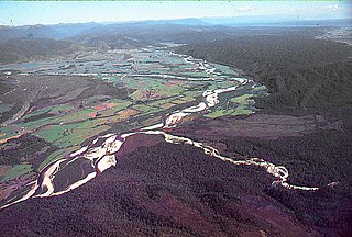
The Ahaura River is in the South Island of New Zealand. This river drains the western flanks of the Southern Alps and flows into the Grey River.

<span class="mw-page-title-main">Greymouth</span> Town in West Coast, New Zealand

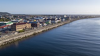
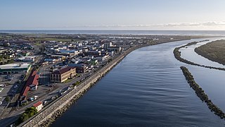
Greymouth is the largest town in the West Coast region in the South Island of New Zealand, and the seat of the Grey District Council. The population of the whole Grey District is 14,250, which accounts for 43% of the West Coast's inhabitants. The Greymouth urban area had an estimated population of 8,340. A large proportion of the District, 65%, is part of the Conservation Estate owned and managed by the Department of Conservation making Greymouth a natural centre for walkers and trampers.

<span class="mw-page-title-main">Lake Brunner</span> Lake in the South Island of New Zealand

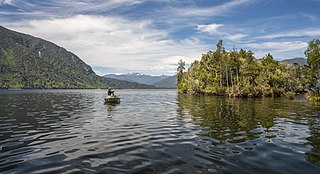
Lake Brunner is the largest lake in the West Coast Region of New Zealand, located 31 km (19 mi) southeast of Greymouth. The main settlement, Moana, is on its northern shore. It is an important settlement and waystation for local Māori. The first Europeans in the area were loggers, and sawmills were an important early industry. Being several kilometres inland from the coast road, it is less frequently visited by tourists than many of the West Coast's scenic highlights, but it is becoming increasingly popular, in part due to its reputation for fishing.

<span class="mw-page-title-main">Taramakau River</span> River in New Zealand

The Taramakau River is a river of the West Coast Region of the South Island of New Zealand. It rises in the Southern Alps / Kā Tiritiri o te Moana near Harper Pass, 80 kilometres (50 mi) due east of Hokitika, and runs westward for 75 kilometres (47 mi) into the Tasman Sea 15 kilometres (9.3 mi) south of Greymouth.

<span class="mw-page-title-main">Reefton</span> Town in the South Island of New Zealand

Reefton is a small town in the West Coast region of New Zealand, some 80 km northeast of Greymouth, in the Inangahua River valley. Ahaura is 44 km south-west of Reefton, Inangahua Junction is 34 km to the north, Maruia is 63 km to the east, and the Lewis Pass is 66 km to the south-east.

<span class="mw-page-title-main">Brunner, New Zealand</span> Place in West Coast, New Zealand

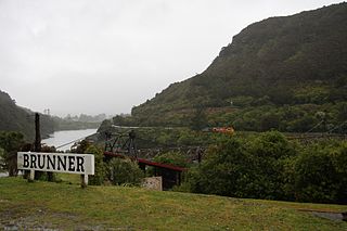
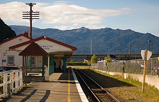
Brunner, originally called Brunnerton, is a town in the northwest of New Zealand's South Island. It is 12 kilometres (7 mi) east of Greymouth, on the south bank of the Grey River. It is on the Midland Line railway near its junction with the Stillwater–Westport Line (SWL) in neighbouring Stillwater. Passenger trains ceased running along the SWL to Reefton and Westport in 1967, but the TranzAlpine runs the length of the Midland Line from Christchurch to Greymouth and it continues to stop in Brunner.

<span class="mw-page-title-main">Grey District</span> Territorial authority district in West Coast Regional Council, New Zealand

Grey District is a district in the West Coast Region of New Zealand that covers Greymouth, Runanga, Blackball, Cobden, and settlements along the Grey River. It has a land area of 3,474.44 square kilometres (1,341.49 sq mi). The seat of the Grey District Council, the local government authority that administers the district, is at Greymouth, where 58.5% of the district's population live.

<span class="mw-page-title-main">Midland Line, New Zealand</span>

The Midland line is a 212 km section of railway between Rolleston and Greymouth in the South Island of New Zealand. The line features five major bridges, five viaducts and 17 tunnels, the longest of which is the Otira tunnel. It is the route of the popular TranzAlpine passenger train.

<span class="mw-page-title-main">New Zealand Midland Railway Company</span>

The New Zealand Midland Railway Company partially constructed the Midland line between Christchurch and Greymouth and the Nelson railway in the South Island. It was one of the few private railway companies in New Zealand, and it did not match the success of the Wellington and Manawatu Railway Company.

<span class="mw-page-title-main">Stillwater–Ngākawau Line</span> Railway line in New Zealand

The Stillwater Ngākawau Line (SNL), formerly the Stillwater–Westport Line (SWL) and the Ngakawau Branch, is a secondary main line, part of New Zealand's national rail network. It runs between Stillwater and Ngakawau via Westport on the West Coast of the South Island. It was one of the longest construction projects in New Zealand's history, with its first section, at the south end, opened in 1889, and the beginnings of the Ngākawau Branch, at its Westport end, in 1875. The full line was completed in 1942. The only slower railway projects were Palmerston North to Gisborne, 1872 to 1942, and the Main North Line to Picton, 1872 to 1945.

Ngahere is a locality in the Grey District of the West Coast of New Zealand's South Island. The 2013 New Zealand census gave the population of Ngahere and its surrounding area as 363, an increase of 5.2% or 18 people since the 2006 census. Ngahere is located on the south bank of the Grey River, and State Highway 7 and the Stillwater–Westport Line (SWL) railway pass through the village.

<span class="mw-page-title-main">Cronadun</span> Place in West Coast, New Zealand

Cronadun is a small village located in the West Coast region of New Zealand's South Island. It is situated on the east bank of the Inangahua River, near its junction with Boatmans Creek. SH 69 and the Stillwater–Westport Line railway pass through the village.

<span class="mw-page-title-main">Ross Branch (railway line)</span>

The Ross Branch, officially known as the Hokitika Line since 2011, and previously as the Hokitika Industrial Line, is a branch line railway that forms part of New Zealand's national rail network. It is located in the Westland District of the South Island's West Coast region and opened to Hokitika in 1893. A further extension to Ross operated from 1909 until 1980.

<span class="mw-page-title-main">Inchbonnie</span> Place in West Coast, New Zealand

Inchbonnie is a rural locality in the West Coast region of the South Island of New Zealand. It is located on the north bank of the Taramakau River and is just to the south of Lake Poerua. "Inchbonnie" is a hybrid of Lowland Scots, bonnie meaning "pretty" and Scottish Gaelic innis meaning island, often anglicised as "Inch", as in Inchkeith or Inchkenneth in Scotland.

<span class="mw-page-title-main">Brunner Mine disaster</span> 1896 mining accident in New Zealand

The Brunner Mine disaster happened at 9:30 am on Thursday 26 March 1896, when an explosion deep in the Brunner Mine, in the West Coast region of New Zealand, killed all 65 miners below ground. The Brunner Mine disaster is the deadliest mining disaster in New Zealand's history.

<span class="mw-page-title-main">Brunner Mine</span> Coal mine near Greymouth, New Zealand

The Brunner Mine was a coal mine on the West Coast of the South Island in New Zealand.

<span class="mw-page-title-main">Ikamatua</span> Town in West Coast, New Zealand

Ikamatua is a small village on the West Coast of the South Island in New Zealand. Its name translates literally as ika (fish) and matua (mature/parent). It may be a contraction of Te Ika-a-matua, fish of my ancestor.

<span class="mw-page-title-main">Grey County, New Zealand</span>

Grey County was one of the counties of New Zealand in the South Island.

<span class="mw-page-title-main">Taylorville, New Zealand</span> Town in New Zealand

Taylorville is a small town on the banks of the Grey River, It is roughly 10 kilometers from the mouth of the river in Greymouth.

The Brunner Borough was a borough on New Zealand's West Coast from 1887 to 1971. It was formed from an area that belonged to Grey County and, at disestablishment, merged back into Grey County.

References

  1. Tumahai, Francois; Wallace, Susan (20 July 2011). "Cultural Impact Assessment of Hokitika Rimu Treetop Walk Māhinapua" (PDF). Department of Conservation . Archived (PDF) from the original on 18 September 2021. Retrieved 18 September 2021.
  2. Mitchell, Hillary; Mitchell, John (1996). "Kehu (Hone Mokehakeha): Biographical Notes". Nelson Historical Society Journal. 6 (1). Archived from the original on 18 September 2021. Retrieved 18 September 2021 via New Zealand Electronic Text Collection.
  3. "Mass grave at Stillwater". teara.govt.nz. Archived from the original on 15 February 2015. Retrieved 22 March 2021.
  4. "The Brunnerton Disaster". Timaru Herald. 30 March 1896. Archived from the original on 12 January 2023. Retrieved 23 March 2021 via PapersPast.
  5. "The Brunner Mine Disaster". Oamaru Mail. 30 March 1896. Archived from the original on 12 January 2023. Retrieved 23 March 2021 via PapersPast.
  6. "Stillwater". The Cyclopedia of New Zealand [Nelson, Marlborough & Westland Provincial Districts]. Christchurch: Cyclopedia Company Limited. 1906. p. 584. Archived from the original on 8 December 2015. Retrieved 30 November 2015 via NZETC.
  7. "Can the West Coast's country pubs stand strong in dark times?". Stuff. 18 September 2015. Archived from the original on 12 January 2023. Retrieved 7 April 2021.
  8. 1 2 3 4 Childerstone, Jim (March 2015). "'Phoenix' rises from the ashes". NZ Logger: 38–40.
  9. 1 2 "First continuous kiln for New Zealand". NZ Logger: 16. October 2010.
  10. Scoble, Juliet (2012). Names & Opening & Closing Dates of Railway Stations in New Zealand, 1863 to 2012. Wellington: Scoble.
  11. Barry, Colin (August–September 2009). "Bridge 103 Midland Line". New Zealand Railway Observer. 296: 91–95.
  12. Churchman, Geoffrey B (1991). On the Trans-Alpine Trail: A Travel Guide to State Highway 73 and the Midland Railway. Johnsonville, Wellington: IPL Books. ISBN   0-908876-73-4.