Summitview, Washington

Last updated

Summitview, Washington
CDP
Yakima County Washington Incorporated and Unincorporated areas Summitview Highlighted.svg
Location of Summitview, Washington
Coordinates: 46°35′54″N120°39′23″W / 46.59833°N 120.65639°W / 46.59833; -120.65639
CountryUnited States
State Washington
County Yakima
Area
  Total
2.6 sq mi (6.7 km2)
  Land2.6 sq mi (6.7 km2)
  Water0.0 sq mi (0.0 km2)
Elevation
[1]
1,355 ft (413 m)
Population
 (2010)
  Total
967
  Density348.6/sq mi (134.6/km2)
Time zone UTC-8 (Pacific (PST))
  Summer (DST) UTC-7 (PDT)
ZIP code
98908 [2]
Area code 509
FIPS code 53-68417 [3]
GNIS feature ID2410021 [1]

Summitview is a census-designated place (CDP) in Yakima County, Washington, United States. The population was 2,066 at the 2020 census, [4] a dramatic increase of 967 from the 2010 census.

Contents

Based on per capita income, Summitview ranks 18th of 522 areas in the state of Washington to be ranked. It is also the highest rank achieved in Yakima County.[ citation needed ]

Geography

According to the United States Census Bureau, the CDP has a total area of 2.6 square miles (6.7 km2), all of it land.

Demographics

Historical population
CensusPop.Note
2000 900
2010 9677.4%
2020 2,066113.7%

As of the census [3] of 2000, there were 900 people, 294 households, and 256 families residing in the CDP. The population density was 348.6 people per square mile (134.7/km2). There were 308 housing units at an average density of 119.3/sq mi (46.1/km2). The racial makeup of the CDP was 94.33% White, 0.33% Native American, 0.22% Pacific Islander, 3.33% from other races, and 1.78% from two or more races. Hispanic or Latino of any race were 7.78% of the population.

There were 294 households, out of which 45.9% had children under the age of 18 living with them, 79.3% were married couples living together, 5.4% had a female householder with no husband present, and 12.9% were non-families. 9.9% of all households were made up of individuals, and 2.7% had someone living alone who was 65 years of age or older. The average household size was 3.06 and the average family size was 3.29.

In the CDP, the age distribution of the population shows 29.8% under the age of 18, 6.4% from 18 to 24, 27.0% from 25 to 44, 26.6% from 45 to 64, and 10.2% who were 65 years of age or older. The median age was 40 years. For every 100 females, there were 100.4 males. For every 100 females age 18 and over, there were 103.9 males.

The median income for a household in the CDP was $66,944, and the median income for a family was $67,083. Males had a median income of $48,036 versus $25,139 for females. The per capita income for the CDP was $36,301. About 2.8% of families and 2.6% of the population were below the poverty line, including none of those under age 18 and 11.5% of those age 65 or over.

Related Research Articles

<span class="mw-page-title-main">First Mesa, Arizona</span> CDP in Navajo County, Arizona

First Mesa is a census-designated place (CDP) in Navajo County, Arizona, United States, on the Hopi Reservation. As of the 2010 census, the CDP population was 1,555, spread among three Hopi villages atop the 5,700-foot mesa: Hano, Sitsomovi, and Waalpi.

<span class="mw-page-title-main">Washington Heights, New York</span> CDP in New York, United States

Washington Heights is a census-designated place (CDP) in Orange County, New York, United States. The population was 2,205 at the 2020 census.

<span class="mw-page-title-main">Thompsonville, Pennsylvania</span> Census-designated place in Pennsylvania, United States

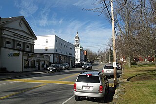
Thompsonville is a census-designated place (CDP) in Washington County, Pennsylvania, United States. The population was 3,520 at the 2010 census.

<span class="mw-page-title-main">Mount Vista, Washington</span> Census-designated place in Washington, United States

Mount Vista is a census-designated place (CDP) in Clark County, Washington, United States. It includes the Vancouver campus of Washington State University. The population of Mount Vista was 10,051 at the 2020 census.

<span class="mw-page-title-main">Cascade Valley, Washington</span> Census-designated place in Washington, United States

Cascade Valley is a census-designated place (CDP) in Grant County, Washington, United States. The population was 2,246 at the 2010 census, up from 1,811 at the 2000 census.

<span class="mw-page-title-main">Lakeland South, Washington</span> Census-designated place in Washington, United States

Lakeland South is a census-designated place (CDP) in King County, Washington, United States. The population was 13,169 at the 2020 census.

<span class="mw-page-title-main">Easton, Washington</span> Census-designated place in Washington, United States

Easton is an unincorporated community and census-designated place (CDP) in Kittitas County, Washington, United States. The population was 478 at the 2010 census. Easton is the annual site of the start/finish line for the Cascade Crest 100-mile ultra-running race.

<span class="mw-page-title-main">Nespelem Community, Washington</span> CDP in Washington, United States

Nespelem Community is a census-designated place (CDP) in Okanogan County, Washington, United States. The population was 283 at the 2020 census.

<span class="mw-page-title-main">Rockport, Washington</span> CDP in Washington, United States

Rockport is a census-designated place (CDP) in Skagit County, Washington, United States. The population was 109 at the 2010 census. It is included in the Mount Vernon–Anacortes, Washington Metropolitan Statistical Area.

<span class="mw-page-title-main">Machias, Washington</span> CDP in Washington, United States

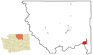
Machias is a census-designated place (CDP) in Snohomish County, Washington, United States. The population was 1,264 at the 2020 census.

<span class="mw-page-title-main">Lake Stickney, Washington</span> CDP in Washington, United States

Lake Stickney is a census-designated place (CDP) in Snohomish County, Washington, United States. The population was 15,413 at the 2020 census. The CDP was known as Paine Field-Lake Stickney prior to 2010. The new Lake Stickney CDP no longer contains the Paine Field airport.

<span class="mw-page-title-main">Ahtanum, Washington</span> CDP in Washington, United States

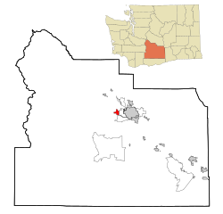
Ahtanum is a census-designated place (CDP) in Yakima County, Washington. The population was 4,046 at the time of the 2020 census.

<span class="mw-page-title-main">Eschbach, Washington</span> CDP in Washington, United States

Eschbach is a census-designated place (CDP) in Yakima County, Washington, United States. The population was 441 at the 2020 census.

<span class="mw-page-title-main">Gleed, Washington</span> CDP in Washington, United States

Gleed is a census-designated place (CDP) in Yakima County, Washington, United States. The population was 2,873 at the 2020 census.

<span class="mw-page-title-main">Satus, Washington</span> CDP in Washington, United States

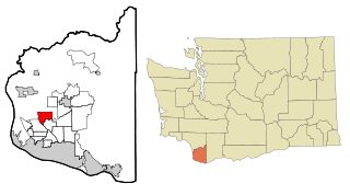
Satus is a census-designated place (CDP) in Yakima County, Washington, United States, located on the eastern corner of the Yakama Indian Reservation. The population was 746 at the 2000 census. It is southwest from the Toppenish National Wildlife Refuge. The community was not recognized in the 2010 census. The area was first settled and established as a post office location in 1890.

<span class="mw-page-title-main">Terrace Heights, Washington</span> CDP in Washington, United States

Terrace Heights is a census-designated place (CDP) in Yakima County, Washington, United States. The population was 9,244 at the 2020 census. It is essentially a suburb of the city of Yakima.

<span class="mw-page-title-main">Union Gap, Washington</span> City in Washington, United States

Union Gap is a city in Yakima County, Washington, United States. The population was 6,568 at the 2020 census. Union Gap has become the retail hub for the entire Yakima Valley as a result of Valley Mall and other thriving businesses being located here. Part of the city is within the Yakama Nation.

<span class="mw-page-title-main">West Valley, Washington</span> CDP in Washington, United States

West Valley is a former census-designated place (CDP) in Yakima County, Washington, United States. The area has been annexed by the city of Yakima. The population was 10,433 at the 2000 census.

<span class="mw-page-title-main">White Swan, Washington</span> CDP in Washington, United States

White Swan is a census-designated place (CDP) in Yakima County, Washington, United States. The population was 789 at the 2020 census.

<span class="mw-page-title-main">North Brookfield (CDP), Massachusetts</span> CDP in Massachusetts, United States

North Brookfield is a census-designated place (CDP) in the town of North Brookfield in Worcester County, Massachusetts, United States. The population was 2,265 at the 2010 census.

References

  1. 1 2 U.S. Geological Survey Geographic Names Information System: Summitview, Washington
  2. "Summitview WA ZIP Code". zipdatamaps.com. 2023. Retrieved June 16, 2023.
  3. 1 2 "U.S. Census website". United States Census Bureau . Retrieved January 31, 2008.
  4. "Census Bureau profile: Summitview, Washington". United States Census Bureau. May 2023. Retrieved May 9, 2024.