Village of Superior | |
---|---|
Coordinates: 46°39′22″N92°6′13″W / 46.65611°N 92.10361°W | |
Country | United States |
State | Wisconsin |
County | Douglas |
Area | |
• Total | 1.25 sq mi (3.23 km2) |
• Land | 1.24 sq mi (3.22 km2) |
• Water | 0.01 sq mi (0.01 km2) |
Population | |
• Total | 664 |
• Estimate (2019) [3] | 705 |
• Density | 567.63/sq mi (219.16/km2) |
Time zone | UTC-6 (Central (CST)) |
• Summer (DST) | UTC-5 (CDT) |
Area code(s) | 715 and 534 |
FIPS code | 55-78660 [4] |
Website | www.villageofsuperior.org |
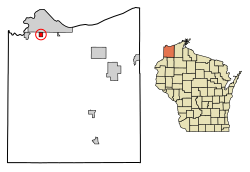
The Village of Superior is a village in Douglas County, Wisconsin, United States. The population was 664 at the 2010 census. The village is located within the Town of Superior and is located immediately south of and adjacent to the City of Superior.
Wisconsin Highway 35 (Tower Avenue) serves as a main route in the village.
Superior is located at 46°39′22″N92°6′13″W / 46.65611°N 92.10361°W (46.65614, -92.103638). [5]
According to the United States Census Bureau, the village has a total area of 1.24 square miles (3.21 km2), of which, 1.23 square miles (3.19 km2) of it is land and 0.01 square miles (0.03 km2) is water. [6]
Census | Pop. | Note | %± |
---|---|---|---|
1950 | 339 | — | |
1960 | 374 | 10.3% | |
1970 | 476 | 27.3% | |
1980 | 580 | 21.8% | |
1990 | 481 | −17.1% | |
2000 | 500 | 4.0% | |
2010 | 664 | 32.8% | |
2019 (est.) | 705 | [3] | 6.2% |
U.S. Decennial Census [7] |
As of the census [2] of 2010, there were 664 people, 299 households, and 194 families living in the village. The population density was 539.8 inhabitants per square mile (208.4/km2). There were 309 housing units at an average density of 251.2 per square mile (97.0/km2). The racial makeup of the village was 97.0% White, 0.2% African American, 1.1% Native American, 0.3% Asian, 0.2% from other races, and 1.4% from two or more races. Hispanic or Latino of any race were 1.1% of the population.
There were 299 households, of which 28.8% had children under the age of 18 living with them, 51.5% were married couples living together, 9.0% had a female householder with no husband present, 4.3% had a male householder with no wife present, and 35.1% were non-families. 30.8% of all households were made up of individuals, and 18% had someone living alone who was 65 years of age or older. The average household size was 2.22 and the average family size was 2.73.
The median age in the village was 47.1 years. 20.5% of residents were under the age of 18; 4.7% were between the ages of 18 and 24; 21.2% were from 25 to 44; 33.1% were from 45 to 64; and 20.5% were 65 years of age or older. The gender makeup of the village was 48.2% male and 51.8% female.
As of the census [4] of 2000, there were 500 people, 209 households, and 158 families living in the village. The population density was 404.7 people per square mile (155.7/km2). There were 210 housing units at an average density of 170.0/sq mi (65.4/km2). The racial makeup of the village was 96.80% White, 0.60% Black or African American, 1.00% Native American, 1.20% Asian, 0.20% from other races, and 0.20% from two or more races. 0.20% of the population were Hispanic or Latino of any race. 17.1% were of German, 15.1% Swedish, 11.4% Norwegian, 11.1% Polish, 10.3% Finnish, 7.1% Irish and 6.0% French ancestry according to Census 2000.
There were 209 households, out of which 30.6% had children under the age of 18 living with them, 63.2% were married couples living together, 10.0% had a female householder with no husband present, and 24.4% were non-families. 20.6% of all households were made up of individuals, and 11.0% had someone living alone who was 65 years of age or older. The average household size was 2.39 and the average family size was 2.76.
In the village, the population was spread out, with 21.0% under the age of 18, 8.4% from 18 to 24, 25.4% from 25 to 44, 28.6% from 45 to 64, and 16.6% who were 65 years of age or older. The median age was 43 years. For every 100 females, there were 94.6 males. For every 100 females age 18 and over, there were 98.5 males.
The median income for a household in the village was $60,092, and the median income for a family was $72,385. Males had a median income of $59,722 versus $15,625 for females. The per capita income for the village was $39,328. About 0.7% of families and 0.8% of the population were below the poverty line, including none of those under the age of eighteen or sixty-five or over.
Hartford is a city in Geneva County, Alabama, United States. It incorporated in 1896. It is part of the Dothan, Alabama Metropolitan Statistical Area. At the 2020 census, the population was 2,651, an increase over the figure of 2,624 tabulated in 2010.
Shageluk is a city in Yukon-Koyukuk Census Area, Alaska, United States. At the 2010 census the population was 83, down from 129 in 2000.
Scottville is a village in Macoupin County, Illinois, United States. The population was 93 at the 2020 census.
Hansell is a city in Franklin County, Iowa, United States. The population was 82 at the time of the 2020 census.
Fort Johnson North is a census-designated place (CDP) in Vernon Parish, Louisiana, United States. The population was 3,279 at the 2000 census. It is part of the Fort Johnson South Micropolitan Statistical Area.
Greenbush Township is a civil township of Clinton County in the U.S. state of Michigan. The population was 2,143 at the 2020 census.
Wheeling Township is a rural township in Rice County, Minnesota, United States. The population was 541 at the 2000 census.
Hillsdale is a village in St. Louis County, Missouri, United States. Greenwood Cemetery is located in Hillsdale. The population was 1,478 at the 2010 census.
Cedar Creek is a village in Cass County, Nebraska, United States. The population was 465 at the 2020 census.
Fort Shawnee is census-designated place (CDP) in Allen County, Ohio, United States. The population was 6,263 at the 2020 census. It is included in the Lima, Ohio Metropolitan Statistical Area. Fort Shawnee is adjacent to the city of Lima and the village of Cridersville in Auglaize County. In 2012, village residents voted to disincorporate the village. According to the United States Census Bureau, the village had a total area of 7.25 square miles (18.78 km2), of which 7.21 square miles (18.67 km2) is land and 0.04 square miles (0.10 km2) is water.
Addyston is a village in Miami Township, Hamilton County, Ohio, United States. Located along the Ohio River, it is a western suburb of the neighboring city of Cincinnati. The population was 927 at the 2020 census.
Port Jefferson is a village in Salem Township, Shelby County, Ohio, United States. The population was 308 at the 2020 census.
Congress is a village in Wayne County, Ohio, United States. The population was 132 at the 2020 census.
Industry is a borough in western Beaver County, Pennsylvania, United States, along the Ohio River. As of the 2020 census, the population was 1,838. It is part of the Pittsburgh metropolitan area.
Colburn is a town in Adams County in the U.S. state of Wisconsin. The population was 215 at the 2020 census, down from 223 at the 2010 census. The town was most likely named for Sherman Colburn, who immigrated to Wisconsin from Vermont in 1855 and became a farmer in the area.
Oliver is a village in Douglas County, Wisconsin, United States. The population was 423 at the 2020 census.
Combined Locks is a village in Outagamie County, Wisconsin, United States. The population was 3,328 at the 2010 census.
Dorchester is a village in Clark and Marathon counties in the U.S. state of Wisconsin, along the 45th parallel. It is part of the Wausau, Wisconsin Metropolitan Statistical Area. The population was 876 at the 2010 census. Of this, 871 were in Clark County, and only 5 were in Marathon County.
Bloomington is a village in Grant County, Wisconsin, United States. The population was 735 as of the 2010 census. The village is located within the Town of Bloomington.
Elderon is a village in Marathon County, Wisconsin, United States. It is part of the Wausau, Wisconsin Metropolitan Statistical Area. The population was 179 at the 2010 census.